Bosljiva Loka
Bosljiva Loka | |
|---|---|
 | |
 Bosljiva Loka Geografska lega v Sloveniji | |
| Koordinati: 45°30′46.99″N 14°46′0.87″E / 45.5130528°N 14.7669083°E | |
| Država | |
| Statistična regija | Jugovzhodna Slovenija |
| Tradicionalna pokrajina | Dolenjska |
| Občina | Osilnica |
| Površina | |
| • Skupno | 5,09 km2 |
| Nadm. višina | 261,3 m |
| Prebivalstvo (2020)[1] | |
| • Skupno | 28 |
| • Gostota | 5,5 preb./km2 |
| Časovni pas | UTC+1 (CET) |
| • Poletni | UTC+2 (CEST) |
| Poštna številka | 1337 Osilnica |
| Zemljevidi | |
Bosljiva Loka je naselje v Občini Osilnica. Leži ob reki Kolpi, ki je hkrati meja s Hrvaško.
Galerija
[uredi | uredi kodo]-
 Pogled proti vzhodu
 -
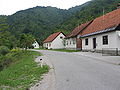 Običajen prihod v vas
 -
 Cerkev Sv. Vida


Sklici
[uredi | uredi kodo]Glej tudi
[uredi | uredi kodo]Zunanje povezave
[uredi | uredi kodo] Predstavnosti o temi Bosljiva Loka v Wikimedijini zbirki
Text is available under the CC BY-SA 4.0 license; additional terms may apply.
Images, videos and audio are available under their respective licenses.
Cover photo is available under {{::mainImage.info.license.name || 'Unknown'}} license.
Cover photo is available under {{::mainImage.info.license.name || 'Unknown'}} license.
Credit:
(see original file).
