For faster navigation, this Iframe is preloading the Wikiwand page for Súbor:Island of Ireland location map Meath.svg.

Súbor:Island of Ireland location map Meath.svg
Pôvodný súbor(SVG súbor, 1 450 × 1 807 pixelov, veľkosť súboru: 642 KB)

Tento zdieľaný súbor je z Wikimedia Commons a je možné ho používať na iných projektoch. Nižšie sú zobrazené informácie z popisnej stránky súboru.

Popis
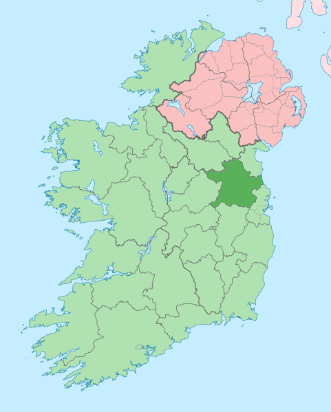
English: The island of Ireland, showing international border between Northern Ireland and Republic of Ireland, traditional provinces, traditional counties, and local authority areas in the Republic of Ireland and Northern Ireland.
Dátum (UTC)
Zdroj
Autor


Toto je upravený obrázek, což znamená, že byl oproti původní verzi digitálně změněn. Úpravy: Coloured in regions with county of article highlighted. Původní verzi je možné zhlédnout zde: Island of Ireland location map.svg. Úpravy provedl Mabuska.

Ja, držiteľ autorských práv k tomuto dielu ho týmto zverejňujem za podmienok nasledovnej licencie:
w:sk:Creative Commons
uvedenie autorov meniť za rovnakých podmienok
Môžete slobodne:
  • zdieľať – kopírovať, šíriť a prenášať dielo
  • meniť ho – upravovať dielo
Za nasledovných podmienok:
  • uvedenie autorov – Musíte spomenúť autorov (jednotlivo alebo kolektívne), poskytnúť odkaz na licenciu a uviesť, či ste niečo zmenili. Môžete to urobiť ľubovoľným primeraným spôsobom, ale nie spôsobom naznačujúcim, že poskytovateľ licencie podporuje vás alebo vaše použitie diela.
  • meniť za rovnakých podmienok – Ak toto dielo zmeníte, prevediete do inej formy alebo použijete ako základ iného diela, musíte výsledok šíriť pod rovnakou alebo kompatibilnou licenciou ako originál.

Pôvodný záznam nahrávaní

This image is a derivative work of the following images:

  • File:Island_of_Ireland_location_map.svg licensed with Cc-by-sa-3.0
    • 2010-03-06T20:43:33Z Rannpháirtí anaithnid 1450x1807 (679207 Bytes) Fix incorrectly coloured isands.
    • 2010-03-03T22:19:29Z Rannpháirtí anaithnid 1450x1807 (679744 Bytes) ((Information |Description=((de|Positionskarte von [[:de:Irland|Irland]])) Quadratische Plattkarte, N-S-Streckung 170 %. Geographische Begrenzung der Karte: * N: 55.6° N * S: 51.2° N * W: 11.0° W * O: 5.0° W ((en|Location

Uploaded with derivativeFX

Štítky

Pridajte jednoriadkové vysvetlenie, čo tento súbor predstavuje
Meath on a map

Položky prezentované týmto súborom

motív

19. júl 2010

image/svg+xml

657 242 bajt

1 807 obrazový prvok

1 450 obrazový prvok

b25342924c77bc832bfaed5e4a1aa9f3569dc1ac

História súboru

Po kliknutí na dátum/čas uvidíte ako súbor vyzeral vtedy.

Dátum/ČasNáhľadRozmeryPoužívateľKomentár
aktuálna09:16, 3. júl 2020Náhľad verzie z 09:16, 3. júl 20201 450 × 1 807 (642 KB)ChipmunkdavisPer the Local Government Reform Act 2014, joining both Tipperarys and both Waterfords (and removing Limerick City code). Colouring in islands, cleaning up and grouping code to remove stray objects and show Galway and Lough Ree.
01:00, 19. júl 2010Náhľad verzie z 01:00, 19. júl 20101 450 × 1 807 (815 KB)Mabuska((Information |Description=((en|The island of Ireland, showing international border between Northern Ireland and Republic of Ireland, traditional provinces, traditional counties, and local authority areas in the Republic of Ireland and Northern Ireland.))

Použitie súboru

Na tento súbor odkazuje nasledujúca stránka:

Globálne využitie súborov

Metadáta

{{bottomLinkPreText}} {{bottomLinkText}}
Súbor:Island of Ireland location map Meath.svg
Listen to this article

This browser is not supported by Wikiwand :(
Wikiwand requires a browser with modern capabilities in order to provide you with the best reading experience.
Please download and use one of the following browsers:

This article was just edited, click to reload
This article has been deleted on Wikipedia (Why?)

Back to homepage

Please click Add in the dialog above
Please click Allow in the top-left corner,
then click Install Now in the dialog
Please click Open in the download dialog,
then click Install
Please click the "Downloads" icon in the Safari toolbar, open the first download in the list,
then click Install
{{::$root.activation.text}}

Install Wikiwand

Install on Chrome Install on Firefox
Don't forget to rate us

Tell your friends about Wikiwand!

Gmail Facebook Twitter Link

Enjoying Wikiwand?

Tell your friends and spread the love:
Share on Gmail Share on Facebook Share on Twitter Share on Buffer

Our magic isn't perfect

You can help our automatic cover photo selection by reporting an unsuitable photo.

This photo is visually disturbing This photo is not a good choice

Thank you for helping!


Your input will affect cover photo selection, along with input from other users.

X

Get ready for Wikiwand 2.0 🎉! the new version arrives on September 1st! Don't want to wait?