Truyère
| Truyère | |
|---|---|
 The Truyère in Entraygues-sur-Truyère | |
 | |
| Location | |
| Country | France |
| Physical characteristics | |
| Source | |
| - location | Massif Central |
| - elevation | 1,450 m (4,760 ft) |
| Mouth | |
| - location | Lot |
| - coordinates | 44°38′37″N 2°33′45″E / 44.64361°N 2.56250°E |
| Length | 167 km (104 mi) |
| Basin size | 3,300 km2 (1,300 sq mi) |
| Discharge | |
| - average | 60 m3/s (2,100 cu ft/s) |
| Basin features | |
| Progression | Lot→ Garonne→ Atlantic Ocean |
| Tributaries | |
| - left | Bès |
| - right | Goul |
The Truyère (Occitan: Truèire) is a river in southwestern France. It is the main tributary of the Lot river.
Geography
[change | change source]The Truyère river has a length of 167.2 km (103.9 mi) and a drainage basin with an area of 5,507 km2 (2,126 sq mi).[1]
Its average yearly discharge (volume of water which passes through a section of the river per unit of time) is 69.5 cubic metres per second at Entraygues-sur-Truyèret.[2]
Course
[change | change source]The Truyère starts in the Margeride mountains, south-western Massif Central, north of Mende, in the "commune" of La Villedieu (Lozère department), at an altitude of about 1,460 m (4,790 ft).[3]
The Truyère flows to the west, in general, and passes through 2 regions, 3 departments and 44 communes:[1]
- Occitanie region
- Lozère: Le Malzieu-Ville, Chaulhac, Saint-Léger-du-Malzieu, Rimeize, Blavignac, Saint-Pierre-le-Vieux, Fontans, Saint-Gal, Serverette
- Auvergne-Rhône-Alpes region
- Cantal: Saint-Martial, Chaliers, Oradour, Fridefont, Alleuze, Faverolles, Neuvéglise
- Occitanie region
- Aveyron: Entraygues-sur-Truyère, Thérondels, Cantoin, Montézic, Brommat
Finally, it flows, as a right tributary, into the Lot river, in Entraygues-sur-Truyèret, in the Aveyron department, at 228 m (748 ft) of altitude.[4]
The Garabit Viaduct is a bridge over the Truyère near Ruynes-en-Margeride that was built by Gustave Eiffel.
There are several dams over the river to produce hydroelectricity.
Main tributaries
[change | change source]The main tributaries of the Truyère river are:
|
Left tributaries:
|
|
Right tributaries:
|
Gallery
[change | change source]-
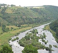 Truyère river from Chaliers
 -
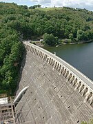 Sarrans dam
 -
-
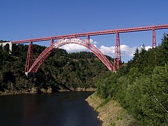 The Garabit Viaduct


Related pages
[change | change source]References
[change | change source]- ↑ 1.0 1.1 "La Truyère (O7--0250)" (in French). SANDRE - Portail national d'accès aux référentiels sur l'eau. Archived from the original on 3 March 2016. Retrieved 13 September 2016.
- ↑ "La Truyère à Entraygues-sur-Truyère" (in French). Banque Hydro. Archived from the original on 20 December 2016. Retrieved 13 September 2016.
- ↑ "Source de La Truyère" (in French). Géoportail. Retrieved 13 September 2016.
- ↑ "Confluence de La Truyère" (in French). Géoportail. Retrieved 22 May 2014.
Other websites
[change | change source]- La Truyère (O7--0250) Archived 2020-09-27 at the Wayback Machine (in French)
Text is available under the CC BY-SA 4.0 license; additional terms may apply.
Images, videos and audio are available under their respective licenses.
