File:Jamaica parishes numbered2.png
No higher resolution available.
Jamaica_parishes_numbered2.png (400 × 159 pixels, file size: 56 KB, MIME type: image/png)
| This is a file from the Wikimedia Commons. Information from its description page there is shown below. Commons is a freely licensed media file repository. You can help. |
Summary
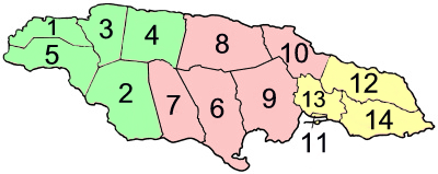
| Description | Parishes and counties of Jamaica alternative numeration |
| Date | |
| Source | own work based on Jamaica_parishes_numbered.png by User:Golbez |
| Author | user:ranas |
Licensing
This file is licensed under the Creative Commons Attribution-Share Alike 2.5 Generic license.
- You are free:
- to share – to copy, distribute and transmit the work
- to remix – to adapt the work
- Under the following conditions:
- attribution – You must give appropriate credit, provide a link to the license, and indicate if changes were made. You may do so in any reasonable manner, but not in any way that suggests the licensor endorses you or your use.
- share alike – If you remix, transform, or build upon the material, you must distribute your contributions under the same or compatible license as the original.
File history
Click on a date/time to view the file as it appeared at that time.
| Date/Time | Thumbnail | Dimensions | User | Comment | |
|---|---|---|---|---|---|
| current | 17:07, 13 September 2006 | 400 × 159 (56 KB) | Ranas~commonswiki | ((Information |Description=Parishes and countys of jamaica alternative numeration |Source=own work based on Jamaica_parishes_numbered.png by User:Golbez |Date=Setember 13, 2006 |Author=user:ranas |Permission= |other_versions= )) |
File usage
The following page uses this file:
Global file usage
The following other wikis use this file:
- Usage on als.wikipedia.org
- Usage on ar.wikipedia.org
- Usage on bg.wikipedia.org
- Usage on bn.wikipedia.org
- Usage on ca.wikipedia.org
- Usage on cs.wikipedia.org
- Usage on de.wikipedia.org
- Usage on el.wikipedia.org
- Usage on en.wikipedia.org
- Jamaica
- Parishes of Jamaica
- Surrey County, Jamaica
- Middlesex County, Jamaica
- Cornwall County, Jamaica
- Template:Jamaica parishes imagemap
- User:Jonny-mt/Gallery of current first-level administrative country subdivisions maps
- Outline of Jamaica
- User:Mistman123/Templates/Puerto Rico
- User talk:LadyofHats/Scout image requests
- List of National Heritage Sites in Jamaica
- User talk:Hurricaneguy8989
- Usage on es.wikipedia.org
- Usage on eu.wikipedia.org
- Usage on fa.wikipedia.org
- Usage on fi.wikipedia.org
View more global usage of this file.
Text is available under the CC BY-SA 4.0 license; additional terms may apply.
Images, videos and audio are available under their respective licenses.
Cover photo is available under {{::mainImage.info.license.name || 'Unknown'}} license.
Cover photo is available under {{::mainImage.info.license.name || 'Unknown'}} license.
Credit:
(see original file).
