Ardennes (department)
Ardennes | |
|---|---|
 Prefecture building of the Ardennes department, in Charleville-Mézières | |
 Flag  Coat of arms | |
 Location of Ardennes in France | |
| Coordinates: 49°30′N 4°40′E / 49.500°N 4.667°E | |
| Country | France |
| Region | Grand Est |
| Département | 4 March 1790 |
| Prefecture | Charleville-Mézières |
| Subprefectures | Rethel, Sedan, Vouziers |
| Government | |
| • President | Benoît Huré |
| Area | |
| • Total | 5,229.4 km2 (2,019.1 sq mi) |
| Population (2014)[3] | |
| • Total | 279,715 |
| • Density | 53/km2 (140/sq mi) |
| Demonym | Ardennais |
| Time zone | UTC+1 (CET) |
| • Summer (DST) | UTC+2 (CEST) |
| ISO 3166 code | FR-08 |
| Arrondissements | 4 |
| Cantons | 19 |
| Communes | 452 |
| Website | www.cd08.fr |
Ardennes is a department in the Grand Est region of northeastern France named after the Ardennes forest. Its prefecture is the city of Charleville-Mézières.
History
[change | change source]Ardennes is one of the original 83 departments created during the French Revolution on 4 March 1790 with Mézières as is capital. It was formed with the former province of Champagne, the principalities of Sedan and Argonne and other territories.[4]
It was divided in six districts: Charleville, Grandpré, Rethel, Rocroi, Sedan and Vouziers.
In 1800, with the creation of the arrondissements in France, the six districts were changed into five arrondissements: Mézières, Rethel, Rocroi, Sedan and Vouziers.[4]
On 10 September 1926, the arrondissements of Rocroi and Sedan were eliminated but in 1942 Sedan was made again an arrondissement.[4]
The communes of Charleville and Mézières are joined to form the new commune of Charleville-Mézières; it was named the capital of the department.
Geography
[change | change source]Ardennes is part of the Grand Est region. It has an area of 5,229.4 km2 (2,019 sq mi).[2]
The department borders with Belgium (Namur and Luxembourg provinces) and 3 other departments in 2 regions:
- Hauts-de-France region
- Aisne (west)
- Grand Est region
Places next to Ardennes (department) | |
|---|---|
The highest point of the department is Croix-Scaille (46°16′22″N 04°50′31″E / 46.27278°N 4.84194°E) with an altitude of 500–505 m (1,640–1,657 ft) high.;[5] it is found between the French commune of Hautes-Rivières and the Belgian commune of Gedinne.
The lowest point is on the Aisne river in Brienne-sur-Aisne, 57 m (187 ft) high.
Several rivers flow through the department; the main rivers are the Meuse, in the north, and the Aisne, in the south.
Climate
[change | change source]The Köppen climate classification type for the climate at Charleville-Mézières is an "Oceanic climate" (also known as Marine West Coast Climate) and of the subtype "Cfb".[6]
The average amount of precipitation for the year in Charleville-Mézières is 703.6 mm (27.7 in). The month with the most precipitation on average is November with 86.4 mm (3.4 in) of precipitation. The month with the least precipitation on average is June with an average of 38.1 mm (1.5 in).
The average temperature for the year in Charleville-Mézières is 9.9 °C (49.8 °F). The warmest month, on average, is July with an average temperature of 18.1 °C (64.6 °F). The coolest month on average is January, with an average temperature of 2.3 °C (36.1 °F).
| Climate data for Charleville-Mézières, France | |||||||||||||
|---|---|---|---|---|---|---|---|---|---|---|---|---|---|
| Month | Jan | Feb | Mar | Apr | May | Jun | Jul | Aug | Sep | Oct | Nov | Dec | Year |
| Average high °C (°F) | 5.1 (41.2) |
6.6 (43.9) |
10.8 (51.4) |
14.6 (58.3) |
18.8 (65.8) |
21.6 (70.9) |
24.1 (75.4) |
23.7 (74.7) |
19.6 (67.3) |
14.9 (58.8) |
9.1 (48.4) |
5.7 (42.3) |
14.6 (58.2) |
| Daily mean °C (°F) | 2.3 (36.1) |
3.0 (37.4) |
6.2 (43.2) |
9.0 (48.2) |
13.1 (55.6) |
15.9 (60.6) |
18.1 (64.6) |
17.7 (63.9) |
14.3 (57.7) |
10.6 (51.1) |
5.9 (42.6) |
3.1 (37.6) |
9.9 (49.9) |
| Average low °C (°F) | −0.5 (31.1) |
−0.7 (30.7) |
1.6 (34.9) |
3.3 (37.9) |
7.3 (45.1) |
10.2 (50.4) |
12.1 (53.8) |
11.7 (53.1) |
8.9 (48.0) |
6.2 (43.2) |
2.7 (36.9) |
0.5 (32.9) |
5.3 (41.5) |
| Average rainfall mm (inches) | 68 (2.7) |
51.9 (2.04) |
46.9 (1.85) |
58.9 (2.32) |
50.9 (2.00) |
38.7 (1.52) |
41.8 (1.65) |
37.1 (1.46) |
56.8 (2.24) |
80.7 (3.18) |
87.4 (3.44) |
83.7 (3.30) |
702.8 (27.7) |
| Source: Weatherbase.com [1] | |||||||||||||
Administration
[change | change source]Ardennes is managed by the Departmental Council of Ardennes in Charleville-Mézières. The department is part of the Grand Est region.
Administrative divisions
[change | change source]There are 4 arrondissements (districts), 19 cantons and 452 communes (municipalities) in Ardennes.[7]
| INSEE code |
Arrondissement | Capital | Population[8] (2014) |
Area[9] (km²) |
Density (inh./km²) |
Communes |
|---|---|---|---|---|---|---|
| 081 | Charleville-Mézières | Charleville-Mézières | 160,939 | 1,825.3 | 88.2 | 160 |
| 082 | Rethel | Rethel | 37,142 | 1,199.7 | 31.0 | 101 |
| 083 | Sedan | Sedan | 59,584 | 792.2 | 75.2 | 73 |
| 084 | Vouziers | Vouziers | 22,050 | 1,412.2 | 15.6 | 118 |
The following is a list of the 19 cantons of the Ardennes department (with their INSEE codes), following the French canton reorganisation which came into effect in March 2015:[10]
- Attigny (0801)
- Bogny-sur-Meuse (0802)
- Carignan (0803)
- Charleville-Mézières-1 (0804)
- Charleville-Mézières-2 (0805)
- Charleville-Mézières-3 (0806)
- Charleville-Mézières-4 (0807)
- Château-Porcien (0808)
- Givet (0809)
- Nouvion-sur-Meuse (0810)
- Rethel (0811)
- Revin (0812)
- Rocroi (0813)
- Sedan-1 (0814)
- Sedan-2 (0815)
- Sedan-3 (0816)
- Signy-l'Abbaye (0817)
- Villers-Semeuse (0818)
- Vouziers (0819)
Demographics
[change | change source]The inhabitants of the Ardennes department are known, in French, as Ardennais (women: Ardennaises),[11]
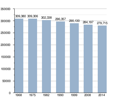
Ardennes had a population, in 2014, of 279,715,[3] for a population density of 53.5 inhabitants/km2. The arrondissement of Charleville-Mézières, with 160,939 inhabitants, is the arrondissement with more inhabitants.[8]
Evolution of the population in the Ardennes
The main communes in the department are:[8]
| City | Population (2014)[8] |
Arrondissement |
|---|---|---|
| Charleville-Mézières | 48,615 | Charleville-Mézières |
| Sedan | 17,829 | Sedan |
| Rethel | 7,778 | Rethel |
| Givet | 6,659 | Charleville-Mézières |
| Revin | 6,586 | Charleville-Mézières |
| Nouzonville | 6,107 | Charleville-Mézières |
| Bogny-sur-Meuse | 5,222 | Charleville-Mézières |
Gallery
[change | change source]-
 Charleville-Mézières on the Meuse.
 -
 Sedan, the second largest urban area of Ardennes.
 -
 Rethel, the third largest city of Ardennes.
 -


Related pages
[change | change source]References
[change | change source]- ↑ "Composition de la Commissions Permanente" (in French). Conseil Départemental des Ardennes. Retrieved 14 November 2016.
- ↑ 2.0 2.1 "Département des Ardennes (08) - Résumé statistique". Publications et statistiques pour la France ou les régions (in French). Institut national de la statistique et des études économiques - INSEE. Retrieved 14 November 2016.
- ↑ 3.0 3.1 "Populations légales 2014 des départements et des collectivités d'outre-mer" (in French). Institut national de la statistique et des études économiques - INSEE. Retrieved 4 December 2017.
- ↑ 4.0 4.1 4.2 "Historique des Ardennes". Le SPLAF (in French). Retrieved 14 November 2016.
- ↑ "La Croix Scaille, France". Peakbagger.com. Retrieved 14 November 2016.
- ↑ "Charleville-Mézières, France - Köppen Climate Classification". Weatherbase. Retrieved 14 November 2016.
- ↑ "Département des Ardennes (08)" (in French). Institut national de la statistique et des études économiques - INSEE. Retrieved 4 December 2017.
- ↑ 8.0 8.1 8.2 8.3 "Régions, départements, arrondissements, cantons et communes" (PDF). Populations légales 2014 (in French). Institut national de la statistique et des études économiques - INSEE. Retrieved 4 December 2017.
- ↑ "Département des Ardennes (08) et Arrondissements". Comparateur de territoire (in French). Institut national de la statistique et des études économiques - INSEE. Retrieved 4 December 2017.
- ↑ "Décret n° 2014-203 du 21 février 2014 portant délimitation des cantons dans le département des Ardennes" (in French). Légifrance.gouv.fr. Retrieved 14 November 2016.
- ↑ "Habitants du départment: Ardennes (08)" (in French). habitants.fr. Retrieved 14 November 2016.
Other websites
[change | change source]- General Council website (in French)
- Prefecture website (in French)
- Voie verte Trans-Ardennes
Text is available under the CC BY-SA 4.0 license; additional terms may apply.
Images, videos and audio are available under their respective licenses.
