For faster navigation, this Iframe is preloading the Wikiwand page for ගොනුව:Sri Lanka Southern Province locator map.svg.

ගොනුව:Sri Lanka Southern Province locator map.svg
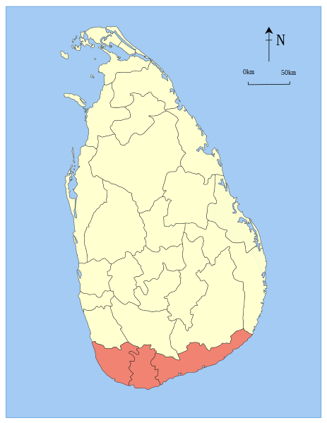
මුල් ගොනුව(SVG ගොනුව, නාමමාත්‍රිකව 612 × 792 පික්සල්, ගොනු විශාලත්වය: 394 කි.බ.)

මෙම ගොනුව Wikimedia Commons වෙතින් වන අතර අනෙකුත් ව්‍යාපෘතීන් විසින්ද භාවිතා කල හැක. එහි ගොනු විස්තර පිටුව තුල අඩංගු විස්තර මෙහි පහත දැක්වෙයි.

w:en:Creative Commons
attribution share alike
මෙම ගොනුව නිර්මාණශීලී පොදුවූවන් Attribution-Share Alike 2.5 Generic බලපත්‍රය යටතේ අවසර ලබා ඇත.
ඔබ නිදහස්:
  • බෙදාහදා ගැනීමට – කාර්යය පිටපත් කිරීමට,බෙදා හැරීමට සහ සම්ප්‍රේෂණය කිරීමට
  • නැවත සංකලනය කිරීමට – කාර්යයට අනුවර්තනය වීමට
පහත කොන්දේසිවලට යටත්ව:
  • attribution – වරපත වෙත බැඳියක්ද සපයමින් ඔබ විසින් සුදුසු කර්තෘභාරය ප්‍රදානය කල යුතු අතර, කිසියම් වෙනස්වීම් සිදුකලේ නම් එයද සඳහන් කල යුතු වෙයි. ඕනෑම සුදුසු ආකාරයට මෙය ඔබ විසින් සිදුකල හැකි මුත්, වරපත්දායකයා විසින් ඔබ හෝ ඔබගේ භාවිතය හෝ පිටසන් කරන බවට ඇඟවෙන ලෙසින් එය සිදු නොකල යුතු වෙයි.
  • share alike – මෙම විෂය කාරණා භාවිතා කොට නැවත සංකලනය, ප්‍රතියෝජනය හෝ වැඩිදියුණුව කලේ නම්, ඉන්පසු ඔබගේ දායකත්වය ඔබ විසින් බෙදාහැරිය යුත්තේ මුල් වරපත හා සමාන ‌හෝ සංගතික හෝ වරපතක් භාවිතා කරමිනි.
විස්තරය Locator maps of the provinces Sri Lanka.
දිනය 07/08/05
මූලාශ්‍රය Based on the district locator maps of Sri Lanka by User:Trengarasu (example), who are licensed into the Public Domain. Colors used from the svg-locator maps of India (example).
කර්තෘ User:Jeroen
අවසරය
(මෙම ගොනුව නැවත භාවිතා කරමින්)
Public Domain

Captions

මෙම ගොනුව නිරූපණය කරන්නෙඑ කුමක්දැයි තනි පේළියේ පැහැදිළි කිරීමක් එක් කරන්න.

Items portrayed in this file

depicts ඉංග්‍රීසි

copyright status ඉංග්‍රීසි

copyrighted ඉංග්‍රීසි

copyright license ඉංග්‍රීසි

ගොනු ඉතිහාසය

එම අවස්ථාවෙහිදී ගොනුව පැවැති ආකාරය නැරඹීමට දිනය/වේලාව මත ක්ලික් කරන්න.

දිනය/වේලාවකුඩා-රූපයමානපරිශීලකපරිකථනය
වත්මන්15:06, 5 අගෝස්තු 2007 15:06, 5 අගෝස්තු 2007වන විට අනුවාදය සඳහා කුඩා-රූපය612 × 792 (394 කි.බ.)Jeroen((PD-user-w||Commons|Trengarasu)) ((Information |Description= Locator maps of the provinces Sri Lanka. |Source= Based on the district locator maps of Sri Lanka by User:Trengarasu (example

ගොනු භාවිතය

ගෝලීය ගොනු භාවිතය

පහත දැක්වෙන අනෙකුත් විකියන් මගින් මෙම ගොනුව භාවිතා කරයි:

මෙම ගොනුවේ තවත් ගෝලීය භාවිත බලන්න.

"https://si.wikipedia.org/wiki/ගොනුව:Sri_Lanka_Southern_Province_locator_map.svg" වෙතින් සම්ප්‍රවේශනය කෙරිණි
{{bottomLinkPreText}} {{bottomLinkText}}
ගොනුව:Sri Lanka Southern Province locator map.svg
Listen to this article

This browser is not supported by Wikiwand :(
Wikiwand requires a browser with modern capabilities in order to provide you with the best reading experience.
Please download and use one of the following browsers:

This article was just edited, click to reload
This article has been deleted on Wikipedia (Why?)

Back to homepage

Please click Add in the dialog above
Please click Allow in the top-left corner,
then click Install Now in the dialog
Please click Open in the download dialog,
then click Install
Please click the "Downloads" icon in the Safari toolbar, open the first download in the list,
then click Install
{{::$root.activation.text}}

Install Wikiwand

Install on Chrome Install on Firefox
Don't forget to rate us

Tell your friends about Wikiwand!

Gmail Facebook Twitter Link

Enjoying Wikiwand?

Tell your friends and spread the love:
Share on Gmail Share on Facebook Share on Twitter Share on Buffer

Our magic isn't perfect

You can help our automatic cover photo selection by reporting an unsuitable photo.

This photo is visually disturbing This photo is not a good choice

Thank you for helping!


Your input will affect cover photo selection, along with input from other users.

X

Get ready for Wikiwand 2.0 🎉! the new version arrives on September 1st! Don't want to wait?