For faster navigation, this Iframe is preloading the Wikiwand page for ගොනුව:PalestineAndTransjordan.png.

ගොනුව:PalestineAndTransjordan.png

PalestineAndTransjordan.png(636 × 599 පික්සල, ගොනු විශාලත්වය: 65 කි.බ., MIME ශෛලිය: image/png)

මෙම ගොනුව Wikimedia Commons වෙතින් වන අතර අනෙකුත් ව්‍යාපෘතීන් විසින්ද භාවිතා කල හැක. එහි ගොනු විස්තර පිටුව තුල අඩංගු විස්තර මෙහි පහත දැක්වෙයි.

විස්තරය
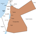
English: Map of the British Mandate of Palestine and Transjordan.
Note: Wasserstein, Bernard (2004). Israel and Palestine: Why They Fight and Can They Stop?, pp. 105–106."Palestine, therefore, was not partitioned in 1921–1922. Transjordan was not excised but, on the contrary, added to the mandatory area. Zionism was barred from seeking to expand there – but the Balfour Declaration had never previously applied to the area east of the Jordan. Why is this important? Because the myth of Palestine's 'first partition' has become part of the concept of 'Greater Israel' and of the ideology of Jabotinsky's Revisionist movement."
මූලාශ්‍රය

Originally uploaded on the English Wiki (all linking to en.wikipedia):

08:13, 8 June 2005 Doron (Talk / contribs) uploaded "Image:PalestineAndTransjordan.png"
කර්තෘ User:Doron
අවසරය
(මෙම ගොනුව නැවත භාවිතා කරමින්)
GNU head Free Software Foundation විසින් ප්‍රකාශිත GNU Free Documentation License බලපත්‍රයෙහි 1.2 හෝ ඊට අලුත් පිටපත්වල කොන්දේසිවලට යටත්ව මෙම ගොනුව පිටපත් කෙරුමට, නැවත බෙදාහාරුමට සහ/හෝ වෙනස් කෙරුමට අවසර දී ඇත; ඒ වෙනස් අංශ නොමැතිව, මුල් පිටු පෙළ නොමැතිව, පසු පිටු පෙළ නොමැතිවය. බලපත්‍රයේ පිටපතක් GNU Free Documentation License නම් අංශයේ දැක්වේ.
w:en:Creative Commons
attribution share alike
මෙම ගොනුව ක්‍රියේටිව් කොමන්ස් Attribution-Share Alike 3.0 Unported වරපත යටතේ අවසර ලබා ඇත.
ඔබ නිදහස්:
  • බෙදාහදා ගැනීමට – කාර්යය පිටපත් කිරීමට,බෙදා හැරීමට සහ සම්ප්‍රේෂණය කිරීමට
  • නැවත සංකලනය කිරීමට – කාර්යයට අනුවර්තනය වීමට
පහත කොන්දේසිවලට යටත්ව:
  • attribution – වරපත වෙත බැඳියක්ද සපයමින් ඔබ විසින් සුදුසු කර්තෘභාරය ප්‍රදානය කල යුතු අතර, කිසියම් වෙනස්වීම් සිදුකලේ නම් එයද සඳහන් කල යුතු වෙයි. ඕනෑම සුදුසු ආකාරයට මෙය ඔබ විසින් සිදුකල හැකි මුත්, වරපත්දායකයා විසින් ඔබ හෝ ඔබගේ භාවිතය හෝ පිටසන් කරන බවට ඇඟවෙන ලෙසින් එය සිදු නොකල යුතු වෙයි.
  • share alike – මෙම විෂය කාරණා භාවිතා කොට නැවත සංකලනය, ප්‍රතියෝජනය හෝ වැඩිදියුණුව කලේ නම්, ඉන්පසු ඔබගේ දායකත්වය ඔබ විසින් බෙදාහැරිය යුත්තේ මුල් වරපත හා සමාන ‌හෝ සංගතික හෝ වරපතක් භාවිතා කරමිනි.
GFDL බලපත්‍ර යාවත්කාල කෙරුමහි කොටසක් ලෙස මෙම ගොනුවට බලපත්‍ර ටැගය එක් කෙරිනි.
අනෙකුත් අනුවාදයන් Image:BritishMandatePalestine1920.png

Captions

මෙම ගොනුව නිරූපණය කරන්නෙඑ කුමක්දැයි තනි පේළියේ පැහැදිළි කිරීමක් එක් කරන්න.

Items portrayed in this file

depicts ඉංග්‍රීසි

copyright status ඉංග්‍රීසි

copyrighted ඉංග්‍රීසි

copyright license ඉංග්‍රීසි

ගොනු ඉතිහාසය

එම අවස්ථාවෙහිදී ගොනුව පැවැති ආකාරය නැරඹීමට දිනය/වේලාව මත ක්ලික් කරන්න.

දිනය/වේලාවකුඩා-රූපයමානපරිශීලකපරිකථනය
වත්මන්15:17, 22 මාර්තු 2019 15:17, 22 මාර්තු 2019වන විට අනුවාදය සඳහා කුඩා-රූපය636 × 599 (65 කි.බ.)Claude ZygielThis file in clearly definite as "Map of the British Mandate of Palestine '''and''' Transjordan" and used for the both territories
12:01, 24 ඔක්තෝබර් 2017 12:01, 24 ඔක්තෝබර් 2017වන විට අනුවාදය සඳහා කුඩා-රූපය636 × 599 (61 කි.බ.)Nicola RomaniReverted to version as of 11:02, 22 April 2016 (UTC)
17:04, 30 අගෝස්තු 2017 17:04, 30 අගෝස්තු 2017වන විට අනුවාදය සඳහා කුඩා-රූපය675 × 542 (51 කි.බ.)OnceinawhileConverted into new svg - this is the png version
16:07, 19 ඔක්තෝබර් 2016 16:07, 19 ඔක්තෝබර් 2016වන විට අනුවාදය සඳහා කුඩා-රූපය636 × 599 (65 කි.බ.)Claude ZygielThis file in clearly definite as "Map of the British Mandate of Palestine '''and''' Transjordan" and used for the both territories.
11:02, 22 අප්‍රේල් 2016 11:02, 22 අප්‍රේල් 2016වන විට අනුවාදය සඳහා කුඩා-රූපය636 × 599 (61 කි.බ.)Makeandtossoops
11:01, 22 අප්‍රේල් 2016 11:01, 22 අප්‍රේල් 2016වන විට අනුවාදය සඳහා කුඩා-රූපය636 × 599 (61 කි.බ.)MakeandtossRemoved Mandatory Palestine since picture is used to refer to only the emirate
15:49, 4 දෙසැම්බර් 2011 15:49, 4 දෙසැම්බර් 2011වන විට අනුවාදය සඳහා කුඩා-රූපය636 × 599 (66 කි.බ.)Wickey-nlthicker lining around lake
21:43, 3 දෙසැම්බර් 2011 21:43, 3 දෙසැම්බර් 2011වන විට අනුවාදය සඳහා කුඩා-රූපය636 × 599 (66 කි.බ.)Wickey-nlFixed border
15:29, 29 ජනවාරි 2011 15:29, 29 ජනවාරි 2011වන විට අනුවාදය සඳහා කුඩා-රූපය636 × 599 (77 කි.බ.)VadacFixed border of Transjordan within the Mandate of Palestine with Saudi Arabia per the present border having been drawn in 1965 as seen here.
11:29, 24 පෙබරවාරි 2006 11:29, 24 පෙබරවාරි 2006වන විට අනුවාදය සඳහා කුඩා-රූපය636 × 599 (89 කි.බ.)Lohen11Palestine from:

ගොනු භාවිතය

පහත දැක්වෙන පිටුව විසින් මෙම ගොනුව භාවිතා කෙරෙයි:

ගෝලීය ගොනු භාවිතය

පහත දැක්වෙන අනෙකුත් විකියන් මගින් මෙම ගොනුව භාවිතා කරයි:

මෙම ගොනුවේ තවත් ගෝලීය භාවිත බලන්න.

පාරදත්ත

"https://si.wikipedia.org/wiki/ගොනුව:PalestineAndTransjordan.png" වෙතින් සම්ප්‍රවේශනය කෙරිණි
{{bottomLinkPreText}} {{bottomLinkText}}
ගොනුව:PalestineAndTransjordan.png
Listen to this article

This browser is not supported by Wikiwand :(
Wikiwand requires a browser with modern capabilities in order to provide you with the best reading experience.
Please download and use one of the following browsers:

This article was just edited, click to reload
This article has been deleted on Wikipedia (Why?)

Back to homepage

Please click Add in the dialog above
Please click Allow in the top-left corner,
then click Install Now in the dialog
Please click Open in the download dialog,
then click Install
Please click the "Downloads" icon in the Safari toolbar, open the first download in the list,
then click Install
{{::$root.activation.text}}

Install Wikiwand

Install on Chrome Install on Firefox
Don't forget to rate us

Tell your friends about Wikiwand!

Gmail Facebook Twitter Link

Enjoying Wikiwand?

Tell your friends and spread the love:
Share on Gmail Share on Facebook Share on Twitter Share on Buffer

Our magic isn't perfect

You can help our automatic cover photo selection by reporting an unsuitable photo.

This photo is visually disturbing This photo is not a good choice

Thank you for helping!


Your input will affect cover photo selection, along with input from other users.

X

Get ready for Wikiwand 2.0 🎉! the new version arrives on September 1st! Don't want to wait?