ගොනුව:Map of Vedic India.png
මෙයට ඉහල විසර්ජනයක් ලබාගත නොහැක.
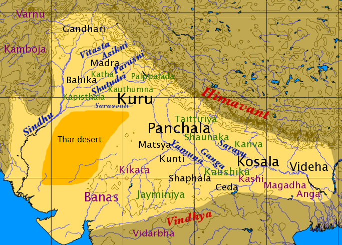
Map_of_Vedic_India.png (683 × 489 පික්සල, ගොනු විශාලත්වය: 424 කි.බ., MIME ශෛලිය: image/png)
මෙම කෘතියෙහි හිමිකම් අයිතීන් දරන්නා වන Dbachmann නමැති මම, පහත වරපත යටතේ එය ප්රකාශයට පත් කරමි:

|
Free Software Foundation විසින් ප්රකාශිත GNU Free Documentation License බලපත්රයෙහි 1.2 හෝ ඊට අලුත් පිටපත්වල කොන්දේසිවලට යටත්ව මෙම ගොනුව පිටපත් කෙරුමට, නැවත බෙදාහාරුමට සහ/හෝ වෙනස් කෙරුමට අවසර දී ඇත; ඒ වෙනස් අංශ නොමැතිව, මුල් පිටු පෙළ නොමැතිව, පසු පිටු පෙළ නොමැතිවය. බලපත්රයේ පිටපතක් GNU Free Documentation License නම් අංශයේ දැක්වේ. |
| මෙම ගොනුව ක්රියේටිව් කොමන්ස් Attribution-Share Alike 3.0 Unported වරපත යටතේ අවසර ලබා ඇත. | ||
| Attribution: Dbachmann | ||
| ||
| GFDL බලපත්ර යාවත්කාල කෙරුමහි කොටසක් ලෙස මෙම ගොනුවට බලපත්ර ටැගය එක් කෙරිනි. |
derivative works
Derivative works of this file: Map of Vedic India ru.png
ගොනු ඉතිහාසය
එම අවස්ථාවෙහිදී ගොනුව පැවැති ආකාරය නැරඹීමට දිනය/වේලාව මත ක්ලික් කරන්න.
| දිනය/වේලාව | කුඩා-රූපය | මාන | පරිශීලක | පරිකථනය | |
|---|---|---|---|---|---|
| වත්මන් | 13:59, 18 පෙබරවාරි 2016 | | 683 × 489 (424 කි.බ.) | Mywikicommons | Reverted to version as of 13:48, 18 February 2016 (UTC) |
| 13:59, 18 පෙබරවාරි 2016 |  | 683 × 489 (424 කි.බ.) | Mywikicommons | Reupload - Minor addition : Thar Desert (text) added to map according to already given sources. | |
| 13:48, 18 පෙබරවාරි 2016 |  | 683 × 489 (424 කි.බ.) | Mywikicommons | Minor addition : Thar Desert (text) added to map according to already given sources. | |
| 11:04, 22 අගෝස්තු 2005 |  | 683 × 489 (353 කි.බ.) | Dbachmann | by en:User:Dbachmann ((GFDL)) |
ගොනු භාවිතය
පහත දැක්වෙන පිටු 2 ක් විසින් මෙම ගොනුව භාවිතා කෙරෙයි:
ගෝලීය ගොනු භාවිතය
පහත දැක්වෙන අනෙකුත් විකියන් මගින් මෙම ගොනුව භාවිතා කරයි:
- af.wikipedia.org හි භාවිතය
- als.wikipedia.org හි භාවිතය
- anp.wikipedia.org හි භාවිතය
- ar.wikipedia.org හි භාවිතය
- ast.wikipedia.org හි භාවිතය
- az.wikipedia.org හි භාවිතය
- bg.wikipedia.org හි භාවිතය
- bh.wikipedia.org හි භාවිතය
- bn.wikipedia.org හි භාවිතය
- ca.wikipedia.org හි භාවිතය
- cs.wikipedia.org හි භාවිතය
- de.wikipedia.org හි භාවිතය
- el.wikipedia.org හි භාවිතය
- en.wikipedia.org හි භාවිතය
මෙම ගොනුවේ තවත් ගෝලීය භාවිත බලන්න.
පාරදත්ත
Text is available under the CC BY-SA 4.0 license; additional terms may apply.
Images, videos and audio are available under their respective licenses.
Cover photo is available under {{::mainImage.info.license.name || 'Unknown'}} license.
Cover photo is available under {{::mainImage.info.license.name || 'Unknown'}} license.
Credit:
(see original file).
