ගොනුව:Adams bridge map.png
Adams_bridge_map.png (519 × 239 පික්සල, ගොනු විශාලත්වය: 25 කි.බ., MIME ශෛලිය: image/png)
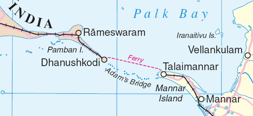
Map of en:Adam's Bridge, India/Sri Lanka
Extracted from www.un.org/Depts/Cartographic/map/profile/srilanka.pdf
| This image is a map derived from a United Nations map.
Unless stated otherwise, UN maps are to be considered in the public domain. This applies worldwide. UN maps are, in principle, open source material and you can use them in your work or for making your own map. UN requests however that you delete the UN name, logo and reference number upon any modification to the map. Content of your map will be your responsibility. You can state in your publication, if you wish, something like: based on UN map … (map name, map number, revision number and date). See: Geospatial Information Section. And: Geospatial, location data for a better world. |
 |
ගොනු ඉතිහාසය
එම අවස්ථාවෙහිදී ගොනුව පැවැති ආකාරය නැරඹීමට දිනය/වේලාව මත ක්ලික් කරන්න.
| දිනය/වේලාව | කුඩා-රූපය | මාන | පරිශීලක | පරිකථනය | |
|---|---|---|---|---|---|
| වත්මන් | 01:55, 4 අගෝස්තු 2006 | | 519 × 239 (25 කි.බ.) | Gugganij | Map of Adam's Bridge, India/Sri Lanka Extracted from http://www.un.org/Depts/Cartographic/map/profile/srilanka.pdf ((UN map)) |
ගොනු භාවිතය
පහත දැක්වෙන පිටු 3 ක් විසින් මෙම ගොනුව භාවිතා කෙරෙයි:
ගෝලීය ගොනු භාවිතය
පහත දැක්වෙන අනෙකුත් විකියන් මගින් මෙම ගොනුව භාවිතා කරයි:
- ar.wikipedia.org හි භාවිතය
- az.wikipedia.org හි භාවිතය
- ba.wikipedia.org හි භාවිතය
- be.wikipedia.org හි භාවිතය
- bn.wikipedia.org හි භාවිතය
- cs.wikipedia.org හි භාවිතය
- de.wikipedia.org හි භාවිතය
- el.wikipedia.org හි භාවිතය
- en.wikipedia.org හි භාවිතය
- eo.wikipedia.org හි භාවිතය
- es.wikipedia.org හි භාවිතය
- et.wikipedia.org හි භාවිතය
- fi.wikipedia.org හි භාවිතය
- fr.wikipedia.org හි භාවිතය
- fy.wikipedia.org හි භාවිතය
- gl.wikipedia.org හි භාවිතය
- gu.wikipedia.org හි භාවිතය
- he.wikipedia.org හි භාවිතය
- hi.wikipedia.org හි භාවිතය
- hu.wikipedia.org හි භාවිතය
- id.wikipedia.org හි භාවිතය
- it.wikipedia.org හි භාවිතය
- ja.wikipedia.org හි භාවිතය
- kn.wikipedia.org හි භාවිතය
- ko.wikipedia.org හි භාවිතය
- la.wikipedia.org හි භාවිතය
- lt.wikipedia.org හි භාවිතය
- mai.wikipedia.org හි භාවිතය
- mk.wikipedia.org හි භාවිතය
- ml.wikipedia.org හි භාවිතය
මෙම ගොනුවේ තවත් ගෝලීය භාවිත බලන්න.
Text is available under the CC BY-SA 4.0 license; additional terms may apply.
Images, videos and audio are available under their respective licenses.
