فائل:Naddniestrze.png
هن پيش-نگاھ جي ماپ: 420*599 پڪزلس. ٻيا تحلل:168*240 پڪزلس | 336*480 پڪزلس | 538*768 پڪزلس | 718*1,024 پڪزلس | 1,436*2,048 پڪزلس | 2,655*3,786 پڪزلس
اصلوڪو فائيل (2,655 × 3,786 عڪسلون، فائيل سائيز: 5.13 MB، MIME ٽائيپ: image/png)
تَتُ
| تشريح |
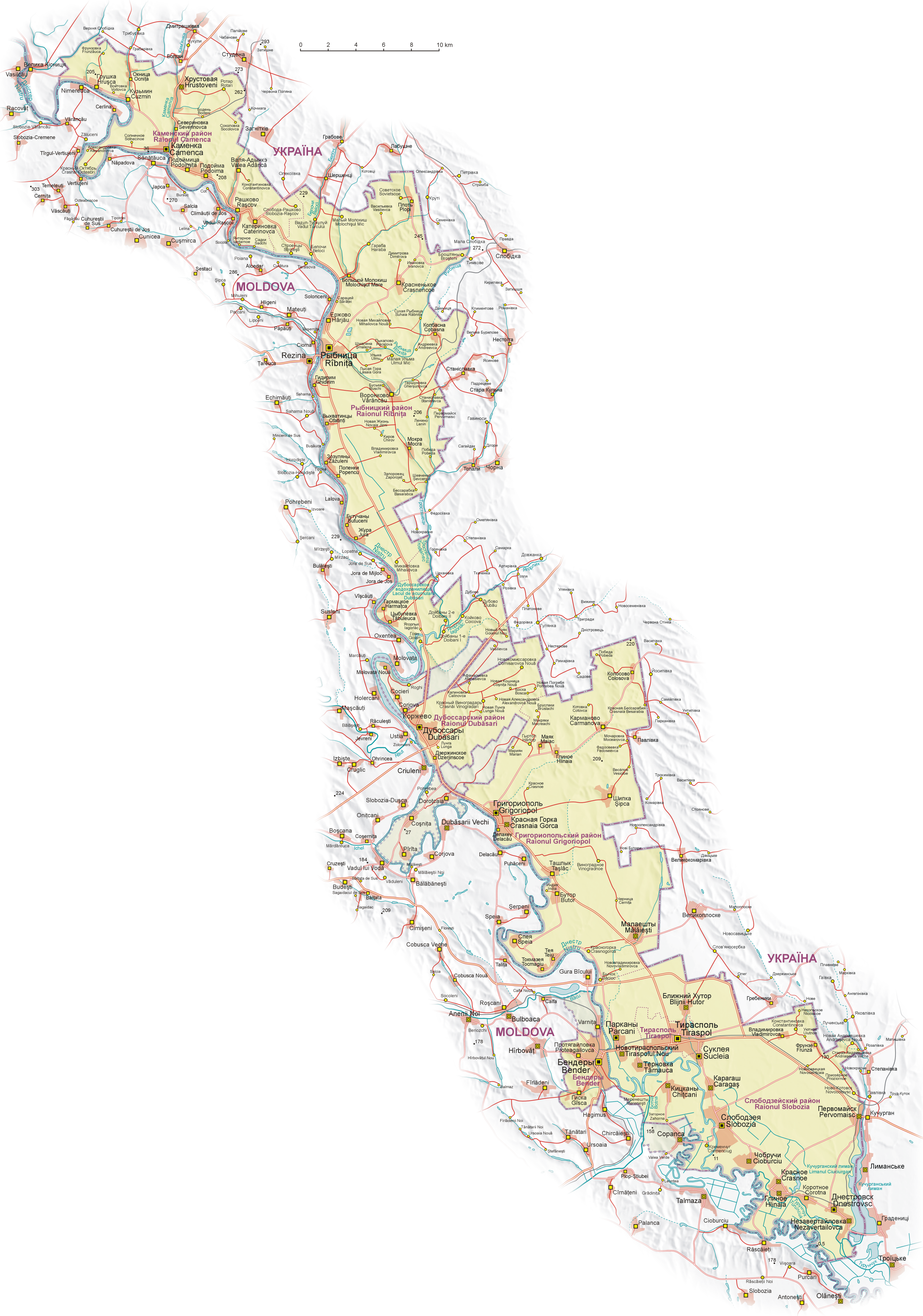
English: Map of Transnistria (with claimed area), based on Soviet and Ukrainian topographic map, and Shuttle Radar Topography Mission (STRM).
Geographical names:
 Polski: Mapa Naddniestrza (wraz z obszarem roszczeń). Mapa opracowana na podstawie radzieckich map topograficznych w skali 1:100 000 z końca lat 80. oraz ukraińskich map topograficznych z lat 2002-2006, rzeźba terenu wygenerowana na podstawie danych Shuttle Radar Topography Mission (STRM) udostępnionych przez United States Geological Survey.
Nazewnictwo geograficzne:
 Español: Mapa de Transnistria, basado en mapas topográficos soviéticos y ucranianos, y en la STRM. Nombres geográficos:
|
| تاريخ | |
| ذريعو | ڪم پنھنجايو |
| ليکڪ | Aotearoa |
| Other versions |
|


.png)


لائيسنسڪاري
I, the copyright holder of this work, hereby publish it under the following licenses:

|
ھن دستاويز کي جي.اين.يو مفت دستاويزسازي اجازتنامي ، مفت سافٽويئر فائونڊيشن پاران ڇاپيل ورزن 1.2 يا ٻي ڪنھن بعد واري ورزن؛ جنھن ۾ نہ انويريئينٽ ڀاڱا، ۽ نہ فونٽ-ڪور متنَ، ۽ نہ بيڪ-ڪور متنَ شامل آھن، جي شرطن ھيٺ نقل ڪرڻ، ورھائن ۽/يا بدلائڻ جي اجازت ڏني وئي آھي. اجازتنامي جو نقل [[c:Commons:GNU Free Documentation License, version 1.2 | جي.اين.يو مفت دستاويزسازي اجازتنامو]] نالي ڀاڱي ۾ ڏنل آھي. |
| ھي فائيل ڪريئيٽو ڪامنز انتساب-ھڪجھڙي ڀاڱيداري 3.0 انپورٽڊ اجازتنامي ھيٺ اجازتنامو ڏنل آھي. | ||
| ||
| This licensing tag was added to this file as part of the GFDL licensing update. |
توھان پنھنجي پسند جو اجازتنامو چونڊي سگهو ٿا.
|
This image has been assessed using the Quality image guidelines and is considered a Quality image.
|
فائيل جي سوانح
ڪنھن بہ تاريخ/وقت تي ٽڙڪ ڪري ڏسندا تہ ان وقت اهو فائيل ڪيئن هو.
| تاريخ/وقت | ٽِڪِلِي | ماپَ | واپرائيندڙ | راءِ | |
|---|---|---|---|---|---|
| هاڻوڪو نسخو | 05:08, 27 جُولاءِ 2011 | | 2,655 × 3,786 (5.13 MB) | Nicolay Sidorov | + русское название села Коржево, исправил название села Zahorna - Загорное, а не "Захорна" |
| 10:18, 14 سيپٽمبر 2008 |  | 2,655 × 3,786 (5.21 MB) | Aotearoa | ((Information |Description= |Source= |Date= |Author= |Permission= |other_versions= )) | |
| 20:01, 25 آگسٽ 2008 |  | 2,655 × 3,790 (5.62 MB) | Aotearoa | ((Information |Description= |Source= |Date= |Author= |Permission= |other_versions= )) | |
| 19:39, 25 آگسٽ 2008 |  | 2,962 × 4,230 (6.21 MB) | Aotearoa | ((Information |Description= |Source= |Date= |Author= |Permission= |other_versions= )) | |
| 19:27, 25 آگسٽ 2008 |  | 3,054 × 4,271 (6.22 MB) | Aotearoa | ((Information |Description= |Source= |Date= |Author= |Permission= |other_versions= )) | |
| 18:51, 25 آگسٽ 2008 |  | 3,054 × 4,271 (6.22 MB) | Aotearoa | ((Information |Description=((en|1=Map of Transnistria, based on Soviet and Ucrainian topographic map, and Shuttle Radar Topography Mission (STRM). Names in Transnistria according Transnistrian government)) ((pl|1= |
ڳنڍڻا
هن فائيل سان هيٺيان صفحا ڳنڍيل آهن.
فائيل جو ٻين وڪيز تي استعمال
ھيٺيون وڪيز بہ ھيءُ فائيل استعمال ڪن ٿيون:
- ast.wikipedia.org تي استعمال
- ca.wikipedia.org تي استعمال
- cs.wikipedia.org تي استعمال
- de.wikipedia.org تي استعمال
- en.wikipedia.org تي استعمال
- eo.wikipedia.org تي استعمال
- eu.wikipedia.org تي استعمال
- fr.wikipedia.org تي استعمال
- fr.wikinews.org تي استعمال
- gl.wikipedia.org تي استعمال
- he.wikipedia.org تي استعمال
- hu.wikipedia.org تي استعمال
- is.wikipedia.org تي استعمال
- ja.wikipedia.org تي استعمال
- li.wikipedia.org تي استعمال
- ml.wikipedia.org تي استعمال
- nl.wikipedia.org تي استعمال
- pa.wikipedia.org تي استعمال
- pl.wikipedia.org تي استعمال
- Wikipedysta:Aotearoa/brudnopis
- Wikipedia:Ilustracje na Medal/rysunki i animacje
- Wikipedia:Propozycje do Ilustracji na Medal/Naddniestrze.png
- Dyskusja pliku:Naddniestrze.png
- Wikipedysta:Aotearoa/mapy
- Szablon:Ilustracja na medal/2011-09-02
- Szablon:Ilustracja na medal/2012-02-14
- Szablon:Ilustracja na medal/2013-02-10
- Szablon:Ilustracja na medal/2014-08-16
- Wikipedysta:The Polish/Nieużywane szablony/Ilustracja na medal/1-500
- Wikipedysta:The Polish/Nieużywane szablony/Ilustracja na medal/501-1000
- Wikipedysta:The Polish/Nieużywane szablony/Ilustracja na medal/1001-1500
- ro.wikipedia.org تي استعمال
- ru.wikipedia.org تي استعمال
- sr.wikipedia.org تي استعمال
- su.wikipedia.org تي استعمال
ھن فائيل جو وڌيڪ گلوبل استعمال ڏسو.
Text is available under the CC BY-SA 4.0 license; additional terms may apply.
Images, videos and audio are available under their respective licenses.
Cover photo is available under {{::mainImage.info.license.name || 'Unknown'}} license.
Cover photo is available under {{::mainImage.info.license.name || 'Unknown'}} license.
Credit:
(see original file).
