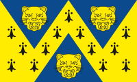
Shropshire
| Shropshire | |||
|---|---|---|---|
| Coonty | |||
| |||
| Motto: "Floreat Salopia" ("Mey Shropshire flourish") | |||
 | |||
| Coordinates: 52°37′N 2°43′W / 52.617°N 2.717°WCoordinates: 52°37′N 2°43′W / 52.617°N 2.717°W | |||
| Sovereign state | Unitit Kinrick | ||
| Constituent kintra | Ingland | ||
| Region | Wast Midlands | ||
| Established | Auncient | ||
| Ceremonial coonty | |||
| Laird Lieutenant | Algernon Eustace Heber-Percy | ||
| Heich Shirra | Rhoderick M Swire [1] (2018/19) | ||
| Area | 3,487 km2 (1,346 sq mi) | ||
| • Rankit | 13t o 48 | ||
| Population (2011 est.) | 456,000 | ||
| • Rankit | 42nt o 48 | ||
| Density | 131/km2 (340/sq mi) | ||
| Ethnicity | Figures for Shropshire UA:[2] 93.8% White, Breetish 1.9% White, ither 1.5% S. Asie 0.9% Mixed 0.6% White, Erse 0.6% Black | ||
| Unitar authority | |||
| Cooncil | Shropshire Council | ||
| Executive | Conservative | ||
| Admin HQ | Shrewsbury | ||
| Aurie | 3,197 km2 (1,234 sq mi) | ||
| • Rankit | 4t o 326 | ||
| Population | 323,606 | ||
| • Rankit | 33rd o 326 | ||
| Density | 96/km2 (250/sq mi) | ||
| ISO 3166-2 | GB-SHR | ||
| ONS code | 00GG | ||
| GSS code | E06000051 | ||
| NUTS | UKG22 | ||
| Wabsteid | www | ||
 Destricts o Shropshire Unitar | |||
| Destricts |
| ||
| Members o Pairlament | Leet o MPs | ||
| Polis | West Mercia Police | ||
| Time zone | Greenwich Mean Time (UTC) | ||
| • Simmer (DST) | Breetish Simmer Time (UTC+1) | ||
Shropshire (/[unsupported input]ˈʃrɒpʃər/ or /ˈʃrɒpʃɪər/; alternatively Salop;[3] abbreviated, in print only, Shrops[4]) is a coonty in the Wast Midlands region o Ingland. It borders Wales tae the wast, Cheshire tae the north, Staffordshire tae the east, Worcestershire tae the sooth-east an Herefordshire tae the sooth. A unitary authority (Shropshire Council) wis creatit on 1 Aprile 2009, takkin ower frae the previous coonty cooncil an 5 destrict cooncils, an covers maist o the coonty. The burgh o Telford an Wrekin, includit in Shropshire for ceremonial purposes, haes been a separate unitary authority syne 1998.[5]
References
[eedit | eedit soorce]- ↑ "No. 62229". The London Gazette. 15 Mairch 2018. pp. 4814–4814.
- ↑ Rogers, Simon (19 Mey 2011). "Ethnic breakdown of England and Wales mapped". The Guardian.
- ↑ Blandings: English Counties – broken link
- ↑ SHROPS – What does SHROPS stand for? Acronyms and abbreviations by the Free Online Dictionary. Acronyms.thefreedictionary.com. Retrieved on 25 August 2011.
- ↑ statics.gov website[deid airtin]
Freemit airtins
[eedit | eedit soorce]Template:Shropshire
Template:Wast Midlands Template:Unitary authorities o Ingland
Text is available under the CC BY-SA 4.0 license; additional terms may apply.
Images, videos and audio are available under their respective licenses.

