Файл:European railtrafficregions.png
Материал из Википедии — свободной энциклопедии
Размер этого предпросмотра: 683 × 599 пкс. Другие разрешения: 274 × 240 пкс | 547 × 480 пкс | 891 × 782 пкс.
Исходный файл (891 × 782 пкс, размер файла: 28 КБ, MIME-тип: image/png)
Этот файл находится на Викискладе. Сведения о нём показаны ниже.
Викисклад — централизованное хранилище для свободных файлов, используемых в проектах Викимедиа.
|
| Описание |
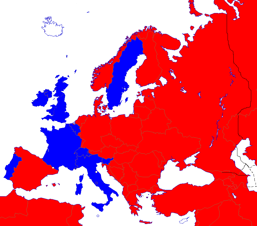
English: Right- and left-hand traffic on European railways.
Right-hand traffic Left-hand traffic No railway Svenska: Höger- och vänstertrafik på järnvägar i Europa. Högertrafik Vänstertrafik Inga järnvägar |
||||||||
| Дата | |||||||||
| Источник | Wikipedia | ||||||||
| Автор | Paul Schlyter | ||||||||
| Права (Повторное использование этого файла) |
|
||||||||
| Другие версии |
File:European_trafficregions.png |


|
Это изображение неизвестного типа «map of europe» желательно воссоздать или аккуратно преобразовать в векторный формат SVG. Это даёт несколько преимуществ, прочитать о которых подробнее вы можете на странице Commons:Media for cleanup. Если вам уже сейчас доступна векторная версия данного изображения, загрузите её, пожалуйста, а затем замените этот шаблон на следующий: ((Vector version available|Имя загруженного файла.svg)).
|
История файла
Нажмите на дату/время, чтобы посмотреть файл, который был загружен в тот момент.
| Дата/время | Миниатюра | Размеры | Участник | Примечание | |
|---|---|---|---|---|---|
| текущий | 22:06, 23 августа 2022 | | 891 × 782 (28 КБ) | Рагин1987 | More correct visualization of the dividing line on the territory of the Caucasus Range |
| 16:24, 15 декабря 2017 |  | 891 × 782 (44 КБ) | A2D2 | The Vatican city has railways and uses the left just like Italy, even though it is only a few hundred meters long and is very rarely used. | |
| 20:30, 18 января 2017 |  | 891 × 782 (44 КБ) | BIL | Spain uses right. Austria also to much higher degree since 2012. Monaco uses left. A corner of France and Sweden diverge use their neighbour's side. Channel tunnel and Oresund Bridge added. Slightly cropped so that Svalbard and Turkmenistan are excluded. | |
| 14:22, 1 сентября 2008 |  | 942 × 917 (44 КБ) | Pausch | ((Information/sv |Beskrivning = Höger/vänstertrafik på järnvägar i Europa |Källa = Wikipedia |Datum = 2008-09-01 |Skapare = Paul Schlyter |Rättigheter = GFDL |Andra_versioner = European_trafficregions.png )) Category:Järnvägar <!--((ImageUpl |
Использование файла
Следующая страница использует этот файл:
Глобальное использование файла
Данный файл используется в следующих вики:
- Использование в en.wikipedia.org
- Использование в es.wikipedia.org
- Использование в et.wikipedia.org
- Использование в hu.wikipedia.org
- Использование в id.wikipedia.org
- Использование в mk.wikipedia.org
- Использование в no.wikipedia.org
- Использование в sv.wikipedia.org
- Использование в www.wikidata.org
Метаданные
Text is available under the CC BY-SA 4.0 license; additional terms may apply.
Images, videos and audio are available under their respective licenses.
Cover photo is available under {{::mainImage.info.license.name || 'Unknown'}} license.
Cover photo is available under {{::mainImage.info.license.name || 'Unknown'}} license.
Credit:
(see original file).
