For faster navigation, this Iframe is preloading the Wikiwand page for Файл:Asia Europe transcontinental.png.

Файл:Asia Europe transcontinental.png

Материал из Википедии — свободной энциклопедии
Исходный файл(1268 × 996 пкс, размер файла: 46 КБ, MIME-тип: image/png)

Описание
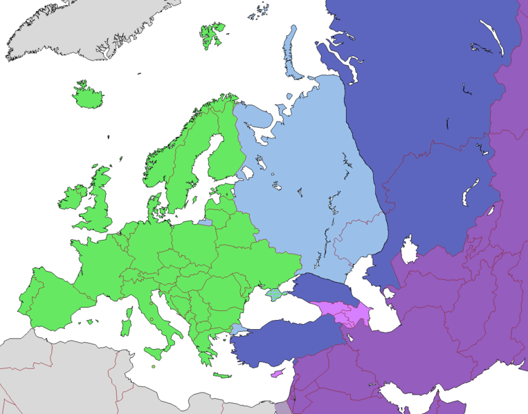
English: Map of Europe, indicating continental boundary (by Britannica and Great Soviet Encyclopedia) and transcontinental states.
 
States geographically in Europe (excepting overseas possessions)
 
Transcontinental states, European territory
 
Transcontinental states, Asian territory
 
Asian countries, sometimes referred to as Europe according to political, economic, and historical and cultural criteria (Azerbaijan, Armenia, Georgia, Cyprus)
 
Geographically Asian states (island states of Cyprus and Bahrain usually grouped with Asia geographically)
 
Asian part of Egypt
Русский: Карта Европы с указанием границ частей света (по БСЭ и Британнике) и трансконтинентальных государств.
 
Государства, расположенные в Европе (за исключением заморских владений)
 
Трансконтинентальные государства, европейская территория
 
Трансконтинентальные государства, азиатская территория
 
Государства Азии, иногда относимые к Европе по политическим, экономическим, и историко-культурным критериям
 
Государства, расположенные в Азии
 
Азиатская часть Египта
Дата
Источник
Автор

Лицензирование

w:ru:Creative Commons
атрибуция распространение на тех же условиях
Этот файл доступен по лицензии Creative Commons Attribution-Share Alike 3.0 Unported.
Вы можете свободно:
  • делиться произведением – копировать, распространять и передавать данное произведение
  • создавать производные – переделывать данное произведение
При соблюдении следующих условий:
  • атрибуция – Вы должны указать авторство, предоставить ссылку на лицензию и указать, внёс ли автор какие-либо изменения. Это можно сделать любым разумным способом, но не создавая впечатление, что лицензиат поддерживает вас или использование вами данного произведения.
  • распространение на тех же условиях – Если вы изменяете, преобразуете или создаёте иное произведение на основе данного, то обязаны использовать лицензию исходного произведения или лицензию, совместимую с исходной.
Аннотации
InfoField
Это изображение аннотировано: Просмотреть аннотации на Викискладе

Краткие подписи

Добавьте однострочное описание того, что собой представляет этот файл

Элементы, изображённые на этом файле

изображённый объект

image/png

996 пиксель

1268 пиксель

История файла

Нажмите на дату/время, чтобы посмотреть файл, который был загружен в тот момент.

Дата/времяМиниатюраРазмерыУчастникПримечание
текущий10:23, 14 ноября 2022Миниатюра для версии от 10:23, 14 ноября 20221268 × 996 (46 КБ)Рагин1987Highlighted with a light purple hue the countries of Asia, sometimes attributed to Europe according to political, economic, and historical and cultural criteria (Transcaucasia, Cyprus).
12:02, 29 августа 2022Миниатюра для версии от 12:02, 29 августа 20221268 × 996 (46 КБ)Рагин1987Small correction
07:03, 18 февраля 2020Миниатюра для версии от 07:03, 18 февраля 20201268 × 996 (56 КБ)Insiderfix: mixed color. not dark blue
06:55, 18 февраля 2020Миниатюра для версии от 06:55, 18 февраля 20201268 × 996 (60 КБ)InsiderReverted to version as of 07:01, 13 October 2014 (UTC) Crimea that is Europe
09:04, 10 февраля 2020Миниатюра для версии от 09:04, 10 февраля 20201268 × 996 (84 КБ)Compu wikiКрым — это Россия. Crimea is Russia.
07:01, 13 октября 2014Миниатюра для версии от 07:01, 13 октября 20141268 × 996 (60 КБ)InsiderReverted to version as of 10:10, 1 July 2014 Crimea that is Europe
12:31, 11 октября 2014Миниатюра для версии от 12:31, 11 октября 20141268 × 996 (84 КБ)Michael1238Crimea
10:10, 1 июля 2014Миниатюра для версии от 10:10, 1 июля 20141268 × 996 (60 КБ)Insider((Information |Description=((en|1= Map of Europe, indicating continental boundary and transcontinental states. ((legend|#67e836|States geographically in Europe (excepting overseas possessions; island states UK, Ireland, Iceland and Malta usually group...

Использование файла

Следующие 2 страницы используют этот файл:

Глобальное использование файла

Данный файл используется в следующих вики:

Метаданные

{{bottomLinkPreText}} {{bottomLinkText}}
Файл:Asia Europe transcontinental.png
Listen to this article

This browser is not supported by Wikiwand :(
Wikiwand requires a browser with modern capabilities in order to provide you with the best reading experience.
Please download and use one of the following browsers:

This article was just edited, click to reload
This article has been deleted on Wikipedia (Why?)

Back to homepage

Please click Add in the dialog above
Please click Allow in the top-left corner,
then click Install Now in the dialog
Please click Open in the download dialog,
then click Install
Please click the "Downloads" icon in the Safari toolbar, open the first download in the list,
then click Install
{{::$root.activation.text}}

Install Wikiwand

Install on Chrome Install on Firefox
Don't forget to rate us

Tell your friends about Wikiwand!

Gmail Facebook Twitter Link

Enjoying Wikiwand?

Tell your friends and spread the love:
Share on Gmail Share on Facebook Share on Twitter Share on Buffer

Our magic isn't perfect

You can help our automatic cover photo selection by reporting an unsuitable photo.

This photo is visually disturbing This photo is not a good choice

Thank you for helping!


Your input will affect cover photo selection, along with input from other users.

X

Get ready for Wikiwand 2.0 🎉! the new version arrives on September 1st! Don't want to wait?