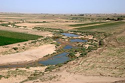
Rio Cabur
| Cabur | |
|---|---|
| O rio Cabur ao sul de Al Hasakah. | |
 | |
| Nascente | Ras al-'Ayn |
| Altitude da nascente | 350 m |
| Foz | Rio Eufrates |
| Afluentes principais |
Aweidj, Dara, Djirdjib, Jaghjagh, Radd y Zergan |
| País(es) | |
| Coordenadas | |
O rio Cabur[1] (Khabur; em latim: Abora[2], em árabe: الخابور al-khābūr, em hebraico: כבר Kebar/Chebar, em curdo: Xabûr, em siríaco: ܚܒܘܪ ḥābur/khābur, em turco: Habur), é um rio que nasce no sudeste da Turquia, fluindo por 486 km chegando até à Síria, onde se junta ao rio Eufrates. Na maior parte do ano os rios da região (Aueije, Dara, Jirjibe, Jaguejague, Rade e Zergã) estão secos.[carece de fontes]
Atualmente, o vale Cabur é uma região muito importante para a Síria, com os seus 16000 km2 de terras aráveis, cuja produção principal é o trigo. Além disso, a região nordeste do rio, é o local de maior produção de petróleo na Síria, bem como na construção de barragens nos afluentes do rio Eufrates, tornando esta área vital para o desenvolvimento de energia desta nação.[3][4]
História
[editar | editar código-fonte]Historicamente, o vale do Cabur foi um importante centro dos hurritas, que fundou muitos reinos na área, e entre os que se destacaram, foi o Reino de Mitani. Na Bíblia, afirma-se que foi em sua costa, que estabeleceram os cativos de Israel, na qual levaram o rei assírio Salmanaser V até à Mesopotâmia.[5]
Referências
- ↑ Champlin, Russell Norman (2018). «Hala». Novo dicionário bíblico Champlin: Completo, prático, exegético, indispensável. São Paulo: Hagnos
- ↑ George Rawlinson (1871). «The Five Great Monarchies of the Ancient Eastern World; Or, The History, Geography, and Antiquites of Chaldæa, Assyria, Babylon, Media, and Persia». Scribner, Welford and Company
- ↑ Hole F, Zaitchik, BF (2007). «Policies, plans, practice, and prospects: irrigation in northeastern Syria». Land Degradation & Development. 18: 133–152. doi:10.1002/ldr.772
- ↑ Burdon, DJ, Safadi, C (1963). «Ras-el-Ain: the great karstic spring of Mesopotamia. An hydrogeological study». Journal of Hydrology. 1: 58–95. doi:10.1016/0022-1694(63)90033-7
- ↑ Nishiaki, Y. (1992). «Preliminary results of the prehistoric survey in the Khabur Basin, Syria: 1990–91 seasons». Paléorient. 18: 97–102. doi:10.3406/paleo.1992.4566
Text is available under the CC BY-SA 4.0 license; additional terms may apply.
Images, videos and audio are available under their respective licenses.

