Lodões
| ||||
|---|---|---|---|---|
| Freguesia portuguesa extinta | ||||
| Localização | ||||
 Lodões |
||||
 | ||||
| Coordenadas | 41° 19′ 11″ N, 7° 04′ 56″ O | |||
| Município primitivo | Vila Flor | |||
| História | ||||
| Extinção | 28 de janeiro de 2013 | |||
| Características geográficas | ||||
| Área total | 7,83 km² | |||
| Outras informações | ||||
| Orago | S. Tiago | |||
Lodões é uma povoação portuguesa do Município de Vila Flor que foi sede da extinta Freguesia de Lodões, freguesia que tinha 7,83 km² de área e 100 habitantes (2011), e, por isso, uma densidade populacional de 12,8 hab/km².
A Freguesia de Lodões foi extinta em 2013, no âmbito de uma reforma administrativa nacional, tendo sido agregada à Freguesia de Assares, para formar uma nova freguesia denominada União das Freguesias de Assares e Lodões.[1]
População
[editar | editar código-fonte]| População da freguesia de Lodões [2] | ||||||||||||||
|---|---|---|---|---|---|---|---|---|---|---|---|---|---|---|
| 1864 | 1878 | 1890 | 1900 | 1911 | 1920 | 1930 | 1940 | 1950 | 1960 | 1970 | 1981 | 1991 | 2001 | 2011 |
| 190 | 178 | 185 | 178 | 180 | 147 | 200 | 265 | 290 | 310 | 173 | 235 | 187 | 142 | 100 |
-
 Evolução da População 1864 / 2011
 -
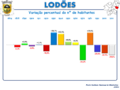 Variação da População 1864 / 2011
 -
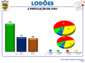 A População em 2001
 -
 A População em 2011


Património
[editar | editar código-fonte]Referências
- ↑ Diário da República, 1.ª Série, n.º 19, Lei n.º 11-A/2013 de 28 de janeiro (Reorganização administrativa do território das freguesias).
- ↑ Instituto Nacional de Estatística (Recenseamentos Gerais da População) - https://www.ine.pt/xportal/xmain?xpid=INE&xpgid=ine_publicacoes
 |  | ||
Text is available under the CC BY-SA 4.0 license; additional terms may apply.
Images, videos and audio are available under their respective licenses.
Cover photo is available under {{::mainImage.info.license.name || 'Unknown'}} license.
Cover photo is available under {{::mainImage.info.license.name || 'Unknown'}} license.
Credit:
(see original file).
