Fronteira China–Nepal
| Fronteira China–Nepal | |
|---|---|
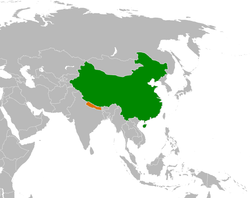
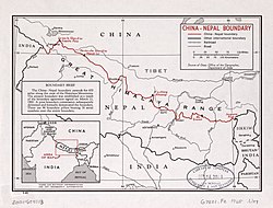
  Acima: Localização do Nepal (laranja) e da China (verde). Abaixo: Mapa da fronteira China-Nepal. | |
| Delimita: | |
| Comprimento: | 1236 km Posição: 58 |
A fronteira entre a China e o Nepal é a linha de 1236 km de extensão, ao longo da cordilheira do Himalaia, direção noroeste-sudeste, que separa o sul de Xizang (Região Autônoma do Tibete), República Popular da China, do território do Nepal. Nessa fronteira fica o mais alto pico do mundo, o Monte Everest.
A linha divisória estende entre duas fronteiras tríplices República Popular da China-Nepal-Índia, uma no oeste, na zona nepalesa de Makahali. Passa por mais 9 zonas do Nepal, até o oeste, no outro ponto tríplice com a Índia, na zona de Mechi.
Sua definição data desde a formação do primeiro reino do Nepal pelos Gurkhas, no século XVIII. É uma das mais naturais fronteiras da terra, em função da barreira do Himalaia.
A República Popular da China e o Reino do Nepal tiveram uma breve disputa de fronteira antes de 1960, [1] esta foi resolvida com a assinatura de um acordo de fronteira em 1961.

Os limites desta fronteira em particular mudaram drasticamente ao longo do tempo, especialmente quando considerados eventos relativamente recentes, como a anexação do Tibete. No entanto, alguns dos desenvolvimentos mais significativos dos tempos modernos seriam a assinatura do "Acordo para a Manutenção de Relações Amigáveis entre a República Popular da China e o Reino do Nepal" em 1956 e o "Tratado Sino-Nepalês de Paz e Amizade" em 1960, ambos os quais reconheceram formalmente o Tibete como parte da China e confirmaram os limites da China e do Nepal como são conhecidos hoje. [2][3]
Referências
- ↑
Office of the Geographer (1969). «International Boundary Study - China – Nepal Boundary» (PDF) (em inglês). Bureau of Intelligence and Research. Cópia arquivada (PDF) em 3 de maio de 2012.
The exact number of territorial disputes has never been ascertained, but as many as 20 sectors may have been involved. The most serious disputes were located at Rasu (north of Katmandu), Kimathanka in the east, Nara Pass, Tingribode near Mustang, Mount Everest, and the Nelu River. Most of these disputes were settled in favor of Nepal, although several favored China.
- ↑ Van Tronder, Gerry (2018). Sino-Indian War: Border Clash: October–November 1962. [S.l.]: Pen and Sword Military. ISBN 9781526728388
- ↑ Adhikari, Monalisa (2012). «Between the Dragon and the Elephant: Nepal's Neutrality Conundrum». Indian Journal of Asian Affairs. 25 (1/2): 85. JSTOR 41950522
Text is available under the CC BY-SA 4.0 license; additional terms may apply.
Images, videos and audio are available under their respective licenses.
