Ficheiro:Great Fire of London Map.png
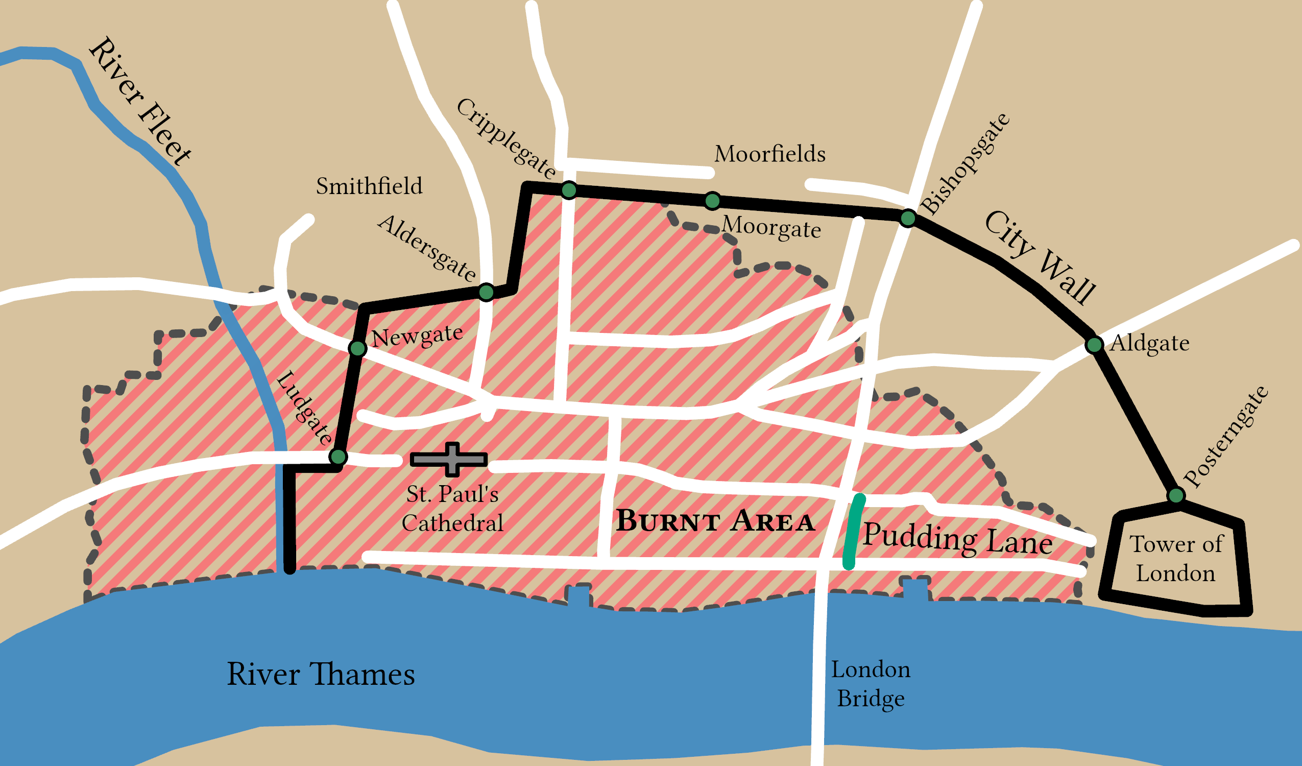
Imagem numa resolução maior (2 550 × 1 500 píxeis, tamanho: 342 kB, tipo MIME: image/png)
|
|
Esta imagem provém do Wikimedia Commons, um acervo de conteúdo livre da Wikimedia Foundation que pode ser utilizado por outros projetos.
|

|
Esta imagem de city map (ou todas as imagens neste artigo ou categoria) deveriam ser recriadas usando gráficos vectoriais, como ficheiros SVG. Isto tem várias vantagens; veja as Commons:Media for cleanup|imagens para rever para mais informações. Se já criou um ficheiro SVG desta imagem, por favor, carregue-o. Depois do novo ficheiro SVG ter sido carregado, substitua aqui esta predefinição pela predefinição ((vector version available|nome da nova imagem.svg)).
|
Descrição do ficheiro
| Descrição |
English: Spread of the Great Fire of London based on Tinniswood (2003, p. 97) and Hollar (1666). This map is a part of a remake of a mapseries made by Bunchofgrapes in 2006 to fix accessability issues. The orignal map was traced in ArcGIS Pro to produce this one and with consulation from reliable sources. |
||
| Data | |||
| Origem |
Este ficheiro foi derivado de: Great fire of london map.png: |
||
| Criador |
|
||
| Modo de aquisição | © Bunchofgrapes and Tom Fish // Creative Commons CC BY-SA 3.0 | ||
| Permissão (Reutilizar este ficheiro) |
|
||
| Georeferenciamento | |||
| Dados de arquivamento | |||
| artwork-references |
|
||
| PNG desenvolvimento | Esta carta geográfica foi criada com o ArcGIS Pro |
||
Licenciamento
- Pode:
- partilhar – copiar, distribuir e transmitir a obra
- recombinar – criar obras derivadas
- De acordo com as seguintes condições:
- atribuição – Tem de fazer a devida atribuição da autoria, fornecer uma hiperligação para a licença e indicar se foram feitas alterações. Pode fazê-lo de qualquer forma razoável, mas não de forma a sugerir que o licenciador o apoia ou subscreve o seu uso da obra.
- partilha nos termos da mesma licença – Se remisturar, transformar ou ampliar o conteúdo, tem de distribuir as suas contribuições com a mesma licença ou uma licença compatível com a original.
Histórico do ficheiro
Clique uma data e hora para ver o ficheiro tal como ele se encontrava nessa altura.
| Data e hora | Miniatura | Dimensões | Utilizador | Comentário | |
|---|---|---|---|---|---|
| atual | 11h52min de 6 de junho de 2022 | | 2 550 × 1 500 (342 kB) | Guerillero | Fix small issues |
| 15h33min de 30 de dezembro de 2021 |  | 2 125 × 1 250 (282 kB) | Guerillero | == ((int:filedesc)) == ((User:Guerillero/Template |Description= ((en|Spread of the Great Fire of London)) |Source=((Derived from|Great fire of london map.png|display=50)) |Author=((u|Bunchofgrapes)) |Date= 29 December 2021 )) == ((int:license-header)) == ((Cc-by-sa-3.0)) Category:Maps of the Great Fire of London |
Utilização local do ficheiro
A seguinte página usa este ficheiro:
Utilização global do ficheiro
As seguintes wikis usam este ficheiro:
- azb.wikipedia.org
- en.wikipedia.org
- lv.wikipedia.org
- mr.wikipedia.org
- sl.wikipedia.org
Metadados
Text is available under the CC BY-SA 4.0 license; additional terms may apply.
Images, videos and audio are available under their respective licenses.
