دوتنه:Slovakia-map.png
تر دې کچې لوړې بېلن نښې نشته.
Slovakia-map.png (۶۵۸ × ۳۳۷ پېکسل, د دوتنې کچه: ۱۱ کيلوبايټ, MIME بڼه: image/png)

|
File:Slovakia map rivers and cities 2008-11-17.svg is a vector version of this file. It should be used in place of this PNG file when not inferior.
File:Slovakia-map.png → File:Slovakia map rivers and cities 2008-11-17.svg
For more information, see Help:SVG. |
 |
لنډيز
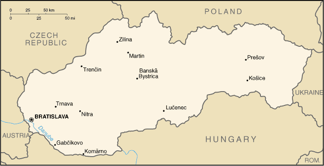
From Cia Factbook
منښتليک:
This image is in the public domain because it contains materials that originally came from the United States Central Intelligence Agency's World Factbook.
|
 |
derivative works
Derivative works of this file: Slovacchiait.png
د دوتنې پېښليک
په يوې نېټې/يوه وخت وټوکۍ چې د هماغه وخت او نېټې دوتنه چې څنگه ښکارېده هماغسې درښکاره شي.
| نېټه/وخت | بټنوک | ډډې | کارن | تبصره | |
|---|---|---|---|---|---|
| اوسنی | ۲۱:۱۶, ۱۷ سپټمبر ۲۰۰۵ | | ۶۵۸ × ۳۳۷ (۱۱ کيلوبايټ) | Gmelfi | [Category:Maps of Slovakia] From Cia Factbook |
د دوتنې کارېدنه
دا لاندينی مخ د همدې دوتنې سره تړنې لري:
د نړېوالې دوتنې کارېدنه
همدا دوتنه لاندينۍ نورې ويکي گانې کاروي:
- په dsb.wikipedia.org کارونې
- په fa.wikipedia.org کارونې
- په gl.wikipedia.org کارونې
- په lfn.wikipedia.org کارونې
- په nl.wikipedia.org کارونې
- په pt.wikipedia.org کارونې
- په sq.wikipedia.org کارونې
- په sw.wikipedia.org کارونې
Text is available under the CC BY-SA 4.0 license; additional terms may apply.
Images, videos and audio are available under their respective licenses.
Cover photo is available under {{::mainImage.info.license.name || 'Unknown'}} license.
Cover photo is available under {{::mainImage.info.license.name || 'Unknown'}} license.
Credit:
(see original file).
