For faster navigation, this Iframe is preloading the Wikiwand page for دوتنه:Czechoslovakia.png.

دوتنه:Czechoslovakia.png
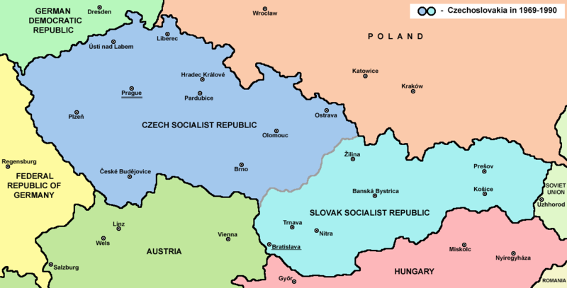
اصلي دوتنه(۱٬۱۸۸ × ۶۰۴ پېکسل, د دوتنې کچه: ۶۹ کيلوبايټ, MIME بڼه: image/png)

دا دوتنه د ويکيمېډيا کامنز لخوا خپرېږې او کېدای شي چې دا په نورو پروژو هم کارېدلې وي. د دوتنې د کارېدنې لا نور مالومات د دوتنې د څرگندنو په مخ کې لاندې ښودل شوی.

This historical map image could be re-created using vector graphics as an SVG file. This has several advantages; see Commons:Media for cleanup for more information. If an SVG form of this image is available, please upload it and afterwards replace this template with ((vector version available|new image name)).
It is recommended to name the SVG file “Czechoslovakia.svg”—then the template Vector version available (or Vva) does not need the new image name parameter.

لنډيز

څرگندونه
English: Map of Czechoslovakia in 1969-1990
سرچينه شخصي اثر
ليکوال PANONIAN
نورې بڼې Derivative works of this file:

منښتليک:

This work has been released into the public domain by its author, PANONIAN, at the انګليسي ويکيپېډيا project. This applies worldwide.

In case this is not legally possible:
PANONIAN grants anyone the right to use this work for any purpose, without any conditions, unless such conditions are required by law.

References

Main reference:

Secondary references with similar maps:

Secondary references about Geo-political situation - published sources:

  • The Times History of Europe, Times Books, London, 2002.
  • Richard Overy, The Times History of the 20th Century, Times Books, London, 2004.
  • The Times Atlas svjetske povijesti, Cankarjeva založba, Ljubljana - Zagreb, 1986.
  • Istorijski atlas, Geokarta, Beograd, 1999.
  • Školski istorijski atlas, Zavod za izdavanje udžbenika SR Srbije, Beograd, 1970.
  • Povijesni atlas, Učila - Zagreb, Zagreb, 1971.
  • Povijesni atlas za osnovnu školu, Kartografija - Tlos, Zagreb, 1975.
  • Denis Šehić - Demir Šehić, Istorijski atlas sveta, Beograd, 2007.

Secondary reference about sizable cities:

This map image could be re-created using vector graphics as an SVG file. This has several advantages; see Commons:Media for cleanup for more information. If an SVG form of this image is available, please upload it and afterwards replace this template with ((vector version available|new image name)).
It is recommended to name the SVG file “Czechoslovakia.svg”—then the template Vector version available (or Vva) does not need the new image name parameter.


Captions

Add a one-line explanation of what this file represents

Items portrayed in this file

depicts انګليسي

source of file انګليسي

media type انګليسي

image/png

checksum انګليسي

988843af23cf6b2ab48cfc10bab00f4951a2c319

determination method انګليسي: SHA-1 انګليسي

data size انګليسي

۷۱٬۰۵۸ بايټ

height انګليسي

۶۰۴ پېکسل

width انګليسي

۱٬۱۸۸ پېکسل

د دوتنې پېښليک

په يوې نېټې/يوه وخت وټوکۍ چې د هماغه وخت او نېټې دوتنه چې څنگه ښکارېده هماغسې درښکاره شي.

نېټه/وختبټنوکډډېکارنتبصره
اوسنی۱۴:۴۵, ۱۲ جولای ۲۰۲۲د ۱۴:۴۵, ۱۲ جولای ۲۰۲۲ پورې د بټنوک بڼه۱٬۱۸۸ × ۶۰۴ (۶۹ کيلوبايټ)Sebastian WallrothCROPPED
۱۷:۳۸, ۱۲ فبروري ۲۰۱۷د ۱۷:۳۸, ۱۲ فبروري ۲۰۱۷ پورې د بټنوک بڼه۱٬۲۲۱ × ۶۵۲ (۶۹ کيلوبايټ)WikiEditor2004Reverted to version as of 11:00, 24 April 2011 (UTC) - why you uploading polish version over english one? upload polish version under different filename
۱۵:۱۸, ۹ فبروري ۲۰۱۷د ۱۵:۱۸, ۹ فبروري ۲۰۱۷ پورې د بټنوک بڼه۱٬۲۲۱ × ۶۵۲ (۵۷ کيلوبايټ)KelvinReverted to version as of 15:13, 9 February 2017 (UTC)
۱۵:۱۷, ۹ فبروري ۲۰۱۷د ۱۵:۱۷, ۹ فبروري ۲۰۱۷ پورې د بټنوک بڼه۱٬۲۲۱ × ۶۵۲ (۶۹ کيلوبايټ)KelvinReverted to version as of 11:00, 24 April 2011 (UTC)
۱۵:۱۳, ۹ فبروري ۲۰۱۷د ۱۵:۱۳, ۹ فبروري ۲۰۱۷ پورې د بټنوک بڼه۱٬۲۲۱ × ۶۵۲ (۵۷ کيلوبايټ)KelvinPolish names of countries /Polskie określenia krajów
۱۱:۰۰, ۲۴ اپرېل ۲۰۱۱د ۱۱:۰۰, ۲۴ اپرېل ۲۰۱۱ پورې د بټنوک بڼه۱٬۲۲۱ × ۶۵۲ (۶۹ کيلوبايټ)WikiEditor2004correction
۱۰:۲۷, ۲۳ اپرېل ۲۰۱۱د ۱۰:۲۷, ۲۳ اپرېل ۲۰۱۱ پورې د بټنوک بڼه۱٬۲۲۱ × ۶۵۲ (۶۹ کيلوبايټ)WikiEditor2004improved version
۲۳:۳۱, ۱۰ ډيسمبر ۲۰۰۶د ۲۳:۳۱, ۱۰ ډيسمبر ۲۰۰۶ پورې د بټنوک بڼه۱٬۲۰۰ × ۶۲۴ (۱۹ کيلوبايټ)Severino666~commonswikiMap of Czechoslovakia (self made) Category:Maps of Czechoslovakia Category:Maps of Czech history Category:Maps of the history of Slovakia Category:Maps of the history of Central Europe ((PD))

د دوتنې کارېدنه

دا لاندينی مخ د همدې دوتنې سره تړنې لري:

د نړېوالې دوتنې کارېدنه

همدا دوتنه لاندينۍ نورې ويکي گانې کاروي:

د دې دوتنې نورې نړېوالې کارېدنې کتل.

مېټاډاټا

{{bottomLinkPreText}} {{bottomLinkText}}
دوتنه:Czechoslovakia.png
Listen to this article

This browser is not supported by Wikiwand :(
Wikiwand requires a browser with modern capabilities in order to provide you with the best reading experience.
Please download and use one of the following browsers:

This article was just edited, click to reload
This article has been deleted on Wikipedia (Why?)

Back to homepage

Please click Add in the dialog above
Please click Allow in the top-left corner,
then click Install Now in the dialog
Please click Open in the download dialog,
then click Install
Please click the "Downloads" icon in the Safari toolbar, open the first download in the list,
then click Install
{{::$root.activation.text}}

Install Wikiwand

Install on Chrome Install on Firefox
Don't forget to rate us

Tell your friends about Wikiwand!

Gmail Facebook Twitter Link

Enjoying Wikiwand?

Tell your friends and spread the love:
Share on Gmail Share on Facebook Share on Twitter Share on Buffer

Our magic isn't perfect

You can help our automatic cover photo selection by reporting an unsuitable photo.

This photo is visually disturbing This photo is not a good choice

Thank you for helping!


Your input will affect cover photo selection, along with input from other users.

X

Get ready for Wikiwand 2.0 🎉! the new version arrives on September 1st! Don't want to wait?