For faster navigation, this Iframe is preloading the Wikiwand page for فائل:Maurya Empire, c.250 BCE 2.png.

فائل:Maurya Empire, c.250 BCE 2.png

اصل فائل(۱,۲۰۰ × ۱,۱۲۱ پکسلز, فائل حجم: ۲.۲۶ میگابائٹ, MIME type: image/png)

ایہ فائل Wikimedia Commons توں اے تے دوجیاں ویونتاں تے وی ورتی جاسکدی اے۔ گل بات اس دے فائل گل بات صفحہ تے تھلے دتی گئی۔

خلاصہ

تفصیل
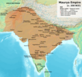
English: Note: This was the standard "textbook" map of the Maurya Empire. Historians are now arguing that the Maurya Empire did not include large parts of India, which were controlled by autonomous tribes. For such a map, see File:Maurya Empire, c.250 BCE.png.
Alternative map of Maurya Empire

Boundaries are based on Charles Joppen Historical Atlas of India (1907), see File:India_in_250_B._C.jpg.

Other Sources:

Other sources:

  • Grainger, John D. (1990, 2014). Seleukos Nikator: Constructing a Hellenistic Kingdom. Routledge.
  • Keay, John (2000). India, a History. New York: Harper Collins Publishers.
  • Kulke, H.; Rothermund, D. (2004). A History of India, 4th, Routledge.
  • Puri, Baji Nath (1996). Buddhism in Central Asia. Delhi: Motilal Banarsidass.
  • Raychaudhuri, H. C.; Mukherjee, B. N. (1996). Political History of Ancient India: From the Accession of Parikshit to the Extinction of the Gupta Dynasty. Oxford University Press.
  • Stein, Burton (1998). A History of India (1st ed.), Oxford: Wiley-Blackwell.

Notes:

  • Sri Lanka and the southernmost parts of India (modern Tamil Nadu and Kerala) remained independent, despite the diplomacy and cultural influence of their larger neighbor to the north (Schwartzberg 1992, p. 18; Kulke & Rothermund 2004, p. 68).
  • The account of Strabo indicates that the western-most territory of the empire extended from the southeastern Hindu Kush, through the region of Kandahar, to coastal Baluchistan south of that (Raychaudhuri & Mukherjee 1996, p. 594).
  • The claim that Aria/Herat was one of the provinces (alongside Arachosia, Gedrosia, and Paropamisadae) ceded by Seleucus to Chandragupta Maurya is often repeated, but Aria (modern Herat) "has been wrongly included in the list of ceded satrapies by some scholars [...] on the basis of wrong assessments of the passage of Strabo [...] and a statement by Pliny." (Raychaudhuri & Mukherjee 1996, p. 594). Seleucus "must [...] have held Aria", and furthermore, his "son Antiochos was active there fifteen years later." (Grainger 2014, p. 109).
  • "The region of Aria is definitely known to have been Seleucid under Seleucus I and Antiochus I as it definitely was after Antiochus III's great campaign in the east against the Parthians and Bactrians. [...] There is no evidence whatever that it did not remain Seleucid, like Drangiana, with which it is linked by easy routes." -Susan M. Sherwin-White and Amélie Kuhrt (1993) From Samarkhand to Sardis: A New Approach to the Seleucid Empire, University of California Press, pp.79-80.
  • It is recorded that Drangiana province continued to be in the Seleucids' hands, as per [1].
  • "Desert of Gedrosia [...] was left an unclaimed wilderness." —Kosmin, Paul J. (2014), The Land of the Elephant Kings Space, Territory, and Ideology in the Seleucid Empire, Harvard University Press, p.16
  • Schwartzberg (p. 18) speculates about the Buddhist culture and Kharosthi inscriptions/manuscripts found in Khotan, but these texts from Khotan, Turfan, and Tajikstan have all been shown to be later than the 1st century BCE (Puri, p. 185).
تریخ
سروت آپݨا کم
لکھاری Avantiputra7

لائسنس –

میں، اس کم دے کاپیرائٹ دا مالک، اس کم نوں اس لائسنس دے مطابق چھاپدا واں:
w:en:Creative Commons
کس دے ناں اکو جہا شئیر کرو۔
ایس فائل نوں کریٹو کامنز Attribution 2.5 پولینڈ لائسنس دتا گیا.
تہانوں کھلھ اے:
  • حصہ کرنا – کاپی، ونڈنا تے کم بھیجنا
  • فیر رلانا – کم نوں فٹ کرنا
تھلے دتیاں شرطاں نال:
  • کس دے ناں – تسیں لازمی ایس کم دے بناں والے بارے دسو جنج اونے آکھیا اے یا جنج لسنس چ آکھیا گیا ہے۔
  • اکو جہا شئیر کرو۔ – اگر تسیں بدلدے یا ایس کم تے بناندے تے بنن والے کم نوں اینج دے لسنس نال ای ونڈو گے۔

Captions

Add a one-line explanation of what this file represents

Items portrayed in this file

چترن

copyrighted English

۳ جولائی 2014

media type English

image/png

فائل دی تریخ

فائل نو اس ویلے دی حالت وچ ویکھن واسطے تاریخ/ویلے تے کلک کرو۔

(سبھ توں نواں | سبھ توں پراݨا) ویکھو (زیادہ نواں ۱۰ | ) (۱۰ | ۲۰ | ۵۰ | ۱۰۰ | ۲۵۰ | ۵۰۰)
تریخ تے ویلہنکی مورتپاسےورتن والاتیپّݨی کرو
موجودہ۱۳:۲۷, ۲۷ جون ۲۰۲۴۱۳:۲۷, ۲۷ جون ۲۰۲۴ ویلے دے ورژن ساتھ انگوٹھاکار روپ۱,۲۰۰ × ۱,۱۲۱ (۲.۲۶ میگابائٹ)Avantiputra7Reverted to version as of 11:01, 30 April 2024 (UTC) - vandalism
۱۳:۵۲, ۱۹ جون ۲۰۲۴۱۳:۵۲, ۱۹ جون ۲۰۲۴ ویلے دے ورژن ساتھ انگوٹھاکار روپ۱,۲۰۰ × ۱,۱۲۱ (۲.۱۸ میگابائٹ)Chakravartin1929Reverted to version as of 07:37, 14 April 2024 (UTC) This version is not even based on joppen's map. It's westernmost lands clearly dont match with that of joppen's map hence reverting to this.
۱۶:۰۱, ۳۰ اپریل ۲۰۲۴۱۶:۰۱, ۳۰ اپریل ۲۰۲۴ ویلے دے ورژن ساتھ انگوٹھاکار روپ۱,۲۰۰ × ۱,۱۲۱ (۲.۲۶ میگابائٹ)Avantiputra7western borders: see talk page
۰۹:۳۷, ۱۶ اپریل ۲۰۲۴۰۹:۳۷, ۱۶ اپریل ۲۰۲۴ ویلے دے ورژن ساتھ انگوٹھاکار روپ۱,۲۰۰ × ۱,۱۲۱ (۲.۲۶ میگابائٹ)Avantiputra7Reverted to version as of 11:12, 5 April 2024 (UTC) - vandalism
۱۲:۳۷, ۱۴ اپریل ۲۰۲۴۱۲:۳۷, ۱۴ اپریل ۲۰۲۴ ویلے دے ورژن ساتھ انگوٹھاکار روپ۱,۲۰۰ × ۱,۱۲۱ (۲.۱۸ میگابائٹ)Layman7676Reverted to version as of 11:12, 4 April 2024 (UTC) The map you are publishing isn't based on wha vincient Arthur really said.
۱۶:۱۲, ۵ اپریل ۲۰۲۴۱۶:۱۲, ۵ اپریل ۲۰۲۴ ویلے دے ورژن ساتھ انگوٹھاکار روپ۱,۲۰۰ × ۱,۱۲۱ (۲.۲۶ میگابائٹ)Avantiputra7Reverted to version as of 08:27, 3 April 2024 (UTC) - vandalism
۱۶:۱۲, ۴ اپریل ۲۰۲۴۱۶:۱۲, ۴ اپریل ۲۰۲۴ ویلے دے ورژن ساتھ انگوٹھاکار روپ۱,۲۰۰ × ۱,۱۲۱ (۲.۱۸ میگابائٹ)Chakravartin1929Reverted to version as of 05:41, 26 March 2024 (UTC) This is the true map. It depicts The mauryan map accurately.
۱۳:۲۷, ۳ اپریل ۲۰۲۴۱۳:۲۷, ۳ اپریل ۲۰۲۴ ویلے دے ورژن ساتھ انگوٹھاکار روپ۱,۲۰۰ × ۱,۱۲۱ (۲.۲۶ میگابائٹ)Avantiputra7Reverted to version as of 11:06, 3 March 2024 (UTC)
۱۰:۴۱, ۲۶ مارچ ۲۰۲۴۱۰:۴۱, ۲۶ مارچ ۲۰۲۴ ویلے دے ورژن ساتھ انگوٹھاکار روپ۱,۲۰۰ × ۱,۱۲۱ (۲.۱۸ میگابائٹ)Chakravartin1929Reverted to version as of 09:06, 3 March 2024 (UTC)
۱۶:۰۶, ۳ مارچ ۲۰۲۴۱۶:۰۶, ۳ مارچ ۲۰۲۴ ویلے دے ورژن ساتھ انگوٹھاکار روپ۱,۲۰۰ × ۱,۱۲۱ (۲.۲۶ میگابائٹ)Avantiputra7Reverted to version as of 11:10, 29 January 2024 (UTC)
(سبھ توں نواں | سبھ توں پراݨا) ویکھو (زیادہ نواں ۱۰ | ) (۱۰ | ۲۰ | ۵۰ | ۱۰۰ | ۲۵۰ | ۵۰۰)

فائل دی ورتوں

تھلے دتے گئے 1 صفحے اس فائل نال جُڑدے نیں

فائل ویاپک ورتوں

ایہہ دوجے وکیاں ایس فائل نوں ورتدے نیں –

ایس فائل دا ویکھو ہور جگت ورتن .

میٹا ڈیٹا

{{bottomLinkPreText}} {{bottomLinkText}}
فائل:Maurya Empire, c.250 BCE 2.png
Listen to this article

This browser is not supported by Wikiwand :(
Wikiwand requires a browser with modern capabilities in order to provide you with the best reading experience.
Please download and use one of the following browsers:

This article was just edited, click to reload
This article has been deleted on Wikipedia (Why?)

Back to homepage

Please click Add in the dialog above
Please click Allow in the top-left corner,
then click Install Now in the dialog
Please click Open in the download dialog,
then click Install
Please click the "Downloads" icon in the Safari toolbar, open the first download in the list,
then click Install
{{::$root.activation.text}}

Install Wikiwand

Install on Chrome Install on Firefox
Don't forget to rate us

Tell your friends about Wikiwand!

Gmail Facebook Twitter Link

Enjoying Wikiwand?

Tell your friends and spread the love:
Share on Gmail Share on Facebook Share on Twitter Share on Buffer

Our magic isn't perfect

You can help our automatic cover photo selection by reporting an unsuitable photo.

This photo is visually disturbing This photo is not a good choice

Thank you for helping!


Your input will affect cover photo selection, along with input from other users.

X

Get ready for Wikiwand 2.0 🎉! the new version arrives on September 1st! Don't want to wait?