For faster navigation, this Iframe is preloading the Wikiwand page for فائل:Island of Ireland location map Kildare.svg.

فائل:Island of Ireland location map Kildare.svg
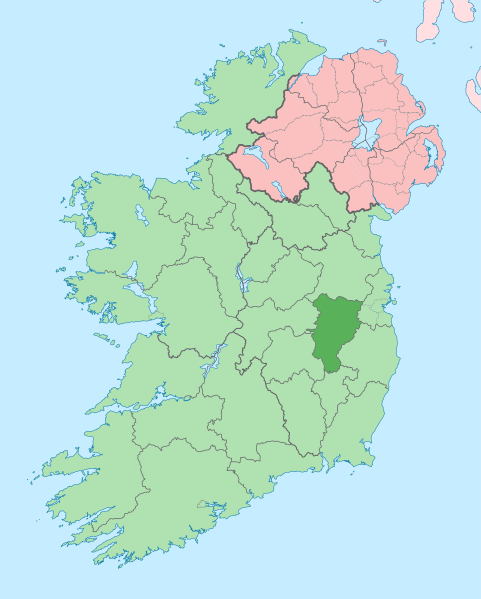
اصل فائل(ایس وی جی فائل، پکسل:۱,۴۵۰ × ۱,۸۰۷، فائل سائز: ۶۴۲ کلوبائٹ)

ایہ فائل Wikimedia Commons توں اے تے دوجیاں ویونتاں تے وی ورتی جاسکدی اے۔ گل بات اس دے فائل گل بات صفحہ تے تھلے دتی گئی۔

تفصیل
English: The island of Ireland, showing international border between Ireland and Northern Ireland, traditional provinces, traditional counties, and local authority areas in Ireland and Northern Ireland.
تریخ (UTC)
سروت
لکھاری


This is a retouched picture, which means that it has been digitally altered from its original version. Modifications: Coloured in regions with county of article highlighted. The original can be viewed here: Island of Ireland location map.svg. Modifications made by Mabuska.

میں، اس کم دے کاپیرائٹ دا مالک، اس کم نوں اس لائسنس دے مطابق چھاپدا واں:
w:en:Creative Commons
کس دے ناں اکو جہا شئیر کرو۔
ایس فائل نوں کریٹو کامنز Attribution 2.5 پولینڈ لائسنس دتا گیا.
تہانوں کھلھ اے:
  • حصہ کرنا – کاپی، ونڈنا تے کم بھیجنا
  • فیر رلانا – کم نوں فٹ کرنا
تھلے دتیاں شرطاں نال:
  • کس دے ناں – تسیں لازمی ایس کم دے بناں والے بارے دسو جنج اونے آکھیا اے یا جنج لسنس چ آکھیا گیا ہے۔
  • اکو جہا شئیر کرو۔ – اگر تسیں بدلدے یا ایس کم تے بناندے تے بنن والے کم نوں اینج دے لسنس نال ای ونڈو گے۔

پہلا اپلوڈ دا ریکارڈ

This image is a derivative work of the following images:

  • File:Island_of_Ireland_location_map.svg licensed with Cc-by-sa-3.0
    • 2010-03-06T20:43:33Z Rannpháirtí anaithnid 1450x1807 (679207 Bytes) Fix incorrectly coloured isands.
    • 2010-03-03T22:19:29Z Rannpháirtí anaithnid 1450x1807 (679744 Bytes) ((Information |Description=((de|Positionskarte von [[:de:Irland|Irland]])) Quadratische Plattkarte, N-S-Streckung 170 %. Geographische Begrenzung der Karte: * N: 55.6° N * S: 51.2° N * W: 11.0° W * O: 5.0° W ((en|Location

Uploaded with derivativeFX

Captions

Add a one-line explanation of what this file represents
map of Ireland with County Kildare highlighted in dark green

Items portrayed in this file

چترن

copyrighted English

۱۹ جولائی 2010

media type English

image/svg+xml

فائل دی تریخ

فائل نو اس ویلے دی حالت وچ ویکھن واسطے تاریخ/ویلے تے کلک کرو۔

تریخ تے ویلہنکی مورتپاسےورتن والاتیپّݨی کرو
موجودہ۱۴:۱۲, ۳ جولائی ۲۰۲۰۱۴:۱۲, ۳ جولائی ۲۰۲۰ ویلے دے ورژن ساتھ انگوٹھاکار روپ۱,۴۵۰ × ۱,۸۰۷ (۶۴۲ کلوبائٹ)ChipmunkdavisPer the Local Government Reform Act 2014, joining both Tipperarys and both Waterfords (and removing Limerick City code). Colouring in islands, cleaning up and grouping code to remove stray objects and show Galway and Lough Ree.
۰۵:۴۸, ۱۹ جولائی ۲۰۱۰۰۵:۴۸, ۱۹ جولائی ۲۰۱۰ ویلے دے ورژن ساتھ انگوٹھاکار روپ۱,۴۵۰ × ۱,۸۰۷ (۸۱۵ کلوبائٹ)Mabuska((Information |Description=((en|The island of Ireland, showing international border between Northern Ireland and Republic of Ireland, traditional provinces, traditional counties, and local authority areas in the Republic of Ireland and Northern Ireland.))

فائل دی ورتوں

تھلے دتے گئے 1 صفحے اس فائل نال جُڑدے نیں

فائل ویاپک ورتوں

میٹا ڈیٹا

{{bottomLinkPreText}} {{bottomLinkText}}
فائل:Island of Ireland location map Kildare.svg
Listen to this article

This browser is not supported by Wikiwand :(
Wikiwand requires a browser with modern capabilities in order to provide you with the best reading experience.
Please download and use one of the following browsers:

This article was just edited, click to reload
This article has been deleted on Wikipedia (Why?)

Back to homepage

Please click Add in the dialog above
Please click Allow in the top-left corner,
then click Install Now in the dialog
Please click Open in the download dialog,
then click Install
Please click the "Downloads" icon in the Safari toolbar, open the first download in the list,
then click Install
{{::$root.activation.text}}

Install Wikiwand

Install on Chrome Install on Firefox
Don't forget to rate us

Tell your friends about Wikiwand!

Gmail Facebook Twitter Link

Enjoying Wikiwand?

Tell your friends and spread the love:
Share on Gmail Share on Facebook Share on Twitter Share on Buffer

Our magic isn't perfect

You can help our automatic cover photo selection by reporting an unsuitable photo.

This photo is visually disturbing This photo is not a good choice

Thank you for helping!


Your input will affect cover photo selection, along with input from other users.

X

Get ready for Wikiwand 2.0 🎉! the new version arrives on September 1st! Don't want to wait?