Torie-Chol

| |
| Położenie | |
| Państwo | |
|---|---|
| Wysokość lustra |
1148,8 m n.p.m. |
| Morfometria | |
| Powierzchnia |
42 km² |
| Wymiary • max długość • max szerokość |
|
Położenie na mapie Tuwy 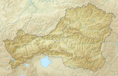 | |
Położenie na mapie Rosji 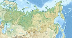 | |
Torie-Chol (Tore-Chol, Tere-Chol, Tierie-Chol) (ros. Торе-Холь, Тере-Холь; mong. Дөрөө нуур, Döröö nuur) – słodkowodne jezioro na granicy Rosji (południowa Tuwa) i północnej Mongolii, w Kotlinie Uwskiej.
Powierzchnia około 42 km² (rosyjska część 35 km², a mongolska 7 km²). Długość 16 km, szerokość 4 km. Leży na wysokości 1148,8 m n.p.m. Brzegi jeziora są niskie i piaszczyste; występują liczne piaszczyste diuny (głównie w części południowej).
Zobacz też
[edytuj | edytuj kod]Text is available under the CC BY-SA 4.0 license; additional terms may apply.
Images, videos and audio are available under their respective licenses.
Cover photo is available under {{::mainImage.info.license.name || 'Unknown'}} license.
Cover photo is available under {{::mainImage.info.license.name || 'Unknown'}} license.
Credit:
(see original file).
