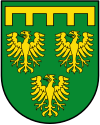
Rommerskirchen
| gmina | |||||
 Kościół św. Piotra w Rommerskirchen | |||||
| |||||
| Państwo | |||||
|---|---|---|---|---|---|
| Kraj związkowy | |||||
| Rejencja | |||||
| Powiat | |||||
| Powierzchnia |
60,08 km² | ||||
| Wysokość |
70 m n.p.m. | ||||
| Populacja (31 grudnia 2010) • liczba ludności |
| ||||
| • gęstość |
217 os./km² | ||||
| Numer kierunkowy |
02164-02181-02183 | ||||
| Kod pocztowy |
41569 | ||||
| Tablice rejestracyjne |
NE, GV | ||||
Adres urzędu: Bahnstraße 5141569 Rommerskirchen | |||||
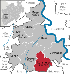
Położenie na mapie powiatu
| |||||
| 51°02′N 6°41′E/51,033333 6,683333 | |||||
| Strona internetowa | |||||

Rommerskirchen – gmina w Niemczech, w kraju związkowym Nadrenia Północna-Westfalia, w rejencji Düsseldorf, w powiecie Rhein-Kreis Neuss. W 2010 roku liczyła 13 011[1] mieszkańców.
Podział administracyjny
[edytuj | edytuj kod]W skład gminy wchodzą następujące części miejscowości:
|
|
Sąsiadujące miejscowości z Rommerskirchen:
| Grevenbroich | Grevenbroich | Dormagen |
| Grevenbroich | 
|
Dormagen |
| Bedburg | Pulheim Bergheim |
Pulheim[2] |
Transport
[edytuj | edytuj kod]
Gmina leży przy linii kolejowej Kolonia – Grevenbroich – Mönchengladbach.
Kultura i sztuka
[edytuj | edytuj kod]Muzea
[edytuj | edytuj kod]- Muzeum Rolnictwa w dzielnicy Sinsteden
- Muzeum Kolejnictwa w dzielnicy Oekoven
Religia
[edytuj | edytuj kod]- kościół św. Piotra (St. Peter)
- kościół św. Marcina (St.-Martinus-Kirche) w dzielnicy Nettesheim
- kaplica św. Lamberta (St.-Lambertus-Kapelle) w dzielnicy Ramrath
- romańska bazylika (St. Briktius) w dzielnicy Oekoven
- kościół św. Antoniego (St. Antonius) w dzielnicy Evinghoven
- kościół św. Stefana (St. Stephanus) w dzielnicy Hoeningen
Współpraca
[edytuj | edytuj kod]Miejscowości partnerskie[3]:
Przypisy
[edytuj | edytuj kod]- ↑ IT.NRW Amtliche Bevölkerungszahlen. it.nrw.de. [zarchiwizowane z tego adresu (2011-07-29)]. (niem.). (urzędowe liczby mieszkańców dla Nadrenii Północnej-Westfalii).
- ↑ Mapa Rommerskirchen z Maps.Google.pl, 2 lutego 2010.
- ↑ Współpraca.
Text is available under the CC BY-SA 4.0 license; additional terms may apply.
Images, videos and audio are available under their respective licenses.


