Ralik Chain
| Państwo | |
|---|---|
| Akwen | |
Mapa
| |
Położenie na mapie Oceanu Spokojnego  | |
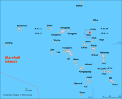
Ralik Chain[1] (pol. „zachód słońca, zachód”[2]) – jeden z dwóch łańcuchów wysp i atoli państwa wyspiarskiego Wysp Marshalla na Oceanie Spokojnym; drugim łańcuchem jest Ratak Chain[1] (pol. „wschód słońca, wschód”[2]).
Położony na zachodzie Wysp Marshall łańcuch obejmuje trzy wyspy: Jabwot, Kili i Lib oraz 15 atoli[3][4]:
| Numer | Zdjęcie | Nazwa atolu[1] |
Liczba wysepek | Powierzchnia lądu km² |
Powierzchnia laguny km² |
Opis |
|---|---|---|---|---|---|---|
| 1 | 
|
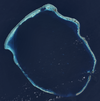
Ailinginae | 25[5] | 2,80[5] | 105,96[5] | Niezamieszkany[3] |
| 2 | 
|
Ailinglapalap | 52[6] | 14,69[6] | 750,29[6] | |
| 3 | 
|
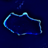
Bikini | 36[7] | 6,01[7] | 594,14[7] | Miejsce prowadzenia przez Stany Zjednoczone prób z bronią jądrową[3]. W 2010 roku atol Bikini – miejsce prób jądrowych został wpisany na listę światowego dziedzictwa UNESCO[8]. |
| 4 | 
|
Ebon | 22[9] | 5,75[9] | 103,83[9] | |
| 5 | 
|
Enewetak | 40[10] | 5,85[10] | 1004,89[10] | Miejsce prowadzenia przez Stany Zjednoczone prób z bronią jądrową[3]. Pierwsza w historii detonacja bomby wodorowej – bomby nazwanej Ivy Mike – zniszczyła doszczętnie wysepkę Elugelab[11]. |
| 6 | 
|
Jaluit | 84[12] | 11,34[12] | 689,74[12] | |
| 7 | 
|
Kwajalein | 93[13] | 16,39[13] | 2173,78[13] | Największy pod względem zajmowanej powierzchni atol na świecie[3]. |
| 8 | 
|
Lae | 17[14] | 1,45[14] | 17,66[14] | |
| 9 | 
|
Namorik | 2[15] | 2,77[15] | 8,42[15] | |
| 10 | 
|
Namu | 51[16] | 6,27[16] | 397,64[16] | |
| 11 | 
|
Rongelap | 61[17] | 7,95[17] | 1004,32[17] | |
| 12 | 
|
Rongerik | 17[18] | 1,68[18] | 143,95[18] | Niezamieszkany[3] |
| 13 | 
|
Ujae | 14[19] | 1,86[19] | 185,94[19] | |
| 14 | 
|
Ujelang | 32[20] | 1,74[20] | 65,97[20] | |
| 15 | 
|
Wotho | 13[21] | 4,33[21] | 94,92[21] |
Historia
[edytuj | edytuj kod]Niewiele wiadomo na temat historii Wysp Marshalla przed przybyciem Europejczyków[22]. Hiszpanie odwiedzali wyspy wielokrotnie w latach 1522–1568[22]. W 1528 roku hiszpański żeglarz Álvaro de Saavedra Cerón (zm. 1529) odkrył atole Ailinginae i Rongelap, a w 1529 roku Enewetak i Ujelang[23]. W 1543 roku hiszpański podróżnik Ruy López de Villalobos (1500–1544) odkrył atole Kwajalein, Lea, Ujale i Wotho[23]. W 1568 roku hiszpański żeglarz Álvaro de Mendaña de Neyra (1541–1595) odkrył atol Namu[24].
W 1767 roku angielski oficer brytyjskiej marynarki Royal Navy Samuel Wallis (1728–1795) odkrył atol Rongerik[23].
W 1817 roku rosyjski podróżnik i odkrywca Otto von Kotzebue (1788–1846) dotarł do archipelagów Ratak i Ralik na pokładzie statku Rurik[22]. W 1825 roku Kotzebue odkrył atol Bikini[23].
Po II wojnie światowej Stany Zjednoczone przeprowadziły serie prób z bronią jądrową na atolach Bikini (Operacja Crossroads, 1946) i Enewetak (Operacja Ivy, 1952)[11].
Przypisy
[edytuj | edytuj kod]- ↑ a b c Nazewnictwo Geograficzne Świata. Zeszyt 1. Komisja Standaryzacji Nazw Geograficznych, 2004, s. 143. ISBN 83-239-7552-3. (pol.).
- ↑ a b Anono Lieom Loeak, Veronica C. Kiluwe, Linda Crowl: Life in the Republic of the Marshall Islands. University of South Pacific Centre Majuro and Institute of Pacific Studies Univeristy of the South Pacific, s. 241. ISBN 978-982-02-0364-8. [dostęp 2016-07-30].
- ↑ a b c d e f Earl R. Hinz, Jim Howard: Landfalls of Paradise: Cruising Guide to the Pacific Islands. University of Hawaii Press, 2006, s. 292. ISBN 978-0-8248-3037-3. [dostęp 2016-07-30].
- ↑ Moshe Rapaport: The Pacific Islands: Environment & Society. Bess Press, 1999, s. 421-426. ISBN 978-1-57306-042-4. [dostęp 2016-07-30].
- ↑ a b c Digital Micronesia-An Electronic Library & Archive is: Marshall Islands Atoll Information Ailinginae Atoll. [dostęp 2016-07-31]. (ang.).
- ↑ a b c Digital Micronesia-An Electronic Library & Archive is: Marshall Islands Atoll Information Ailinglaplap Atoll. [dostęp 2016-07-31]. (ang.).
- ↑ a b c Digital Micronesia-An Electronic Library & Archive is: Marshall Islands Atoll Information Bikini. [dostęp 2016-07-31]. (ang.).
- ↑ UNESCO: Bikini Atoll Nuclear Test Site. [dostęp 2016-08-01]. (ang.).
- ↑ a b c Digital Micronesia-An Electronic Library & Archive is: Marshall Islands Atoll Information Ebon Atoll. [dostęp 2016-07-31]. (ang.).
- ↑ a b c Digital Micronesia-An Electronic Library & Archive is: Marshall Islands Atoll Information Enewetak Atoll. [dostęp 2016-07-31]. (ang.).
- ↑ a b Peter O. K. Krehl: History of Shock Waves, Explosions and Impact: A Chronological and Biographical Reference. Springer Science & Business Media, 2008, s. 593. ISBN 978-3-540-30421-0. [dostęp 2016-07-31]. (ang.).
- ↑ a b c Digital Micronesia-An Electronic Library & Archive is: Marshall Islands Atoll Information Jaluit Atoll. [dostęp 2016-07-31]. (ang.).
- ↑ a b c Digital Micronesia-An Electronic Library & Archive is: Marshall Islands Atoll Information Kwajalein Atoll. [dostęp 2016-07-31]. (ang.).
- ↑ a b c Digital Micronesia-An Electronic Library & Archive is: Marshall Islands Atoll Information Lae Atoll. [dostęp 2016-07-31]. (ang.).
- ↑ a b c Digital Micronesia-An Electronic Library & Archive is: Marshall Islands Atoll Information Namorik Atoll. [dostęp 2016-07-31]. (ang.).
- ↑ a b c Digital Micronesia-An Electronic Library & Archive is: Marshall Islands Atoll Information Namu Atoll. [dostęp 2016-07-31]. (ang.).
- ↑ a b c Digital Micronesia-An Electronic Library & Archive is: Marshall Islands Atoll Information Ronglap Atoll. [dostęp 2016-07-31]. (ang.).
- ↑ a b c Digital Micronesia-An Electronic Library & Archive is: Marshall Islands Atoll Information Rongerik Atoll. [dostęp 2016-07-31]. (ang.).
- ↑ a b c Digital Micronesia-An Electronic Library & Archive is: Marshall Islands Atoll Information Ujae Atoll. [dostęp 2016-07-31]. (ang.).
- ↑ a b c Digital Micronesia-An Electronic Library & Archive is: Marshall Islands Atoll Information Ujelang Atoll. [dostęp 2016-07-31]. (ang.).
- ↑ a b c Digital Micronesia-An Electronic Library & Archive is: Marshall Islands Atoll Information Wotho Atoll. [dostęp 2016-07-31]. (ang.).
- ↑ a b c Anono Lieom Loeak, Veronica C. Kiluwe, Linda Crowl: Life in the Republic of the Marshall Islands. University of South Pacific Centre Majuro and Institute of Pacific Studies Univeristy of the South Pacific, s. 192. ISBN 978-982-02-0364-8. [dostęp 2016-07-30].
- ↑ a b c d Max Quanchi, John Robson: Historical Dictionary of the Discovery and Exploration of the Pacific Islands. Lanham, Maryland; Toronto; Oxford: The Scarecrow Press, Inc., 2016-08-01, s. XX. ISBN 0-8108-5395-7. (ang.).
- ↑ Max Quanchi, John Robson: Historical Dictionary of the Discovery and Exploration of the Pacific Islands. Lanham, Maryland; Toronto; Oxford: The Scarecrow Press, Inc., 2016-08-01, s. XIX. ISBN 0-8108-5395-7. (ang.).
Text is available under the CC BY-SA 4.0 license; additional terms may apply.
Images, videos and audio are available under their respective licenses.
