Landkreis Elbe-Elster
| powiat | |||||

| |||||
| |||||
| Państwo | |||||
|---|---|---|---|---|---|
| Kraj związkowy | |||||
| Siedziba | |||||
| Kod statystyczny |
12 0 62 | ||||
| Starosta |
Christian Jaschinski (CDU) | ||||
| Powierzchnia |
1899,18 km² | ||||
| Populacja (31 grudnia 2020) • liczba ludności |
| ||||
| • gęstość |
53 os./km² | ||||
| Tablice rejestracyjne |
EE, FI, LIB | ||||
Adres urzędu: Ludwig-Jahn-Straße 204916 Herzberg (Elster) | |||||
| Szczegółowy podział administracyjny | |||||
| Liczba gmin |
33 | ||||
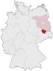
Położenie na mapie Niemiec
| |||||
Położenie na mapie Brandenburgii
| |||||
| Strona internetowa | |||||
Landkreis Elbe-Elster – powiat w niemieckim kraju związkowym Brandenburgia. Stolicą powiatu jest miasto Herzberg (Elster), natomiast największe miasto to Finsterwalde. Nazwa powiatu pochodzi od głównych rzek regionu, Łaby (niem. Elbe) i Czarnej Elstery (niem. Schwarze Elster).
Historia
[edytuj | edytuj kod]Wschodnia część powiatu obejmuje tereny historycznych Dolnych Łużyc. Powiat w obecnej formie powstał w wyniku reformy administracyjnej w 1993 roku.
Podział administracyjny
[edytuj | edytuj kod]W skład powiatu wchodzi:
- jedenaście gmin miejskich
- jedna gmina (niem. amtsfreie Gemeinde)
- jedna gmina związkowa (niem. Verbandsgemeinde)
- pięć urzędów (niem. Amt)
Gminy miejskie:
| Lp. | Nazwa gminy | Ludność (2020) | Powierzchnia [km²] |
|---|---|---|---|
| 1 | Bad Liebenwerda | 9224 | 138,41 |
| 2 | Doberlug-Kirchhain (dolnołuż Dobrjoług-Góstkow) | 8686 | 148,93 |
| 3 | Elsterwerda (dolnołuż. Wikow) | 7800 | 40,55 |
| 4 | Falkenberg/Elster (dolnołuż. Rukow) | 6317 | 81,80 |
| 5 | Finsterwalde (dolnołuż. Grabin) | 15 968 | 76,91 |
| 6 | Herzberg (Elster) | 8776 | 148,48 |
| 7 | Mühlberg/Elbe (dolnołuż. Miłota) | 3630 | 88,55 |
| 8 | Schlieben | 2420 | 78,22 |
| 9 | Schönewalde | 3056 | 155,13 |
| 10 | Sonnewalde (dolnołuż. Groźišćo) | 3154 | 118,54 |
| 11 | Uebigau-Wahrenbrück | 5233 | 134,91 |
Gminy związkowe:
| Lp. | Nazwa gminy związkowej | Ludność (2020) | Powierzchnia [km²] | Liczba gmin |
|---|---|---|---|---|
| 1 | Liebenwerda | 24 404 | 445,85 | 4 |
Gminy:
| Lp. | Nazwa gminy | Ludność (2020) | Powierzchnia [km²] |
|---|---|---|---|
| 1 | Röderland | 3823 | 46,06 |
Urzędy:
| Lp. | Nazwa urzędu | Ludność (2020) | Powierzchnia [km²] | Liczba gmin |
|---|---|---|---|---|
| 1 | Elsterland | 4442 | 113,93 | 5 |
| 2 | Kleine Elster (Niederlausitz) | 5376 | 180,13 | 4 |
| 3 | Plessa | 5974 | 132,11 | 4 |
| 4 | Schlieben | 5233 | 209,68 | 5 |
| 5 | Schradenland | 4393 | 75,42 | 4 |
Demografia
[edytuj | edytuj kod]
|
|
Współpraca
[edytuj | edytuj kod]Przypisy
[edytuj | edytuj kod]- ↑ Bevölkerung im Land Brandenburg nach amtsfreien Gemeinden, Ämtern und Gemeinden 31. Dezember 2020 [online] [dostęp 2022-12-07] (niem.).
Text is available under the CC BY-SA 4.0 license; additional terms may apply.
Images, videos and audio are available under their respective licenses.


