Pont-d’Ain
| miejscowość i gmina | |||

| |||
| |||
| Państwo | |||
|---|---|---|---|
| Region | |||
| Departament | |||
| Okręg | |||
| Kanton |
Pont-d’Ain | ||
| Kod INSEE |
01304 | ||
| Mer |
Gérard Guichard (2014-2020) | ||
| Powierzchnia |
11,22 km² | ||
| Wysokość |
232-314 m n.p.m. | ||
| Populacja (2012) • liczba ludności |
| ||
| • gęstość |
242,6 os./km² | ||
| Kod pocztowy |
01160 | ||
Położenie na mapie Ain 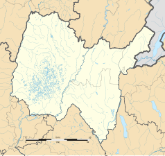 | |||
Położenie na mapie Francji  | |||
Położenie na mapie regionu Owernia-Rodan-Alpy  | |||
| Strona internetowa | |||
.svg)
Pont-d’Ain – miejscowość i gmina we Francji, w regionie Owernia-Rodan-Alpy, w departamencie Ain.
Demografia
[edytuj | edytuj kod]Według danych na styczeń 2012 roku gminę zamieszkiwały 2722 osoby, a gęstość zaludnienia wynosiła 242,6 osób/km².
Galeria
[edytuj | edytuj kod]-
 Dworzec kolejowy (2009 r.)
 -
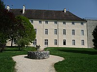 Zamek (2009 r.)
.JPG)
Bibliografia
[edytuj | edytuj kod]Linki zewnętrzne
[edytuj | edytuj kod]Text is available under the CC BY-SA 4.0 license; additional terms may apply.
Images, videos and audio are available under their respective licenses.
Cover photo is available under {{::mainImage.info.license.name || 'Unknown'}} license.
Cover photo is available under {{::mainImage.info.license.name || 'Unknown'}} license.
Credit:
(see original file).
