Plik:Pra River.gif
Grafika w wyższej rozdzielczości nie jest dostępna.
Pra_River.gif (564 × 599 pikseli, rozmiar pliku: 117 KB, typ MIME: image/gif, zapętlony, 3 klatki, 0,3 s)
| Plik Pra River.gif znajduje się w Wikimedia Commons – repozytorium wolnych zasobów. Dane z jego strony opisu znajdują się poniżej. |
Opis
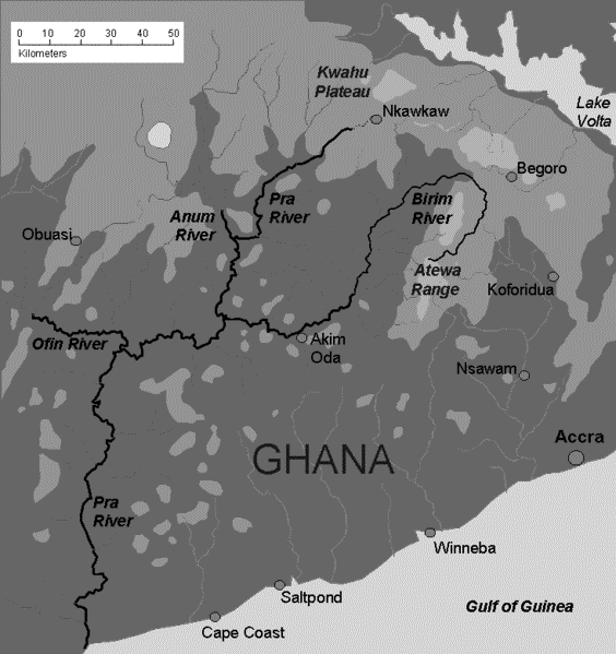
| Opis | Sketch map of Pra river in Ghana and tributaries |
| Data | |
| Źródło | Praca własna |
| Autor | Aymatth2 |
Licencja
| Ja, właściciel praw autorskich do tej pracy, udostępniam ją jako własność publiczną. Dotyczy to całego świata. W niektórych krajach może nie być to prawnie możliwe, jeśli tak, to: Zapewniam każdemu prawo do użycia tej pracy w dowolnym celu, bez żadnych ograniczeń, chyba że te ograniczenia są wymagane przez prawo. |
Historia pliku
Kliknij na datę/czas, aby zobaczyć, jak plik wyglądał w tym czasie.
| Data i czas | Miniatura | Wymiary | Użytkownik | Opis | |
|---|---|---|---|---|---|
| aktualny | 23:53, 29 lis 2012 | | 564 × 599 (117 KB) | Ciaurlec | Desaturated to make topography more readble. |
| 04:13, 22 mar 2009 |  | 734 × 780 (28 KB) | Aymatth2 | ((Information |Description=Sketch map of Pra river in Ghana and tributaries |Source=self-made |Date=2009-03-20 |Author= Aymatth2 |Permission= |other_versions= )) Category:Geological maps |
Lokalne wykorzystanie pliku
Poniższa strona korzysta z tego pliku:
Globalne wykorzystanie pliku
Ten plik jest wykorzystywany także w innych projektach wiki:
- Wykorzystanie na ast.wikipedia.org
- Wykorzystanie na cv.wikipedia.org
- Wykorzystanie na en.wikipedia.org
- Wykorzystanie na es.wikipedia.org
- Wykorzystanie na fr.wikipedia.org
- Wykorzystanie na gpe.wikipedia.org
- Wykorzystanie na ha.wikipedia.org
- Wykorzystanie na lt.wikipedia.org
- Wykorzystanie na ru.wikipedia.org
- Wykorzystanie na simple.wikipedia.org
- Wykorzystanie na zh.wikipedia.org
Text is available under the CC BY-SA 4.0 license; additional terms may apply.
Images, videos and audio are available under their respective licenses.
Cover photo is available under {{::mainImage.info.license.name || 'Unknown'}} license.
Cover photo is available under {{::mainImage.info.license.name || 'Unknown'}} license.
Credit:
(see original file).
