For faster navigation, this Iframe is preloading the Wikiwand page for Plik:Poland administrative divisions (1999).svg.

Plik:Poland administrative divisions (1999).svg

Rozmiar pierwotny(Plik SVG, nominalnie 1000 × 931 pikseli, rozmiar pliku: 1,82 MB)

Opis

Opis
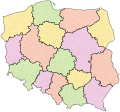
English: Map of Polish voivodeships as of 1 January 1999.
Legend: gray lines – commune borders, black borders – voivodeship borders.
Polski: Mapa województw według stanu z 1 stycznia 1999 roku.
Legenda: szare linie – granice gmin, czarne linie – granice województw.
Data
Źródło Ustawa z dnia 24 lipca 1998 r. o wprowadzeniu zasadniczego trójstopniowego podziału terytorialnego państwa (Dz.U. 1998 nr 96 poz. 603).
Autor TexLacerta

Licencja

Ja, właściciel praw autorskich do tego dzieła, udostępniam je na poniższej licencji
w:pl:Licencje Creative Commons
uznanie autorstwa
Ten plik udostępniony jest na licencji Creative Commons Uznanie autorstwa 4.0 Międzynarodowe.
Wolno:
  • dzielić się – kopiować, rozpowszechniać, odtwarzać i wykonywać utwór
  • modyfikować – tworzyć utwory zależne
Na następujących warunkach:
  • uznanie autorstwa – musisz określić autorstwo utworu, podać link do licencji, a także wskazać czy utwór został zmieniony. Możesz to zrobić w każdy rozsądny sposób, o ile nie będzie to sugerować, że licencjodawca popiera Ciebie lub Twoje użycie utworu.

Podpisy

Dodaj jednolinijkowe objaśnienie tego, co ten plik pokazuje

Obiekty przedstawione na tym zdjęciu

przedstawia

Historia pliku

Kliknij na datę/czas, aby zobaczyć, jak plik wyglądał w tym czasie.

Data i czasMiniaturaWymiaryUżytkownikOpis
aktualny20:09, 17 sty 2024Miniatura wersji z 20:09, 17 sty 20241000 × 931 (1,82 MB)TexLacertabez granic powiatów
20:07, 17 sty 2024Miniatura wersji z 20:07, 17 sty 20241000 × 931 (2,46 MB)TexLacerta== ((int:filedesc)) == ((Information |description=((en|1=Map of Polish voivodeships and counties as of 1 January 1999.<br/>Legend: gray lines – commune borders, medium-width borders – county borders, black borders – voivodeship borders, darker background – cities with county rights.)) ((pl|1=Mapa województw i powiatów według stanu z 1 stycznia 1999 roku.<br/>Legenda: szare linie – granice gmin, linie średniej grubości – granice powiatów, czarne linie – granice województw, ciemniejsze tło – mi...

Lokalne wykorzystanie pliku

Metadane

{{bottomLinkPreText}} {{bottomLinkText}}
Plik:Poland administrative divisions (1999).svg
Listen to this article

This browser is not supported by Wikiwand :(
Wikiwand requires a browser with modern capabilities in order to provide you with the best reading experience.
Please download and use one of the following browsers:

This article was just edited, click to reload
This article has been deleted on Wikipedia (Why?)

Back to homepage

Please click Add in the dialog above
Please click Allow in the top-left corner,
then click Install Now in the dialog
Please click Open in the download dialog,
then click Install
Please click the "Downloads" icon in the Safari toolbar, open the first download in the list,
then click Install
{{::$root.activation.text}}

Install Wikiwand

Install on Chrome Install on Firefox
Don't forget to rate us

Tell your friends about Wikiwand!

Gmail Facebook Twitter Link

Enjoying Wikiwand?

Tell your friends and spread the love:
Share on Gmail Share on Facebook Share on Twitter Share on Buffer

Our magic isn't perfect

You can help our automatic cover photo selection by reporting an unsuitable photo.

This photo is visually disturbing This photo is not a good choice

Thank you for helping!


Your input will affect cover photo selection, along with input from other users.

X

Get ready for Wikiwand 2.0 🎉! the new version arrives on September 1st! Don't want to wait?