Plik:OttomanEmpire1801.jpg
Rozmiar pierwotny (1638 × 1296 pikseli, rozmiar pliku: 605 KB, typ MIME: image/jpeg)
| Plik OttomanEmpire1801.jpg znajduje się w Wikimedia Commons – repozytorium wolnych zasobów. Dane z jego strony opisu znajdują się poniżej. |

Opis
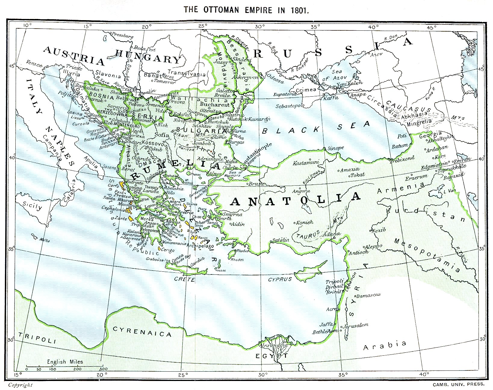
Ottoman Empire (green) and Septinsular Republic (yellow) in 1801.
Licencja
|
Ten materiał przeszedł do domeny publicznej w kraju pochodzenia, jak również w państwach i terytoriach, gdzie prawo autorskie wygasa w ciągu 70 lat po śmierci autora.
| |
| Plik rozpoznano jako wolny od znanych ograniczeń praw autorskich, włącznie z prawami zależnymi i pokrewnymi. | |
Historia pliku
Kliknij na datę/czas, aby zobaczyć, jak plik wyglądał w tym czasie.
| Data i czas | Miniatura | Wymiary | Użytkownik | Opis | |
|---|---|---|---|---|---|
| aktualny | 18:06, 11 sty 2023 | | 1638 × 1296 (605 KB) | Enyavar | Reverted to version as of 08:56, 11 March 2006 (UTC) --> even if they are wrong, don't change historical maps! |
| 19:48, 3 lut 2014 |  | 1638 × 1296 (518 KB) | Spiridon Ion Cepleanu | Some little changes according with the 1801 situation : The Septinsular Rep. includes Ionian Is., not the Cyclades, Serbia became autonomous 1817... | |
| 10:56, 11 mar 2006 |  | 1638 × 1296 (605 KB) | Julo | Ottoman Empire (green) & Septinsular Republic (yellow) in 1801, on the 19th century map ((PD-old)) category:19th century mapsCategory:Historical maps of the Middle EastCategory:Historical maps of the Balkans[[Category:Historical maps of Africa |
Lokalne wykorzystanie pliku
Poniższa strona korzysta z tego pliku:
Globalne wykorzystanie pliku
Ten plik jest wykorzystywany także w innych projektach wiki:
- Wykorzystanie na azb.wikipedia.org
- Wykorzystanie na ba.wikipedia.org
- Wykorzystanie na el.wikipedia.org
- Wykorzystanie na en.wikipedia.org
- Wykorzystanie na fr.wikipedia.org
- Wykorzystanie na hy.wikipedia.org
- Wykorzystanie na la.wikipedia.org
- Wykorzystanie na sq.wikipedia.org
- Wykorzystanie na sv.wikipedia.org
- Wykorzystanie na uk.wikipedia.org
Metadane
Text is available under the CC BY-SA 4.0 license; additional terms may apply.
Images, videos and audio are available under their respective licenses.
