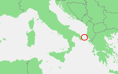
Plik:Locatie Straat van Otranto.PNG
Grafika w wyższej rozdzielczości nie jest dostępna.
Locatie_Straat_van_Otranto.PNG (378 × 236 pikseli, rozmiar pliku: 8 KB, typ MIME: image/png)
| Plik Locatie Straat van Otranto.PNG znajduje się w Wikimedia Commons – repozytorium wolnych zasobów. Dane z jego strony opisu znajdują się poniżej. |
| Opis | In dutch: Locatie Straat van Otranto.PNG | ||||
| Źródło | own work based on PD map | ||||
| Autor | edited by M.Minderhoud | ||||
| Licencja (Ponowne użycie tego pliku) |
|
Historia pliku
Kliknij na datę/czas, aby zobaczyć, jak plik wyglądał w tym czasie.
| Data i czas | Miniatura | Wymiary | Użytkownik | Opis | |
|---|---|---|---|---|---|
| aktualny | 22:10, 19 lut 2010 | | 378 × 236 (8 KB) | Telim tor | focussing on object |
| 20:21, 12 wrz 2006 |  | 473 × 430 (16 KB) | Michiel1972 | ((Information |Description=In dutch: ((subst:PAGENAME)) |Source= own work based on PD map |Date= |Author= edited by M.Minderhoud |Permission= ((PD-Demis)) |other_versions= )) category:Locator maps of seas |
Lokalne wykorzystanie pliku
Poniższa strona korzysta z tego pliku:
Globalne wykorzystanie pliku
Ten plik jest wykorzystywany także w innych projektach wiki:
- Wykorzystanie na ar.wikipedia.org
- Wykorzystanie na ca.wikipedia.org
- Wykorzystanie na ckb.wikipedia.org
- Wykorzystanie na cy.wikipedia.org
- Wykorzystanie na de.wikipedia.org
- Wykorzystanie na en.wikipedia.org
- Wykorzystanie na es.wikipedia.org
- Wykorzystanie na fo.wikipedia.org
- Wykorzystanie na fr.wikipedia.org
- Wykorzystanie na fy.wikipedia.org
- Wykorzystanie na hu.wikipedia.org
- Wykorzystanie na nl.wikipedia.org
- Wykorzystanie na pl.wiktionary.org
- Wykorzystanie na pt.wikipedia.org
- Wykorzystanie na tr.wikipedia.org
- Wykorzystanie na vls.wikipedia.org
Text is available under the CC BY-SA 4.0 license; additional terms may apply.
Images, videos and audio are available under their respective licenses.
Cover photo is available under {{::mainImage.info.license.name || 'Unknown'}} license.
Cover photo is available under {{::mainImage.info.license.name || 'Unknown'}} license.
Credit:
(see original file).
