Plik:Guam ali 2011364 lrg.jpg
Rozmiar pierwotny (3994 × 5148 pikseli, rozmiar pliku: 4,36 MB, typ MIME: image/jpeg)
| Plik Guam ali 2011364 lrg.jpg znajduje się w Wikimedia Commons – repozytorium wolnych zasobów. Dane z jego strony opisu znajdują się poniżej. |
Opis
| Opis |
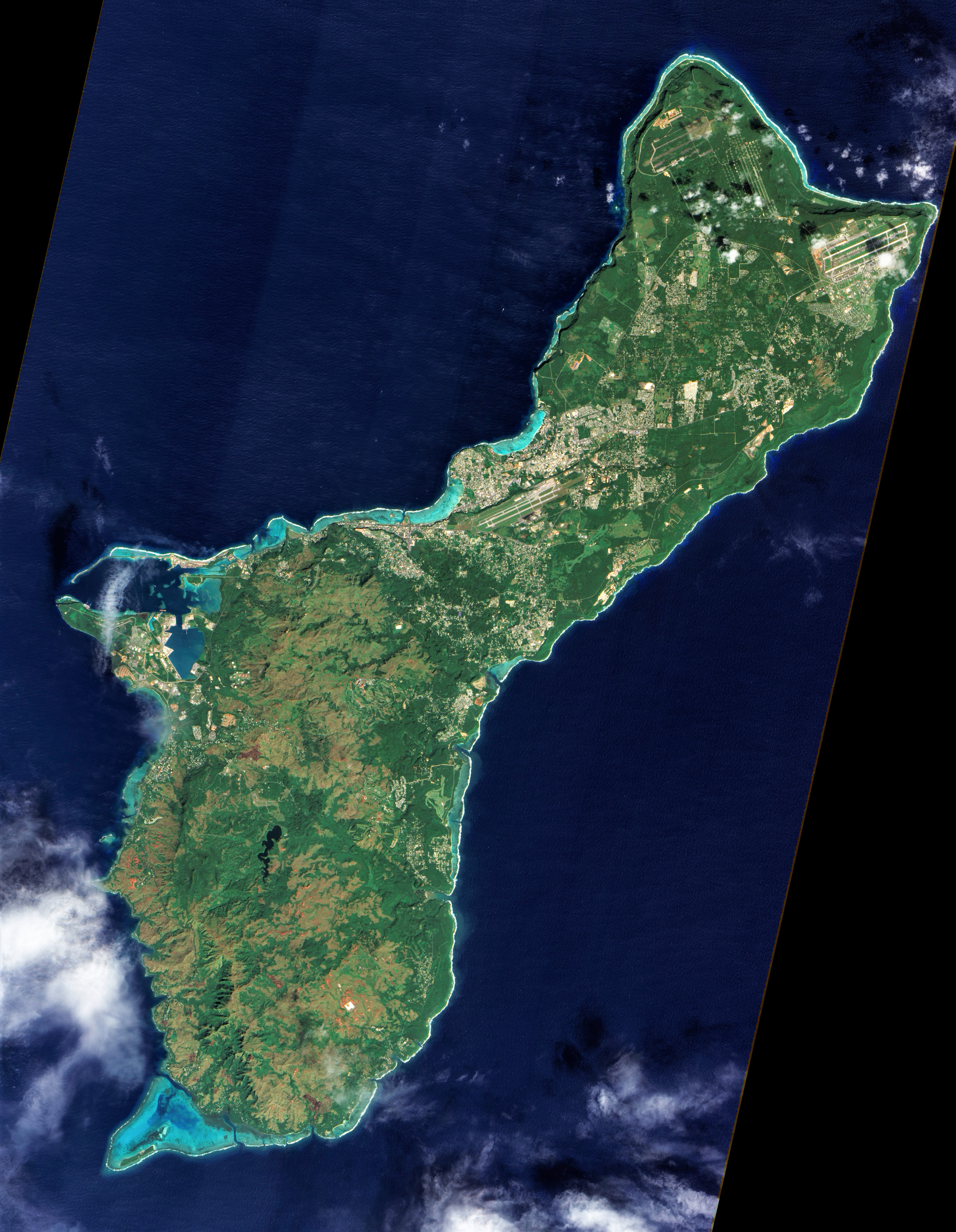
English: On December 30, 2011, cloud-free skies presented NASA’s Earth Observing-1 (EO-1) satellite with this unobstructed view of the island of Guam. Note that this image, taken by the satellite’s Advanced Land Imager (ALI), has been rotated and north is at right.
Located in the tropical Pacific Ocean, the U.S. territory of Guam lies at the southern end of the Mariana Island Chain. As the largest island in that archipelago, Guam stretches roughly 30 miles (50 kilometers) from northeast to southwest. Fields, forests, military bases, and settlements all mix on the landscape. Two prominent airstrips run northeast-southwest, one at the northeastern tip of the island, and the other in central Guam. Guam has two seasons: wet (June to December) and dry (January to June), and ALI acquired this image during the transition from wet to dry. The fate of that rainwater has a lot to do with whether it lands in the northern or southern part of the island. In southern Guam, volcanic rock predominates, but in northern Guam, limestone overlies volcanic rock. Limestone is porous—so porous, in fact, that practically all the water in northern Guam infiltrates the rock. After percolating through the limestone, water in northern Guam becomes part of the groundwater system. Guam’s rivers are confined to the southern part of the island, where less porous volcanic rock enables water to collect on the surface. Coral reefs fringe the island, and they are especially visible around Apra Harbor and Cocos Lagoon. Shallow water along these reefs glows peacock blue. Not far from Guam, the ocean is anything but shallow. Just east of the Mariana Islands lies the Mariana Trench. Located at the boundary between tectonic plates, it is the deepest point in the Earth’s ocean. References
NASA Earth Observatory image created by Jesse Allen and Robert Simmon, using EO-1 ALI data provided courtesy of the NASA EO-1 team and the United States Geological Survey. Caption by Michon Scott. Instrument: EO-1 - ALI |
| Data | |
| Źródło | http://earthobservatory.nasa.gov/IOTD/view.php?id=77189 |
| Autor | NASA |
| Inne wersje |
.jpg)
Licencja
| Ten plik jest w domenie publicznej ponieważ został stworzony przez NASA. Polityka praw autorskich NASA stwierdza, że „materiały NASA nie są chronione prawami autorskimi, chyba że zapisano inaczej”. (NASA copyright policy lub JPL Image Use Policy). | ||
 |
Uwaga:
|
Historia pliku
Kliknij na datę/czas, aby zobaczyć, jak plik wyglądał w tym czasie.
| Data i czas | Miniatura | Wymiary | Użytkownik | Opis | |
|---|---|---|---|---|---|
| aktualny | 10:16, 24 maj 2020 | | 3994 × 5148 (4,36 MB) | Beyond My Ken | Adjs for visibility |
| 00:53, 20 lut 2012 |  | 4014 × 6021 (4,45 MB) | Melikamp |
Lokalne wykorzystanie pliku
Poniższa strona korzysta z tego pliku:
Globalne wykorzystanie pliku
Ten plik jest wykorzystywany także w innych projektach wiki:
- Wykorzystanie na br.wikipedia.org
- Wykorzystanie na bs.wikipedia.org
- Wykorzystanie na en.wikipedia.org
- Wykorzystanie na fa.wikipedia.org
- Wykorzystanie na fo.wikipedia.org
- Wykorzystanie na id.wikipedia.org
- Wykorzystanie na incubator.wikimedia.org
- Wykorzystanie na ko.wikipedia.org
- Wykorzystanie na ml.wikipedia.org
- Wykorzystanie na nl.wikipedia.org
- Wykorzystanie na tl.wikipedia.org
- Wykorzystanie na tr.wikipedia.org
- Wykorzystanie na zh-yue.wikipedia.org
- Wykorzystanie na zh.wikipedia.org
Metadane
Text is available under the CC BY-SA 4.0 license; additional terms may apply.
Images, videos and audio are available under their respective licenses.
