Monbéqui
| miejscowość i gmina | |||
 Ratusz. | |||
| |||
| Państwo | |||
|---|---|---|---|
| Region | |||
| Departament | |||
| Okręg | |||
| Kod INSEE |
82114 | ||
| Powierzchnia |
6,83 km² | ||
| Populacja (1990) • liczba ludności |
| ||
| • gęstość |
40 os./km² | ||
| Kod pocztowy |
82170 | ||
Położenie na mapie Tarn i Garonny  | |||
Położenie na mapie Francji  | |||
Położenie na mapie Oksytanii  | |||
| Strona internetowa | |||
.svg)
Monbéqui – miejscowość i gmina we Francji, w regionie Oksytania, w departamencie Tarn i Garonna.
Według danych na rok 1990 gminę zamieszkiwały 273 osoby, a gęstość zaludnienia wynosiła 40 osób/km² (wśród 3020 gmin regionu Midi-Pireneje Monbéqui plasuje się na 791. miejscu pod względem liczby ludności, natomiast pod względem powierzchni na miejscu 1339.).
Zabytki
[edytuj | edytuj kod]-
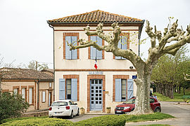 Ratusz
 -
 Pomnik wojenny
 -
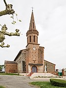 kościół


Bibliografia
[edytuj | edytuj kod]- Francuski urząd statystyczny. (fr.).
Text is available under the CC BY-SA 4.0 license; additional terms may apply.
Images, videos and audio are available under their respective licenses.
Cover photo is available under {{::mainImage.info.license.name || 'Unknown'}} license.
Cover photo is available under {{::mainImage.info.license.name || 'Unknown'}} license.
Credit:
(see original file).
