Königsfeld (Bawaria)
| gmina | |||

| |||
| |||
| Państwo | |||
|---|---|---|---|
| Kraj związkowy | |||
| Rejencja | |||
| Powiat | |||
| Kod statystyczny |
09 4 71 151 | ||
| Powierzchnia |
42,72 km² | ||
| Wysokość |
460 m n.p.m. | ||
| Populacja (31 grudnia 2011) • liczba ludności |
| ||
| • gęstość |
31 os./km² | ||
| Numer kierunkowy |
09207 | ||
| Kod pocztowy |
96167 | ||
| Tablice rejestracyjne |
BA | ||
Adres urzędu: Hauptstraße 2196167 Königsfeld | |||
Położenie na mapie powiatu
| |||
| 49°57′N 11°10′E/49,950000 11,166667 | |||
| Strona internetowa | |||

Königsfeld – miejscowość i gmina w Niemczech, w kraju związkowym Bawaria, w rejencji Górna Frankonia, w regionie Oberfranken-West, w powiecie Bamberg, wchodzi w skład wspólnoty administracyjnej Steinfeld. Leży w Szwajcarii Frankońskiej, około 20 km na północny wschód od Bamberga, nad rzeką Aufseß, przy drodze B22.
Dzielnice
[edytuj | edytuj kod]W skład gminy wchodzą następujące dzielnice:

|

|
Huppendorf | 143 |

|

|
Königsfeld | 569 |

|
_Ortsmitte_4.jpg)
|
Kotzendorf | 107 |

|
Laibarös | 148 | |

|
Poxdorf | 159 | |

|

|
Treunitz | 160 |

|

|
Voitmannsdorf | 125 |
Położenie
[edytuj | edytuj kod]Königsfeld graniczy z następującymi gminami:
- Litzendorf (na zachodzie)
- Scheßlitz (na północnym zachodzie)
- Stadelhofen (na północy)
- Hollfeld (na wschodzie)
- Heiligenstadt in Oberfranken (na południu)
Zabytki i atrakcje
[edytuj | edytuj kod]- Kościół pw. św. Jakuba i Katarzyny (St. Jakobus und Katharina)
- Kaplica św. Anny (St. Anna)
- kaplica w dzielnicy Laibarös
- źródło rzeki Aufseß
Galeria
[edytuj | edytuj kod]-
 Kościół św. Jakuba i Katarzyny (St, Jakobus und Katharina)
 -
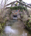 Źródło Aufseß
 -
 Panorama Königsfelda


| Miasta | |
|---|---|
| Gminy targowe | |
| Gminy | |
| Obszary wolne administracyjnie | |
| Wspólnoty administracyjne |

Text is available under the CC BY-SA 4.0 license; additional terms may apply.
Images, videos and audio are available under their respective licenses.
Cover photo is available under {{::mainImage.info.license.name || 'Unknown'}} license.
Cover photo is available under {{::mainImage.info.license.name || 'Unknown'}} license.
Credit:
(see original file).
