Augrabies Falls
 Augrabies Falls | |
| Kontynent | |
|---|---|
| Państwo | |
| Typ |
kaskadowy |
| Wysokość |
56 m |
| Liczba strug |
1 |
| Średni przepływ |
313 m³/s |
| Rzeka zasilająca | |
Położenie na mapie Prowincji Przylądkowej Północnej  | |
Położenie na mapie Południowej Afryki  | |
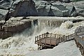
Augrabies Falls – wodospad na rzece Oranje, w Prowincji Przylądkowej Północnej, w Południowej Afryce, na terenie Parku Narodowego Augrabies Falls. Ogólna wysokość wodospadu wynosi 56 m[1]. Niektóre źródła podają wysokość 146 m, która jest liczona od dna kanionu do szczytu ścian, a nie samego wodospadu[1]. Miejscowy lud Khoikhoi nazywa go „Ankoerebis”, co znaczy „miejsce wielkich hałasów”. Od tej miejscowej nazwy Burowie, którzy tu później przybyli, nadali wodospadowi dzisiejszą nazwę „Augrabies”[2].
Rekordowe przepływy przez wodospad zanotowano w czasie powodzi w 1988 roku – 7800 m³/s – i 6800 m³/s w 2006 roku. Było to ponad 3 razy więcej od średniego przepływu przez wodospad Niagara w okresie największych opadów, wynoszącego ok. 2400 m³/s[3].
Kanion przy wodospadzie Augrabies Falls ma głębokość 240 m i długość 18 km. Jest on przykładem erozji granitu.
Galeria
[edytuj | edytuj kod]-
 Wodospad w czasie powodzi
 -
 Wodospad z platformy widokowej
 -
-
 Pomosty przy wodospadzie
 -
 Moon Rocks
 -
 Wodospad w porze suchej


Przypisy
[edytuj | edytuj kod]- ↑ a b Augrabies Falls | World Waterfall Database. www.worldwaterfalldatabase.com. [dostęp 2017-02-21].
- ↑ Natural Wonders of the World. Richard L. Scheffel (edit.), Susan J. Wernet (edit.). United States of America: Reader's Digest Association, Inc, 1980, s. 62. ISBN 0-89577-087-3.
- ↑ Augrabies Falls, Northern Cape, South Africa. www.theworldwonders.com. [dostęp 2017-11-07].
Text is available under the CC BY-SA 4.0 license; additional terms may apply.
Images, videos and audio are available under their respective licenses.
