Alpy Ennstalskie
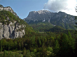
 Hochtor | |
| Kontynent | |
|---|---|
| Państwo | |
| Najwyższy szczyt |
Hochtor |
| Jednostka dominująca | |
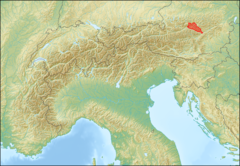
 Położenie na mapie Alp; granice pasma według Alpenvereinseinteilung der Ostalpen (1984)[1] | |
Położenie na mapie Europy  | |
Alpy Ennstalskie[2] (niem. Ennstaler Alpen) – pasmo górskie w Północnych Alpach Wapiennych. Leży w Austrii, w krajach związkowych Styria i Górna Austria. Najwyższym szczytem jest Hochtor, który osiąga 2369 m. Głównym miastem regionu jest Eisenerz.
Pasmo graniczy[1] z: Oberösterreichische Voralpen[3] na północy, Ybbstaler Alpen[3] na północnym wschodzie, Hochschwabgruppe na wschodzie, Lavanttaler Alpen na południowym wschodzie, Seckauer Tauern na południu, Rottenmanner und Wölzer Tauern na południowym zachodzie oraz z Totes Gebirge na zachodzie.
Najwyższe szczyty:
|
|
Schroniska:
- Hesshütte (1699 m)
- Buchsteinhaus (1546 m)
- Haindkar Hütte (1121 m)
- Ennstaler Hütte (1544 m)
- Mödlinger Hütte (1523 m)
- Rohrauer Haus (1308 m)

Przypisy
[edytuj | edytuj kod]- ↑ a b Podział Alp Wschodnich według Alpenverein: Alpenvereinseinteilung der Ostalpen (1984). [dostęp 2014-07-20].
- ↑ Główny Urząd Geodezji i Kartografii: Urzędowy wykaz polskich nazw geograficznych świata, s. 9; Komisja Standaryzacji Nazw Geograficznych poza Granicami Rzeczypospolitej Polskiej przy Głównym Geodecie Kraju, Warszawa, 2013. [dostęp 2014-07-20]. [zarchiwizowane z tego adresu (2014-05-07)].
- ↑ a b Główny Urząd Geodezji i Kartografii nie podaje polskiego egzonimu tego pasma: Urzędowy wykaz polskich nazw geograficznych świata, ss. 9-10; Komisja Standaryzacji Nazw Geograficznych poza Granicami Rzeczypospolitej Polskiej przy Głównym Geodecie Kraju, Warszawa, 2013. [dostęp 2014-07-20]. [zarchiwizowane z tego adresu (2014-05-07)].
Bibliografia
[edytuj | edytuj kod]- Günter Auferbauer, Luise Auferbauer: Gesäuse mit Eisenerzer Alpen.. Ottobrunn: Bergverlag Rother, 2001. ISBN 3-7633-4213-3.
- Hubert Wolf, Josef Hasitschka: Gesäuse mit Eisenerzer Alpen.. Graz: Bergverlag Rother, 2002. ISBN 3-222-12997-5.
- Ernst Kren: Gesäuse. Steirische Verlagsgesellschaft. Graz: 2002. ISBN 3-85489-081-8.
Text is available under the CC BY-SA 4.0 license; additional terms may apply.
Images, videos and audio are available under their respective licenses.

