Béie d'Sonme
 Carte deul Côte d'Opale aveuc l' béie d'Sonme | |||||
| Jografie humaine | |||||
| Poéyis côtiers | |||||
| Subdivisions territoriales | départémint : Sonme région Heuts-d'Franche | ||||
| Jografie fysike | |||||
| Type | Béie | ||||
| Localisacion | Manche | ||||
| Coordonnées | |||||
| Superfichie | 70 km2 | ||||
Géolocalisacion édseur el carte : France
Géolocalisacion édseur el carte : Hauts-de-France
Géolocalisacion édseur el carte : Somme
| |||||
| modifier |
|||||


L' béie d'Sonme est plachée édzeur ch' littoral éd la Picardie (Heuts-d'Franche). Ch'est un liu aveuc ène grande richesse écologike notammint pour l' ornitologie.
L' béie d'Sonme (70 km2) est située intre l' pointe du Hourdel au sud et pi l' pointe d' Saint-Quentin-in-Tourmont au nord. L' Sonme (fleufe côtier qui a donné sin nom à ch' départémint), s' jette dins el Manche ichi.
L' béie est principalemint constituée pèr deus milieux :
- el slikke, zone d' vasières, ercouverte pèr l' mér deus foés pèr jour,
- ech schorre o « mollières » couvert pèr l' mér seulemint pindant chés grandes marées.
L' béie est constituée pèr deus estuaires imboétès :
 |
 |
Réserve naturelle nationale del béie d'Sonme
[éditer | modifier ech wikicode]Ch'est ène zone d' 3 000 ha qu' est concintrèe, essinciellemint in zone maritime, édpis l' novelle pointe d' Saint-Quentin-in-Tourmont à l'imbouchure éd la Mèye, tiot fleufe côtier débouchant au nord deul béie d'Sonme.
-
 Ch' goéland arginté.
 -
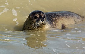
 Un foque.
 -
-
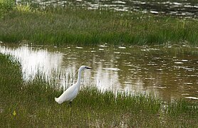 Eune aigrette garzette.


Grand site de France
[éditer | modifier ech wikicode]L' béie d'Sonme est labellisée « Grand Site de France » au 15 ed join 2011.
Parc naturel marin
[éditer | modifier ech wikicode]L' béie d'Sonme fait partie du Parc naturel marin des éstuaires picards pi deul mér d'Opale créè in déchimbe 2012. Chole parc naturel marin, situé au large deul Seine maritime, éd la Somme et pi du Pas-d'Calés, concerne 118 km éd côtes et pi sèt éstuaires :
Notes pi référinches
[éditer | modifier ech wikicode]Vir itou
[éditer | modifier ech wikicode]- Réserve naturelle nacionale del Béie d'Sonme
- Parc du Marquintière
- Chl' Hâble d'Eut
- Parc naturel marin des éstuaires picards pi deul mér d'Opale
- Moéson deul Béie d'Sonme et pi deul oizo
- Cmin d" fer deul Béie d'Sonme
|
Text is available under the CC BY-SA 4.0 license; additional terms may apply.
Images, videos and audio are available under their respective licenses.
