For faster navigation, this Iframe is preloading the Wikiwand page for File:IntertropicalConvergenceZone-EO.jpg.

File:IntertropicalConvergenceZone-EO.jpg
Fail original(2,772 × 1,250 pixel, tamaño di fail: 1.54 MB, MIME type: image/jpeg)

E fail akí ta di Wikimedia Commons i por us'é den otro proyekto. E deskripshon riba su página di deskripshon di fail ta indiká mas abou.

Resúmen

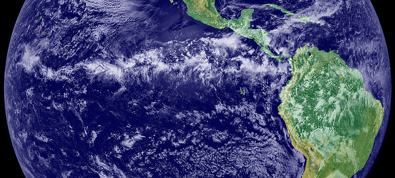
The Intertropical Convergence Zone (ITCZ), is the region that circles the Earth, near the equator, where the trade winds of the Northern and Southern Hemispheres come together. The intense sun and warm water of the equator heats the air in the ITCZ, raising its humidity and causing it to rise. As the air rises it cools, releasing the accumulated moisture in an almost perpetual series of thunderstorms.

Variation in the location of the ITCZ drastically affects rainfall in many equatorial nations, resulting in the wet and dry seasons of the tropics rather than the cold and warm seasons of higher latitudes. Longer term changes in the ITCZ can result in severe droughts or flooding in nearby areas.

Credit/source

This image is a combination of cloud data from NOAA’s newest Geostationary Operational Environmental Satellite (GOES-11) and color land cover classification data. The ITCZ is the band of bright white clouds that cuts across the center of the image.

http://earthobservatory.nasa.gov/IOTD/view.php?id=703

Lisensia

Public domain This file is in the public domain in the United States because it was solely created by NASA. NASA copyright policy states that "NASA material is not protected by copyright unless noted". (See Template:PD-USGov, NASA copyright policy page or JPL Image Use Policy.)
Warnings:

Captions

Add a one-line explanation of what this file represents

Items portrayed in this file

ta portretá

Historia di fail

Klek riba un fecha/ora pa mira e fail, manera e tabata na e momentu ei.

Fecha/OraMiniaturaDimenshonnanUsuarioKomentario
aktual17:45, 12 yüni 2005Miniatura di e vershon di 17:45, 12 yüni 20052,772 × 1,250 (1.54 MB)Gustavo Carrancio~commonswikiPic from http://earthobservatory.nasa.gov/Newsroom/NewImages/images.php3?img_id=4028 File history Nasa photo with no especific Copyright

Uso di fail

E próksimo page uses ta uza e fail akí:

Uso global di fail

E próksimo otro wikinan ta usa e fail akí

Mira mas uzo global di e fail akí.

Metadato

{{bottomLinkPreText}} {{bottomLinkText}}
File:IntertropicalConvergenceZone-EO.jpg
Listen to this article

This browser is not supported by Wikiwand :(
Wikiwand requires a browser with modern capabilities in order to provide you with the best reading experience.
Please download and use one of the following browsers:

This article was just edited, click to reload
This article has been deleted on Wikipedia (Why?)

Back to homepage

Please click Add in the dialog above
Please click Allow in the top-left corner,
then click Install Now in the dialog
Please click Open in the download dialog,
then click Install
Please click the "Downloads" icon in the Safari toolbar, open the first download in the list,
then click Install
{{::$root.activation.text}}

Install Wikiwand

Install on Chrome Install on Firefox
Don't forget to rate us

Tell your friends about Wikiwand!

Gmail Facebook Twitter Link

Enjoying Wikiwand?

Tell your friends and spread the love:
Share on Gmail Share on Facebook Share on Twitter Share on Buffer

Our magic isn't perfect

You can help our automatic cover photo selection by reporting an unsuitable photo.

This photo is visually disturbing This photo is not a good choice

Thank you for helping!


Your input will affect cover photo selection, along with input from other users.

X

Get ready for Wikiwand 2.0 🎉! the new version arrives on September 1st! Don't want to wait?