Lublin Voivodeship


Lakanbalen at balen
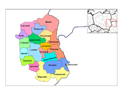
[mag-edit | alilan ya ing pikuwanan]Ing voivodeship atin yang 4a lakanbalen at balen, deng apat a lakanbalen ausan dalang lakanbalen counties. Ing tala keng lalam sasalesen nala agpang keng dakal ningpoplasyun (agpang manibat Disisembri 31, 2005):
 Lublin – 358.967 (147,50 km²)
 Chełm – 72.595 (35,26 km²)
 Zamość – 66.802 (30,48 km²)
 Biała Podlaska – 59.047 (49,41 km²)
 Puławy – 51.515 (50,61 km²)
 Świdnik – 40.041 (20,35 km²)
 Kraśnik – 36.170 (25,28 km²)
 Łuków – 30.612 (35,75 km²)
 Biłgoraj – 27.208 (20,85 km²)
 Lubartów – 23.017 (13,92 km²)
 Łęczna – 21.767 (18,98 km²)
 Tomaszów Lubelski – 20.170 (13,33 km²)
 Krasnystaw - 19.531 (42,07 km²)
 Hrubieszów - 18.633 (32,79 km²)
 Dęblin - 18.150 (38,51 km²)
 Międzyrzec Podlaski - 17.193 (19,75 km²)
 Radzyń Podlaski - 16.135 (19,29 km²)
 Włodawa - 15.724 (18,67 km²)
 Janów Lubelski - 11.947 (15,42 km²)
 Parczew - 10.286 (8,05 km²)
 Poniatowa - 9.983 (15,20 km²)
 Ryki - 9.730 (27,38 km²)
 Opole Lubelskie - 8.842 (14,83 km²)
 Bełżyce - 7.090 (23,46 km²)
 Terespol - 5.981 (10,20 km²)
 Szczebrzeszyn - 5.305 (29,04 km²)
 Bychawa - 5.304 (6,68 km²)
 Rejowiec Fabryczny - 4.537 (14,36 km²)
 Nałęczów - 4.266 (13,84 km²)
 Kazimierz Dolny - 3.584 (30,42 km²)
 Kock - 3.497 (16,79 km²)
 Tarnogród - 3.372 (10,86 km²)
 Zwierzyniec - 3.339 (4,84 km²)
 Krasnobród - 3.027 (6,99 km²)
 Stoczek Łukowski - 2.718 (9,13 km²)
 Annopol - 2.681 (7,75 km²)
 Piaski - 2.642 (8,44 km²)
 Józefów - 2.453 (5,28 km²)
 Tyszowce - 2.263 (18,52 km²)
 Ostrów Lubelski - 2.253 (29,68 km²)
 Frampol - 1.427 (4,67 km²)
Bantug a apelidu king labuad
[mag-edit | alilan ya ing pikuwanan]- Wójcik : 12,937
- Mazurek : 9,644
- Mazur : 8,019
Suglung Palwal
[mag-edit | alilan ya ing pikuwanan]- Biala Podlaska
- Lublin Voivodeship official website
- Adam Mickiewicz Institute page on Jewish history in Lublin Region
Template:LublinVoivodshipCounties Template:Voivodeships of Poland
Text is available under the CC BY-SA 4.0 license; additional terms may apply.
Images, videos and audio are available under their respective licenses.


