ମେଘନା ନଦୀ

ମେଘନା ନଦୀ(ବଙ୍ଗଳା: মেঘনা নদী) ବାଂଲାଦେଶର ସବୁଠାରୁ ଗୁରୁତ୍ୱପୂର୍ଣ ନଦୀ । ,[୧] ବଂଗୋପମହାସାଗରକୁ ଲାଗି ରହିଥିବା ଗାଙ୍ଗେୟ ସମତଳଭୂମି ଅଞ୍ଚଳରେ ପ୍ରବାହିତ ତିନିଟି ମୁଖ୍ୟ ନଦୀ ମଧ୍ୟରୁ ଏହା ଅନ୍ୟତମ । ସୁରମା - ମେଘାନା ନଦୀ ପ୍ରଣାଳୀର ମେଘନା ନଦୀର ଉପତ୍ତି ବାଂଲାଦେଶର କିଶୋରଗଞ୍ଜ ଜିଲ୍ଲାର ଭୈରବ ବଜାର ସହରର ଉପର ଅଞ୍ଚଳରେ ସୁର୍ମା ନଦୀ ଓ କୁଶିୟାରା ନଦୀର ସଙ୍ଗମଦ୍ୱାରା ସୃଷ୍ଟି ହେଇଥାଏ । ସୁର୍ମା ଓ କୁଶିୟାରା ପୂର୍ବ ଭାରତୀୟ ପାର୍ବତ୍ୟ ଅଞ୍ଚଳରୁ ଉପତ୍ତି ଘଟି ବାରକ ନଦୀ ଭାବରେ ଆସିଥାଏ । ଚାଁଦପୁର ଜିଲ୍ଲାରେ ମେଘନା ନଦୀ ତାହାର ମୁଖ୍ୟ ଉପନଦୀ ପଦ୍ମା ସହ ମିଳିତ ହୁଏ । ମେଘନା ନଦୀର ଅନନ୍ୟ ଉପନଦୀଗୁଡ଼ିକ ହେଲା ଢାଲେସବାରି , ଗୁମଟିଓ ଫେଣି । ମେଘନା ନଦୀ ଭୋଳା ଜିଲ୍ଲା ରରେ ବଂଗୋପ ସାଗରରେ ଲୀନ ହୁଏ । ଏହାର ମୁହାଣ ଅଞ୍ଚଳରେ ତେତୁଳିଆ , ଶବାଜପୁର , ହଟିଆ ଓ ବାମ୍ଣୀ ରହିଛି ।

ବାଂଲାଦେଶ ଭିତରେ ସମ୍ପୂର୍ଣ ଭାବରେ ପ୍ରବାହିତ ନଦୀଗୁଡ଼ିକ ମଧ୍ୟରୁ ମେଘନା ସବୁଠାରୁ ବେଶୀ ପ୍ରସ୍ଥ ବିଶିଷ୍ଟ । ଭୋଳା ନିକଟରେ ଏହାର ପ୍ରସ୍ଥ 12 କିଲୋମିଟର ହେଇଥାଏ । ତଳ ମୁଣ୍ଡରେ ଏହି ନଦୀ ସମତଳ ଭୂମିରେ ସରଳରେଖା ପରି ପ୍ରବାହିତ ହେଇଥାଏ ।
ଗତିପଥ
[ସମ୍ପାଦନା]ପୂର୍ବ ଭାରତୀୟ ପାର୍ବତ୍ୟ ଇଲାକାରୁ ସୁର୍ମା ଓ କୁଶିୟାରା ନଦୀ ଉପତ୍ତି ହେଇ ଚାଁଦପୁରଠାରେ ମିଳିତ ହେଲା ପରେ ଏହା ମେଘନା ନାମ ଧାରଣ କରି ପ୍ରବାହିତ ହେଇ ପଦ୍ମା ନଦୀ ସହ ମିଳିତ ହୁଏ । ମୂଳଧୂଳି ନାମକ ସ୍ଥାନରୁ ଏହି ନଦୀରୁ ଏକ ଶାଖା ନଦୀ ବାହାରି "ସାଫିପୁର ନଦୀ" ସୃଷ୍ଟି ହେଇଥାଏ ।
ବ୍ରାହ୍ମଣବାରି ଜିଲ୍ଲାର ଘଟଲପୁରଠାରେ ମେଘନା ନଦୀରୁ ଆଉ ଏକ ଶାଖା ନଦୀ "ତିଳସ " ବାହାରି ଥାଏ । ଏହା 240 କିଲୋମିଟର ବକ୍ର ଭାବରେ ଗତି କଲାପରେ ପୁନଶ୍ଚ ମେଘନା ସହ ନବୀନପୁର ଉପଜିଲ୍ଲା ଅଞ୍ଚଳରେ ମିଳିତ ହେଇଯାଏ । ଏହି ଟିଳସ ନଦୀ ଗୋଟିଏ ଧାରା ହେଇ ବାହାରି , ପରେ ଦୁଇଟି ଭିନ୍ନ ଧାରା ହେଇ ପ୍ରବାହିତ ହେଇଥାଏ ।

କୋମିଲ୍ଲା ଜିଲ୍ଲାର ଦଉଡଖଣ୍ଡି ଅଞ୍ଚଳରେ ମେଘନା ସହ ଗୁମତି ନଦୀର ମିଳନ ହେଇ ନଦୀର ଜଳଧାରା ବହୁ ପରିମାଣରେ ବୃଦ୍ଧି ପାଇଥାଏ । ମେଘନା ଓ ଗୁମତି ଉପରେ ଥିବା ଦ୍ୱୈତ ସେତୁ ବାଂଲାଦେଶର ଦୀର୍ଘତମ ସେତୁ ।
ଚାଁଦପୁରଠାରେ ପୁନର୍ବାର ମେଘନା ନଦୀର କାୟା ବୃଦ୍ଧି ଘଟିଥାଏ ଢାଲେଶ୍ୱରୀ ନଦୀ ସହ ମିଶ୍ରଣ ଯୋଗୁଁ । ତଳକୁ ପ୍ରବାହିତ ହେଇ ଏହା ତାହାର ସର୍ବ ବୃହତ ଉପନଦୀ ପଦ୍ମା[୨] ସହ ଚାଁଦପୁର ଜିଲ୍ଲାର ତଳ ଅଂଶ ରେ ମିଳିତ ହୁଏ ।
ଏଠାରେ ମେଘନା ନଦୀର ନିର୍ମଲା ଜଳ ପ୍ରବାହ ସହ ପଦ୍ମା ନଦୀର ଧୂସର ଓ ଗୋଳିଆ ପାଣି ଧାରା ସମ୍ପୂର୍ଣ ଭାବରେ ମିଶି ନ ଯାଇ ସମାନ୍ତରାଳ ଭାବେ ଯାଉଥିବାର ଦେଖାଯାଏ । ଏହା ଏକ ଖୁବ ଆକର୍ଷକ ଦୃଶ୍ୟ ସୃଷ୍ଟି କରିଥାଏ ।
ଚାଁଦପୁର ତଳକୁ ପଦ୍ମା , ମେଘନା ଓ ଯମୁନା ନଦୀର ସମ୍ମିଳିତ ପ୍ରବାହ ଯାଇ ବଙ୍ଗୋପସାଗରରେ ଏକ ସରଳରେଖା ସଦୃଶ ଯାଇ ପାତନ ହେଇଥାଏ । ସମୁଦ୍ରରେ ମିଳିତ ହେବା ଆଗରୁ ମ୍ମେଘନାର ଅନେକ ଧାରା ବିଭିନ୍ନ ସ୍ଥାନରେ ବାହାରି ଭିନ୍ନ ଦିଗରେ ଗତି କରି ପୁନର୍ବାର ମେଘନା ସହ ମିଳିତ ହେଇଥାନ୍ତି ।
ଭୋଳା ନିକଟରେ ସମୁଦ୍ରରେ ପଡିବା ଠିକ ଆଗରୁ ଏହା ଦୁଇଟି ସ୍ରୋତ ହେଇ ମଝିରେ ଏକ ଦ୍ୱିପାଞ୍ଚଳ ସୃଷ୍ଟି କରିଥାଏ । ଏଠାରେ ପଶ୍ଚିମ ସ୍ରୋତକୁ ଇଶା କୁହାଯାଉଥିବା ବେଳେ ପୂର୍ବ ସ୍ରୋତକୁ ବାମ୍ଣୀ କୁହାଯାଏ ।[୩][୪]
ମେଘନା ବେସିନ ଅଞ୍ଚଳର ଜଳବାଯୁ
[ସମ୍ପାଦନା]ମେଘନା ବେସିନ ଅଞ୍ଚଳ ବ୍ରହ୍ମପୁତ୍ର - ଗଙ୍ଗା- ମେଘନା (BGM)ଦ୍ୱାରା ସୃଷ୍ଟି ହେଇଥିବା ବିଶ୍ୱର ଏକ ବୃହତ୍ତମ ସମତଳ ଭୂମି ତଥା ବୃହତ ବଙ୍ଗୀୟ ସମତଳର ଏକ ମୁଖ୍ୟ ଅଂଶ । ସେଠାରେ ଜଳବାଯୁ ଅତ୍ୟନ୍ତ ପରିବର୍ତନଶୀଳ ହେଇଥାଏ । ବର୍ଷ କାଳରେ ବନ୍ୟା ବିପତ୍ତି ବହୁ ସମୟରେ ରହିଥାଏ । [୫] ପ୍ରତିବର୍ଷ ଜୁଲାଇରୁ ଅକ୍ଟୋବର ମାସ ଯାଏ ସେଠାରେ ସର୍ବଦା ବାତ୍ୟାର ଆଶଙ୍କା ଥାଏ ।
ଗେଲେରି
[ସମ୍ପାଦନା]-
 Meghna River by Mashroor Nitol
 -
 Landscape of meghna river
 -
 Line of water
 -
 Charfasson, Bangladesh
 -
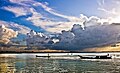
 Overcrowded ferry boat on Meghna River, Bangladesh


ପୁନଶ୍ଚ ଦେଖଣା
[ସମ୍ପାଦନା]- List of rivers in Bangladesh
ଆଧାର
[ସମ୍ପାଦନା]- ↑ Masud Hasan Chowdhury (2012). "Meghna River". In Sirajul Islam and Ahmed A. Jamal (ed.). Banglapedia: National Encyclopedia of Bangladesh (Second ed.). Asiatic Society of Bangladesh.
- ↑ Padma and Jamuna (the name of the Brahmaputra in Bangladesh) rivers near Chandpur. After a course of about 164 miles (264 km) it enters the Bay of Bengal by four principal mouths—Tetulia, Shahbazpur, Hatia, and Bamni. Major tributaries are the Dhaleswari, the Gumti (the name of the Gomati in Bangladesh), and the Feni, https://www.britannica.com/place/Meghna-River
- ↑ The Barak river divides into two branches within the Assam state in India. The northern branch is called Surma, which flows southwards through the eastern side of Bangladesh next Sylhet town. The southern branch is called Kushiara, which flows through India and then enters Bangladesh. First the northern branch joins the Meghna river near Kuliar Char and then the southern branch joins the Meghna river near Ajmiriganj. The lower Meghna river is one of the largest rivers in the world, being the mouth of the three great rivers: Ganges-Padma, Brahmaputra and Meghna. The total length of the river is about 930 km. The river is predominantly a meandering channel, but in several reaches, especially where small tributaries contribute sediment, braiding is evident with sand islands bifurcating the river into two or more channels
- ↑ www.fao.org/nr/water/aquastat/basins/gbm/gbm-CP_eng.pdf
- ↑ whereas the world’s highest precipitation area is situated in the Meghna river basin (Mirza et al., 2011).
Text is available under the CC BY-SA 4.0 license; additional terms may apply.
Images, videos and audio are available under their respective licenses.
