ଫାଇଲ:Mapa-in-jk-okresy-cislovane.png
ବଡ଼ ରେଜୋଲୁସନ ନାହିଁ ।
Mapa-in-jk-okresy-cislovane.png (୪୦୧ × ୩୩୨ ପିକସେଲ, ଫାଇଲ ଆକାର: ୫୫ KB, ଏମ.ଆଇ.ଏମ.ଇର ପ୍ରକାର: image/png)
This is a file from the Wikimedia Commons. Information from its description page there is shown below. |
| ବିବରଣୀ |
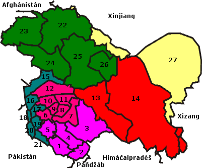
Čeština: Mapa státu Džammú a Kašmír (Indie), včetně částí spravovaných Pákistánem a Čínou, s vyznačením hranic okresů. Okresy jsou očíslované, legendu lze vytvořit v libovolném jazyce.
English: Districts of states Jammu and Kashmir (India) with part administered by Pakistan and China with marked border. |
||
| ତାରିଖ | ୧୦ ଅପ୍ରେଲ ୨୦୦୫ (original upload date) | ||
| ମୂଳାଧାର | Transferred from cs.wikipedia to Commons by sevela.p. | ||
| ଲେଖକ | The original uploader was Zeman at ଚେକ୍ ଉଇକିପିଡ଼ିଆ. | ||
| ଅନୁମତି (ଏହି ଫାଇଲକୁ ପୁଣି ବ୍ୟବହାର କରିବେ) |
|
ମୂଲ ଅପଲୋଡ଼ ଫାଇଲ
The original description page was here. All following user names refer to cs.wikipedia.
- 2005-04-10 18:45 Zeman 401×332×8 (56424 bytes) Mapa státu D?ammú a Ka?mír (Indie), v?etn? ?ástí spravovaných Pákistánem a ?ínou, s vyzna?ením hranic okres?. Okresy jsou o?íslované, legendu lze vytvo?it v libovolném jazyce. ((PD-self))
ଫାଇଲ ଇତିହାସ
ଏହା ଫାଇଲଟି ସେତେବେଳେ ଯେମିତି ଦିଶୁଥିଲା ତାହା ଦେଖିବା ପାଇଁ ତାରିଖ/ବେଳା ଉପରେ କ୍ଲିକ କରନ୍ତୁ
| ତାରିଖ/ବେଳ | ନଖ ଦେଖଣା | ଆକାର | ବ୍ୟବହାରକାରୀ | ମତାମତ | |
|---|---|---|---|---|---|
| ଏବେକାର | ୨୨:୦୫, ୧୮ ଫେବୃଆରୀ ୨୦୦୮ | | ୪୦୧ × ୩୩୨ (୫୫ KB) | File Upload Bot (Magnus Manske) | ((BotMoveToCommons|cs.wikipedia)) ((Information |Description=((cs|Mapa státu D?ammú a Ka?mír (Indie), v?etn? ?ástí spravovaných Pákistánem a ?ínou, s vyzna?ením hranic okres?. Okresy jsou o?íslované, legendu lze vytvo?it v libovolném jazyce. |
ଫାଇଲ ବ୍ୟବହାର
ଏହି ପୃଷ୍ଠାଟି ଏହି ଫାଇଲ ସହ ଜଡ଼ିତ:
ଜଗତ ଫାଇଲ ବ୍ୟବହାର
ତଳଲିଖିତ ଉଇକିସବୁ ଏହି ଫାଇଲଟିକୁ ବ୍ୟବହାର କରିଥାନ୍ତି:
- cs.wikipedia.orgରେ ବ୍ୟବହାର
- hi.wikipedia.orgରେ ବ୍ୟବହାର
- kn.wikipedia.orgରେ ବ୍ୟବହାର
- mai.wikipedia.orgରେ ବ୍ୟବହାର
- ne.wikipedia.orgରେ ବ୍ୟବହାର
- te.wikipedia.orgରେ ବ୍ୟବହାର
Text is available under the CC BY-SA 4.0 license; additional terms may apply.
Images, videos and audio are available under their respective licenses.
Cover photo is available under {{::mainImage.info.license.name || 'Unknown'}} license.
Cover photo is available under {{::mainImage.info.license.name || 'Unknown'}} license.
Credit:
(see original file).
