For faster navigation, this Iframe is preloading the Wikiwand page for Fil:Political map of England 1153.PNG.

Fil:Political map of England 1153.PNG
Opprinnelig fil(1 489 × 1 753 piksler, filstørrelse: 217 KB, MIME-type: image/png)

Beskrivelse

Beskrivelse
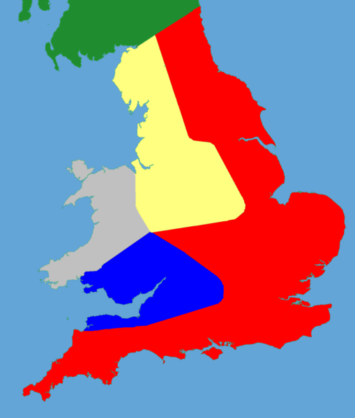
English: A political map of southern Britain in 1153
Dato (UTC)
Kilde

Own work using:

Opphavsperson


This is a retouched picture, which means that it has been digitally altered from its original version. Modifications: Trimmed and historical details added. The original can be viewed here: Gb4dot.svg. Modifications made by Hchc2009.

Jeg, rettighetsinnehaver av dette arbeidet, publiserer det herved under følgende lisens:
Public domain Jeg, opphavsrettensholderen til dette verket, frigir dette verket til allmennheten. Dette gjelder på verdensbasis.
I enkelte land kan dette være juridisk umulig. I så fall:
Jeg gir hvem som helst retten til å bruke dette verket for ethvert formål, uten noen vilkår, med mindre slike vilkår kreves ved lov.

Orginal opplastningslogg

This image is a derivative work of the following images:

  • File:Gb4dot.svg licensed with PD-self
    • 2006-08-08T17:40:31Z Wereon 1104x1586 (1035991 Bytes) de-Inkscaped; de-emphasized rivers
    • 2006-08-08T17:37:07Z Wereon 1104x1586 (1038283 Bytes)

Uploaded with derivativeFX

Bildetekster

Legg til en kort forklaring på hva filen representerer

Elementer som er med i denne fila

motiv

222 440 byte

1 753 piksel

1 489 piksel

image/png

da82a0318ba52a2a3aa6fdec8bbdc35a9d08250a

Filhistorikk

Klikk på et tidspunkt for å vise filen slik den var på det tidspunktet.

Dato/klokkeslettMiniatyrbildeDimensjonerBrukerKommentar
nåværende27. mai 2011 kl. 20:03Miniatyrbilde av versjonen fra 27. mai 2011 kl. 20:031 489 × 1 753 (217 KB)Hchc2009((Information |Description=A blank locator map for Great Britain. The idea is to superimpose Image:dot4gb.svg at the appropriate point. See w:Template:GBthumb for code to do this. These two images can replace any locator map posted by Lupin - se

Filbruk

Den følgende siden bruker denne filen:

Global filbruk

Følgende andre wikier bruker denne filen:

{{bottomLinkPreText}} {{bottomLinkText}}
Fil:Political map of England 1153.PNG
Listen to this article

This browser is not supported by Wikiwand :(
Wikiwand requires a browser with modern capabilities in order to provide you with the best reading experience.
Please download and use one of the following browsers:

This article was just edited, click to reload
This article has been deleted on Wikipedia (Why?)

Back to homepage

Please click Add in the dialog above
Please click Allow in the top-left corner,
then click Install Now in the dialog
Please click Open in the download dialog,
then click Install
Please click the "Downloads" icon in the Safari toolbar, open the first download in the list,
then click Install
{{::$root.activation.text}}

Install Wikiwand

Install on Chrome Install on Firefox
Don't forget to rate us

Tell your friends about Wikiwand!

Gmail Facebook Twitter Link

Enjoying Wikiwand?

Tell your friends and spread the love:
Share on Gmail Share on Facebook Share on Twitter Share on Buffer

Our magic isn't perfect

You can help our automatic cover photo selection by reporting an unsuitable photo.

This photo is visually disturbing This photo is not a good choice

Thank you for helping!


Your input will affect cover photo selection, along with input from other users.

X

Get ready for Wikiwand 2.0 🎉! the new version arrives on September 1st! Don't want to wait?