Fil:Near East 1400 BCE.png
Størrelse på denne forhåndsvisningen: 750 × 600 piksler. Andre oppløsninger: 300 × 240 piksler | 600 × 480 piksler | 785 × 628 piksler.
Opprinnelig fil (785 × 628 piksler, filstørrelse: 146 KB, MIME-type: image/png)
| Denne filen er fra Wikimedia Commons og kan brukes av andre prosjekter. Informasjonen fra filbeskrivelsessiden vises nedenfor. |

|
Dette bildet bør gjenskapes med hjelp av vektorgrafikk som en SVG-fil. Dette har flere fordeler, se Commons:Media for cleanup for mer informasjon. Hvis en SVG-fil med dette bildet er tilgjengelig, vennligst last den opp. Etter opplasting erstatt denne malen med ((vector version available|nytt bilde.svg)).
|
Beskrivelse
| Beskrivelse |
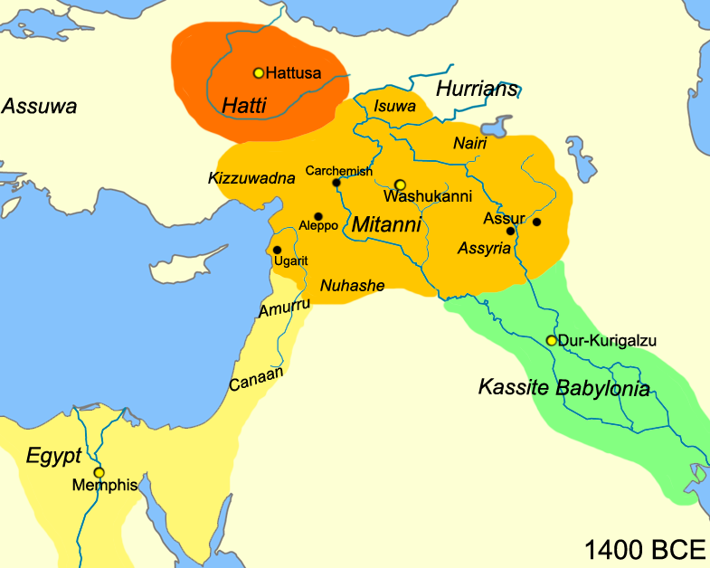
English: Map of the near east circa 1400 BCE.
עברית: מפת אזור המזרח הקרוב חלוקה לאימפריות בשנת 1400 לפנה"ס |
| Dato | |
| Kilde |
Eget verk
|
| Opphavsperson | Javierfv1212 |
| Andre versjoner |
[]
|


Lisensiering
| Dette verket har blitt frigitt til allmennheten av opphavspersonen Javierfv1212 at engelsk Wikipedia. Dette gjelder på verdensbasis. I enkelte land kan dette være juridisk umulig. I så fall: Javierfv1212 gir hvem som helst retten til å bruke dette verket for ethvert formål, uten noen vilkår, med mindre slike vilkår kreves ved lov. |
Orginal opplastningslogg
The original description page was here. All following user names refer to en.wikipedia.
- 2010-03-21 22:10 Javierfv1212 785×628× (149438 bytes) ((Information |Description = Map of the near east circa 1400 BCE. |Source = I (~~~) created this work entirely by myself. Source: Cambridge Ancient History Vol II Middle East & Aegean Region 1800-1300. I. E. S. EDWARDS (Ed) et al. |Date
Filhistorikk
Klikk på et tidspunkt for å vise filen slik den var på det tidspunktet.
| Dato/klokkeslett | Miniatyrbilde | Dimensjoner | Bruker | Kommentar | |
|---|---|---|---|---|---|
| nåværende | 3. jul. 2010 kl. 17:41 | | 785 × 628 (146 KB) | Hanay | ((Information |Description=((en|1=Map of the near east circa 1400 BCE. )) ((he|1=מפת אזור המזרח הקרוב חלוקה לאימפריות בשנת 1400 לפנה"ס)) |Source=http://en.wikipedia.org/wiki/File:Near_East_1400_BCE.png |Author=[[Use |
Filbruk
De følgende 2 sidene bruker denne filen:
Global filbruk
Følgende andre wikier bruker denne filen:
- Bruk i af.wikipedia.org
- Bruk i ast.wikipedia.org
- Bruk i azb.wikipedia.org
- Bruk i az.wikipedia.org
- Bruk i be-tarask.wikipedia.org
- Bruk i bg.wikipedia.org
- Bruk i bn.wikipedia.org
- Bruk i ca.wikipedia.org
- Bruk i ceb.wikipedia.org
- Bruk i cs.wikipedia.org
- Bruk i cv.wikipedia.org
- Bruk i da.wikipedia.org
- Bruk i el.wikipedia.org
- Bruk i en.wikipedia.org
- Bruk i en.wiktionary.org
- Bruk i et.wikipedia.org
- Bruk i fa.wikipedia.org
- Bruk i fr.wikipedia.org
- Bruk i he.wikipedia.org
- Bruk i hr.wikipedia.org
- Bruk i hy.wikipedia.org
- Bruk i hyw.wikipedia.org
- Bruk i incubator.wikimedia.org
- Bruk i it.wikipedia.org
Vis mer global bruk av denne filen.
Text is available under the CC BY-SA 4.0 license; additional terms may apply.
Images, videos and audio are available under their respective licenses.
Cover photo is available under {{::mainImage.info.license.name || 'Unknown'}} license.
Cover photo is available under {{::mainImage.info.license.name || 'Unknown'}} license.
Credit:
(see original file).
