Fil:Atlantic cable Map.jpg
Størrelse på denne forhåndsvisningen: 800 × 322 piksler. Andre oppløsninger: 320 × 129 piksler | 640 × 257 piksler.
Opprinnelig fil (1 493 × 600 piksler, filstørrelse: 163 KB, MIME-type: image/jpeg)
| Denne filen er fra Wikimedia Commons og kan brukes av andre prosjekter. Informasjonen fra filbeskrivelsessiden vises nedenfor. |
| Beskrivelse |
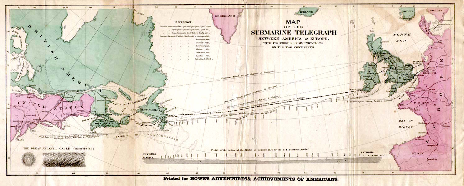
English: Map of the 1858 Atlantic Cable route (from http://atlantic-cable.com/Maps/index.htm).
Français : Carte des routes de câbles sous-marins transatlatiques de 1858.
Русский: Карта прокладки телеграфного кабеля через Атлантику в 1858 г.
Українська: Карта першого трансатлантичного телеграфного кабеля в 1858 р. |
| Dato | the 1858 |
| Kilde | Howe's Adventures & Achievements of Americans; en:Image:Atlantic_cable_Map.jpg |
| Opphavsperson | Ukjent |
| Tillatelse (Gjenbruk av denne filen) |
English: Image is out of copyright, but the scan used here was sourced from http://atlantic-cable.com/Maps/index.htm without my permission (I am the site owner). I grant permission for use of the scan on Wikipedia.
Українська: Зображення не захищене авторським правом, але сканування, яке тут використовується, було отримано з http://atlantic-cable.com/Maps/index.htm без мого дозволу (я власник сайту). Надаю дозвіл на використання сканування у Вікіпедії. |
|
Dette verket er offentlig eiendom i Norge, EU og land der den opphavsrettslige vernetiden etter opphavsmannens død er 70 år eller kortere. Merk at noen land har lengre vernetid. | |
| Denne filen har blitt identifisert til å være fri for kjente restriksjoner under lov om opphavsrett, inkludert alle relaterte og nærstående rettigheter. | |
This media file is in the public domain in the United States. This applies to U.S. works where the copyright has expired, often because its first publication occurred prior to January 1, 1929, and if not then due to lack of notice or renewal. See this page for further explanation.
|
 | |
 |
Filhistorikk
Klikk på et tidspunkt for å vise filen slik den var på det tidspunktet.
| Dato/klokkeslett | Miniatyrbilde | Dimensjoner | Bruker | Kommentar | |
|---|---|---|---|---|---|
| nåværende | 29. jan. 2018 kl. 16:35 | 1 493 × 600 (163 KB) | Soerfm | Color, brightness | |
| 9. mar. 2006 kl. 17:53 | 1 493 × 600 (136 KB) | Jailbird | Map of the 1858 Atlantic Cable route from Frank Leslie's Illustrated Newspaper, August 21, 1858 from en:Image:Atlantic_cable_Map.jpg ((PD-Old)) |
Filbruk
De følgende 3 sidene bruker denne filen:
Global filbruk
Følgende andre wikier bruker denne filen:
- Bruk i az.wikipedia.org
- Bruk i be-tarask.wikipedia.org
- Bruk i bs.wikipedia.org
- Bruk i ca.wikipedia.org
- Bruk i cs.wikipedia.org
- Bruk i de.wikipedia.org
- Bruk i en.wikipedia.org
- Bruk i en.wikibooks.org
- Bruk i en.wikivoyage.org
- Bruk i eo.wikipedia.org
- Bruk i es.wikipedia.org
- Bruk i et.wikipedia.org
- Bruk i eu.wikipedia.org
- Bruk i fa.wikipedia.org
- Bruk i fi.wikipedia.org
- Bruk i fr.wikipedia.org
- 1866
- Câble sous-marin
- Extel
- Câbles télégraphiques transatlantiques
- Discussion:Câbles télégraphiques transatlantiques
- Wikipédia:Statistiques des anecdotes de la page d'accueil/Visibilité des anecdotes (2021)
- Discussion:Câbles télégraphiques transatlantiques/LSV 19995
- Wikipédia:Statistiques des anecdotes de la page d'accueil/Visibilité des anecdotes (2021)/2021 04
- Projet:Aide et accueil/Twitter/Tweets/archives/avril 2021
- Wikipédia:Le saviez-vous ?/Archives/2021
- Wikipédia:Le Bistro/5 août 2022
- Télégraphie électrique
- Bruk i gd.wikipedia.org
- Bruk i id.wikipedia.org
- Bruk i io.wikipedia.org
- Bruk i it.wikipedia.org
- Bruk i ja.wikipedia.org
Vis mer global bruk av denne filen.
Metadata
Text is available under the CC BY-SA 4.0 license; additional terms may apply.
Images, videos and audio are available under their respective licenses.
Cover photo is available under {{::mainImage.info.license.name || 'Unknown'}} license.
Cover photo is available under {{::mainImage.info.license.name || 'Unknown'}} license.
Credit:
(see original file).
