Fil:Rs-map.png
Høgare oppløysing er ikkje tilgjengeleg.
Rs-map.png (634 × 323 pikslar, filstorleik: 37 KB, MIME-type: image/png)
Følgjande er henta frå filomtalen åt denne fila på Wikimedia Commons:
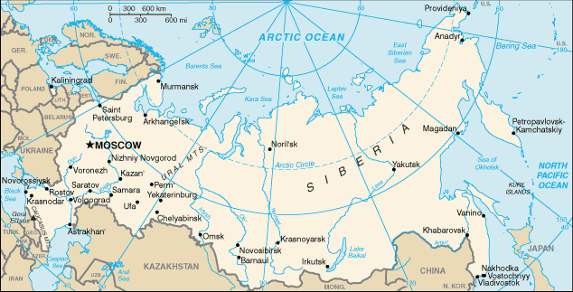
CIA map of Russia. https://www.cia.gov/library/publications/the-world-factbook/geos/rs.html archive copy at the Wayback Machine
This version of CIA World Factbook map has few changes compared to the previous version at Commons.
See also SVG version: Image:Blank map of Russia-geoloc.svg
Dette biletet er offentleg eigedom av di det inneheld tilfang som kjem frå Sambandsstatanes Central Intelligence Agency si Allkunnebok over verda.
|
 |
| Annotations | This image is annotated: View the annotations at Commons |
Filhistorikk
Klikk på dato/klokkeslett for å sjå fila slik ho var på det tidspunktet.
| Dato/klokkeslett | Miniatyrbilete | Oppløysing | Brukar | Kommentar | |
|---|---|---|---|---|---|
| gjeldande | 16. mai 2009 kl. 18:40 | | 634 × 323 (37 KB) | Pasixxxx | New version of this map from CIA World Factbook site. Few more cities, Yekaterinburg location has changed considerably compared to the Commons' previous version. From CIA World Factbook site [https://www.cia.gov/library/publications/the-world-factbook/geo |
| 3. desember 2004 kl. 17:50 |  | 635 × 324 (29 KB) | Kneiphof | CIA map of Russia, PD |
Filbruk
Dei følgjande 2 sidene bruker denne fila:
Global filbruk
Desse andre wikiane nyttar fila:
- Bruk på als.wikipedia.org
- Bruk på ar.wikipedia.org
- Bruk på ast.wikipedia.org
- Bruk på az.wiktionary.org
- Bruk på ceb.wikipedia.org
- Bruk på cs.wikipedia.org
- Bruk på de.wikipedia.org
- Bruk på diq.wikipedia.org
- Bruk på dsb.wikipedia.org
- Bruk på en.wikipedia.org
- Wikipedia:In the news/Candidates/December 2005
- List of twin towns and sister cities in Russia
- Wikipedia:Reference desk/Archives/Science/2007 July 18
- Northern river reversal
- Energy in Russia
- User:Epipelagic/sandbox/ref3
- Module talk:Location map/Archive 1
- User:Andrewjlockley/Hydraulic geoengineering2g
- User:Morriswa/My OCONUS travel
- User:Falcaorib/Russia and Soviet Union
- Bruk på en.wikibooks.org
- Bruk på en.wiktionary.org
- Bruk på es.wikipedia.org
- Bruk på fr.wikipedia.org
- Bruk på gl.wikipedia.org
- Bruk på he.wikipedia.org
- Bruk på hif.wikipedia.org
- Bruk på hu.wikipedia.org
- Bruk på id.wikipedia.org
Sjå meir global bruk av denne fila.
Text is available under the CC BY-SA 4.0 license; additional terms may apply.
Images, videos and audio are available under their respective licenses.
Cover photo is available under {{::mainImage.info.license.name || 'Unknown'}} license.
Cover photo is available under {{::mainImage.info.license.name || 'Unknown'}} license.
Credit:
(see original file).
