Trepassey Bay (Canada)
| Trepassey Bay | ||||
|---|---|---|---|---|
 | ||||
| Situering | ||||
| Locatie | Newfoundland | |||
| Coördinaten | 46° 40′ NB, 53° 20′ WL | |||
| Basisgegevens | ||||
| Oppervlakte | ca. 175 km² | |||
| Soort water | Baai | |||
| Overig | ||||
| Plaatsen | Trepassey, Portugal Cove South, Biscay Bay | |||
| ||||
Trepassey Bay is een baai van zo'n 175 km² in de Canadese provincie Newfoundland en Labrador. De baai ligt in het uiterste zuidoosten van het eiland Newfoundland.
Geografie
[bewerken | brontekst bewerken]Trepassey Bay ligt aan de zuidkust van het schiereiland Avalon, hetwelk het meest zuidoostelijke deel van Newfoundland is. De baai gaat zo'n 15 km landinwaarts en heeft op z'n breedste punt een doorsnee van 25 km.
Er liggen zes plaatsen langsheen Trepassey Bay, allen gelegen aan de noordkust ervan. Het betreft van west naar oost Daniel's Point, Shoal Point, Trepassey, Lower Coast, Biscay Bay en Portugal Cove South. Deze plaatsen hadden anno 2021 tezamen zo'n 600 inwoners.[1]
Galerij
[bewerken | brontekst bewerken]-
 Amerikaanse marineschepen in Trepassey Bay in mei 1919
 -
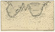 Nautische kaart uit 1869 van het noordelijke deel van de baai (zuiden ligt bovenaan)

_p0694_TREPASSEY_BAY.jpg)
Bronnen, noten en/of referenties
- ↑ (en)
 Statistics Canada, '2021 Census Population, by 2016 Census Consolidated Subdivision (CCS) by Community, Newfoundland and Labrador', 2022.
Text is available under the CC BY-SA 4.0 license; additional terms may apply.
Images, videos and audio are available under their respective licenses.
Cover photo is available under {{::mainImage.info.license.name || 'Unknown'}} license.
Cover photo is available under {{::mainImage.info.license.name || 'Unknown'}} license.
Credit:
(see original file).
