Pilisgebergte
| Pilisgebergte | ||||
|---|---|---|---|---|

| ||||
Locatie van Pilisgebergte in Hongarije
| ||||
| Hoogste punt | Pilis (757 m) | |||
| Locatie | Hongarije | |||
| Coördinaten | 47° 44′ NB, 18° 55′ OL | |||
| Onderdeel van | Transdanubisch Middelgebergte | |||
 | ||||
Het Pilisgebergte (Pilis hegység) ligt in het noorden van Hongarije tussen de Donauknie (Duna-Kanyar) in het noordoosten, en loopt uit in de heuvels van Boedapest. Naar het westen uit, vloeit het samen met het Bakonygebergte.
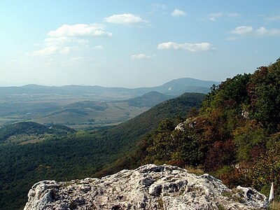
Dit gebergte is interessant vanwege de natuurpracht en de vergezichten. De op een na hoogste top is de Dobogókö van 700 meter hoog. De hoogste berg van het Pilisgebergte is de Pilis zelf, met zijn 757 meter hoogte. Het stadje Piliscsaba en de stad Pilisvörösvár liggen aan de voet van deze hoge heuvel. Het gebergte is begroeid met bomen en planten en heeft geen kale toppen.
-
 Pilisgebergte
 -
 De Pilis


Text is available under the CC BY-SA 4.0 license; additional terms may apply.
Images, videos and audio are available under their respective licenses.
Cover photo is available under {{::mainImage.info.license.name || 'Unknown'}} license.
Cover photo is available under {{::mainImage.info.license.name || 'Unknown'}} license.
Credit:
(see original file).
