Lapleau
| Gemeente in Frankrijk | |||
|---|---|---|---|
.svg) | |||
 | |||
| Situering | |||
| Regio | Nouvelle-Aquitaine | ||
| Departement | Corrèze (19) | ||
| Arrondissement | Tulle | ||
| Kanton | Égletons | ||
| Coördinaten | 45° 17′ NB, 2° 10′ OL | ||
| Algemeen | |||
| Oppervlakte | 17,76 km² | ||
| Inwoners (1 januari 2021) |
373[1] (21 inw./km²) | ||
| Hoogte | 280 - 583 m | ||
| Overig | |||
| Postcode | 19550 | ||
| INSEE-code | 19106 | ||
| Website | Officiële website | ||
| Detailkaart | |||
 | |||
| |||
Lapleau is een gemeente in het Franse departement Corrèze (regio Nouvelle-Aquitaine) en telt 525 inwoners (1999). De plaats maakt deel uit van het arrondissement Tulle.
-
 Kerk van Lapleau
 -
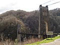 Viaduc des Rochers Noirs


Geografie
[bewerken | brontekst bewerken]De oppervlakte van Lapleau bedraagt 17,7 km², de bevolkingsdichtheid is 29,7 inwoners per km². Een niet meer in gebruik zijnde verbinding tussen Lapleau en Soursac was het Viaduc des Rochers Noirs.
De onderstaande kaart toont de ligging van Lapleau met de belangrijkste infrastructuur en aangrenzende gemeenten.

|
Demografie
[bewerken | brontekst bewerken]Onderstaande figuur toont het verloop van het inwonertal (bron: INSEE-tellingen).

Externe links
[bewerken | brontekst bewerken]Zie de categorie Lapleau van Wikimedia Commons voor mediabestanden over dit onderwerp.
- ↑ Populations légales 2021.
Text is available under the CC BY-SA 4.0 license; additional terms may apply.
Images, videos and audio are available under their respective licenses.
Cover photo is available under {{::mainImage.info.license.name || 'Unknown'}} license.
Cover photo is available under {{::mainImage.info.license.name || 'Unknown'}} license.
Credit:
(see original file).
