Göllersdorf
| Gemeente in Oostenrijk | |||
|---|---|---|---|
 | |||
| Situering | |||
| Deelstaat | Neder-Oostenrijk | ||
| District | Hollabrunn | ||
| Coördinaten | 48° 29′ NB, 16° 7′ OL | ||
| Algemeen | |||
| Oppervlakte | 59,56 km² | ||
| Inwoners (01-01-2020) |
3.064 (49,2 inw./km²) | ||
| Hoogte | 202 m.ü.A. | ||
| Overig | |||
| Postcode | 2013 | ||
| Netnummer | 02954 | ||
| Kenteken | HL | ||
| Gemeente nr. | 3 10 08 | ||
| Website | goellersdorf.at | ||
| |||
Göllersdorf is een gemeente in de Oostenrijkse deelstaat Neder-Oostenrijk, gelegen in het district Hollabrunn. De gemeente heeft ongeveer 2900 inwoners.
Geografie
[bewerken | brontekst bewerken]Göllersdorf heeft een oppervlakte van 59,56 km². Het ligt in het noordoosten van het land, ten noorden van de hoofdstad Wenen en ten zuiden van de grens met Tsjechië.
Galerij
[bewerken | brontekst bewerken]-
 Kerk
Kerk -
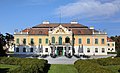 Kasteel Schönborn
 -
 Kaart
Kaart -
 Wapenschild


Text is available under the CC BY-SA 4.0 license; additional terms may apply.
Images, videos and audio are available under their respective licenses.
Cover photo is available under {{::mainImage.info.license.name || 'Unknown'}} license.
Cover photo is available under {{::mainImage.info.license.name || 'Unknown'}} license.
Credit:
(see original file).
