Forrabury and Minster
| Civil parish in Engeland | |||
|---|---|---|---|
| Situering | |||
| Regio | South West England | ||
| Graafschap | Cornwall | ||
| District | (geen) | ||
| Coördinaten | 50°41'2"NB, 4°41'31"WL | ||
| Algemeen | |||
| Oppervlakte | 1,9987 km² | ||
| Inwoners (2011) |
641 (321 inw./km²) | ||
| Overig | |||
| ONS-code | E04011435 | ||
| Foto's | |||

| |||
| Boscastle | |||
| |||
Forrabury and Minster is een civil parish aan de noordkust van Cornwall in Engeland. De belangrijkste nederzetting is Boscastle. Forrabury and Minster heeft iets meer dan 800 inwoners.
-
 Kerk van Boscastle
 -
 Boscastle
 -
 Coastwatch station, Willapark
 -
 Boscastle pier
 -
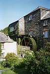 Boscastle Old Mill


Geplaatst op:
29-05-2015
29-05-2015
Dit artikel is een beginnetje over landen & volken. U wordt uitgenodigd om op bewerken te klikken om uw kennis aan dit artikel toe te voegen.
Text is available under the CC BY-SA 4.0 license; additional terms may apply.
Images, videos and audio are available under their respective licenses.
Cover photo is available under {{::mainImage.info.license.name || 'Unknown'}} license.
Cover photo is available under {{::mainImage.info.license.name || 'Unknown'}} license.
Credit:
(see original file).
