Carentan-les-Marais
| Gemeente in Frankrijk | |||
|---|---|---|---|
 | |||
| Situering | |||
| Regio | Normandië | ||
| Departement | Manche (50) | ||
| Arrondissement | Saint-Lô | ||
| Kanton | Carentan-les-Marais en Pont-Hébert | ||
| Coördinaten | 49° 18′ NB, 1° 15′ WL | ||
| Algemeen | |||
| Oppervlakte | 133,29 km² | ||
| Inwoners (1 januari 2021) |
10.220[1] (77 inw./km²) | ||
| Hoogte | 0 - 32 m | ||
| Overig | |||
| Postcode | 50500 | ||
| INSEE-code | 50099 | ||
| Website | Officiële website | ||
| Detailkaart | |||
 | |||
| Foto's | |||

| |||
| Het gemeentehuis te Carentan | |||
| |||
Carentan-les-Marais (voorheen Carentan les Marais) is een gemeente in het Franse departement Manche in de regio Normandië. Deze gemeente maakt deel uit van het arrondissement Saint-Lô. De gemeente telde 10.220 inwoners op 1 januari 2021.[1] Hoofdplaats is de historische stad Carentan, waar het gemeentehuis staat.
In de gemeente ligt spoorwegstation Carentan.
Carentan-les-Marais heeft een jachthaven met 350 plaatsen.[2]
Geschiedenis
[bewerken | brontekst bewerken]Carentan
[bewerken | brontekst bewerken]Carentan is een historische stad die groeide rond een middeleeuwse burcht. De stad kende veel oorlogsgeweld tijdens de Honderdjarige Oorlog en ook in 1944 tijdens de Slag om Carentan.
Commune nouvelle
[bewerken | brontekst bewerken]Op 1 januari 2016 fuseerden de gemeenten Angoville-au-Plain, Carentan, Houesville en Saint-Côme-du-Mont tot een commune nouvelle, waarvan Carentan de hoofdplaats werd. Op januari 2017 sloten de gemeenten Brévands, Saint-Pellerin en Les Veys zich hierbij aan. Op 1 januari 2019 zijn de tussenliggende gemeenten Catz en Saint-Hilaire-Petitville, Montmartin-en-Graignes ten zuiden en Brucheville en Vierville ten noorden opgenomen, waarmee het aantal deelgemeenten op twaalf kwam.
-
 1 januari 2016
 -
 1 januari 2017
 -
 1 januari 2019

.png)
.png)
Geografie
[bewerken | brontekst bewerken]De oppervlakte van Carentan-les-Marais bedroeg op 1 januari 2021 133,29 vierkante kilometer; de bevolkingsdichtheid was toen 76,7 inwoners per km².
De gemeente ligt op de oostkust van het schiereiland Cotentin.
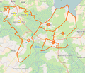
De onderstaande kaart toont de ligging van Carentan-les-Marais met de belangrijkste infrastructuur en aangrenzende gemeenten.

- ↑ a b Populations légales 2021.
- ↑ (fr) Le port de plaisance de Carentan. carentanlesmarais.fr. Geraadpleegd op 21 oktober 2023.
Text is available under the CC BY-SA 4.0 license; additional terms may apply.
Images, videos and audio are available under their respective licenses.
